Maida Hill Tunnel

Last updated

Maida Hill Tunnel
Working Narrowboat - geograph.org.uk - 122777.jpg
Eastern portal of the tunnel, August 1989
Overview
Location Maida Vale, St John's Wood, London
Coordinates 51°31′30.57″N0°10′32.74″W / 51.5251583°N 0.1757611°W / 51.5251583; -0.1757611
OS grid reference
StatusOpen
Waterway Regent's Canal
Start 51°31′28.29″N0°10′37.38″W / 51.5245250°N 0.1770500°W / 51.5245250; -0.1770500
End 51°31′33.13″N0°10′27.25″W / 51.5258694°N 0.1742361°W / 51.5258694; -0.1742361
Operation
Owner Canal and River Trust
Technical
Length272 yards (249 m)
TowpathNo

Maida Hill Tunnel is a canal tunnel on the Regent's Canal in London, England. The two other tunnels on the Regent's Canal are Islington Tunnel and Eyre's Tunnel.

Contents

History

The Regent's Canal was authorised by an Act of Parliament in July 1812. The plans had been drawn up by James Morgan, working as an assistant to the architect John Nash. With some influence from Nash, Morgan secured the post of Engineer, Architect and Land Surveyor for the new company, and oversaw the construction of the canal. However, he had little experience of civil engineering, and so the company advertised for designs for the locks and tunnels. The tunnelling work was awarded to the contractor Daniel Pritchard, [1] who was also responsible for the much longer Grand Union Canal tunnels at Husbands Bosworth and Crick, and went on to become a specialist tunnelling contractor. [2]

The original plans for the canal did not include a tunnel at Maida Hill, but objections to the planned route resulted in one becoming necessary, and subsequent objections to the alignment of the tunnel by a Mr Portman resulted in the short Eyre's Tunnel also needing to be constructed. Work began in 1812, but was hindered when a spring was encountered. Damage caused by the incoming water resulted in casualties among the workmen, and subsequent delays. [3] However, both of the tunnels were completed by 1816, enabling part of the canal to be opened in that year, as far as Camden. Spoil from the excavations was used to level land to the north of the canal, which became the third site of Lord's Cricket Ground. The canal had cut through part of the outfield of the second site. [4]

The tunnel was built without a towpath, and boats were legged through it. In 1825, three men were working a boat through the tunnel when the boards on which they were lying slipped. One man was seriously injured, a second was crushed to death by the barge, and the body of the third was never found. The tunnel is regularly used by trip boats, with the first motor boat, Jasons Trip, starting operation in 1951. In 1953, Evelyn, operated by Lord St Davids, also worked through the tunnel. It was towed by a horse to the east of the tunnel, by a tractor to the west, and human powered through the tunnel. In the 1970s, Westminster City Council decided to build a cafe at the west end of the tunnel. Despite strong local opposition, a concrete and steel raft was constructed over the western portal, and the Cafe Laville was built on it. [4]

Route

The tunnel lies on a 27-mile (43 km) level section of canal. To the east are Camden Locks, the first three of twelve locks through which the canal descends 96 feet (29 m) to Limehouse Basin, from which Limehouse Lock provides access to the Thames. [5] After passing under the A5205 road bridge, there is a right-angled bend after the locks, with the stub of Cumberland Basin to the left. The route then follows the northern edge of Regent's Park, which houses London Zoo. There is a long wooded cutting, before the canal skirts a housing estate built on the site of the former Marylebone goods yard. It then passes through Eyre's Tunnel, which is often known as Lisson Grove Bridge, and into the eastern portal of Maida Hill Tunnel. [6] The tunnel runs underneath Aberdeen Place on which stands the renowned Crocker's Folly Hotel, so called because it was reputed to have been built in anticipation of the arrival of the railway which went to Marylebone instead. After that it passes beneath Edgware Road to emerge at the western portal [7] with its restaurant above. The section between the tunnel mouth and Little Venice is tree-lined, with fine Regency houses on both sides. There is a junction with the Paddington Arm, leading to Paddington Basin, and the main line of the canal continues westwards to Old Oak Common, where Eurostar trains are stabled, and Wormwood Scrubs park and prison. [6]

The canal through the tunnel is navigable by wide-beam boats, with a beam of 14.5 feet (4.4 m), a draught of 4 feet (1.2 m), a length of 816.93 feet (249.00 m) [8] and headroom of 8.5 feet (2.6 m). The tunnel is 0.4 miles (0.64 km) from Paddington Junction, and 1.9 miles (3.1 km) from Hampstead Road Locks, a pair of locks which begin the fall to the Thames, and home to the Camden Canal Centre. [9] There are a number of trip boats which operate on the section between Little Venice and Camden Locks, passing through the tunnel and calling at the zoo, and the tunnel is only wide enough for one way traffic. Boats are therefore required to give way if another boat is approaching in the opposite direction. [10]

In 2016, the Canal & River Trust provisionally opened access to non-powerfed craft such as kayaks, packrafts and canoes. [11]

Bibliography

Related Research Articles

<span class="mw-page-title-main">Grand Union Canal</span> Canal in England

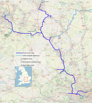
The Grand Union Canal in England is part of the British canal system. It is the principal navigable waterway between London and the Midlands. Starting in London, one arm runs to Leicester and another ends in Birmingham, with the latter stretching for 137 miles (220 km) with 166 locks from London. The Birmingham line has a number of short branches to places including Slough, Aylesbury, Wendover, and Northampton. The Leicester line has two short arms of its own, to Market Harborough and Welford.

<span class="mw-page-title-main">Paddington</span> Area of central London, England

Paddington is an area in the City of Westminster, in central London, England. A medieval parish then a metropolitan borough, it was integrated with Westminster and Greater London in 1965. Paddington station, designed by the engineer Isambard Kingdom Brunel opened in 1847. It is also the site of St Mary's Hospital and the former Paddington Green Police Station.

<span class="mw-page-title-main">Stratford-upon-Avon Canal</span> United Kingdom legislation

The Stratford-upon-Avon Canal is a canal in the south Midlands of England. The canal, which was built between 1793 and 1816, runs for 25.5 miles (41.0 km) in total, and consists of two sections. The dividing line is at Kingswood Junction, which gives access to the Grand Union Canal. Following acquisition by a railway company in 1856, it gradually declined, the southern section being un-navigable by 1945, and the northern section little better.

<span class="mw-page-title-main">Limehouse Basin</span> Canal basin in Tower Hamlets, London

Limehouse Basin is a body of water 2 miles east of London Bridge that is also a navigable link between the River Thames and two of London's canals. First dug in 1820 as the eastern terminus of the new Regent's Canal, its wet area was less than 5 acres originally, but it was gradually enlarged in the Victorian era, reaching a maximum of double that size, when it was given its characteristic oblique entrance lock, big enough to admit 2,000-ton ships.

<span class="mw-page-title-main">Regent's Canal</span> Canal in England

Regent's Canal is a canal across an area just north of central London, England. It provides a link from the Paddington Arm of the Grand Union Canal, 550 yards (500 m) north-west of Paddington Basin in the west, to the Limehouse Basin and the River Thames in east London. The canal is 8.6 miles (13.8 km) long.

<span class="mw-page-title-main">Dudley Tunnel</span> Canal tunnel on the Dudley Canal

Dudley Tunnel is a canal tunnel on the Dudley Canal Line No 1, England. At about 3,172 yards (2,900.5 m) long, it is now the second longest canal tunnel on the UK canal network today.. However, since the Dudley Tunnel is not continuous this status is sometimes questioned:.

<span class="mw-page-title-main">Camden Lock</span> Grade II listed lock in London Borough of Camden, UK

Camden Lock is a small part of Camden Town, London Borough of Camden, England, which was formerly a wharf with stables on the Regent's Canal. It is immediately to the north of Hampstead Road Locks, a twin manually operated lock. The twin locks together are "Hampstead Road Lock 1"; each bears a sign so marked. Hawley Lock and Kentish Town Lock are a short distance away to the east; to the west is a long level pound — it is 27 miles (43 km) to the next lock.

<span class="mw-page-title-main">Dudley Canal</span> Canal in the West Midlands, England

The Dudley Canal is a canal passing through Dudley in the West Midlands of England. The canal is part of the English and Welsh network of connected navigable inland waterways and forms part of the popular Stourport Ring narrowboat cruising route.

<span class="mw-page-title-main">Norwood Tunnel</span> Canal tunnel in Derbyshire, England

Norwood Tunnel was a 2,884-yard-long, 9-foot-3-inch-wide (2.82 m) and 12-foot-high (3.7 m) brick lined canal tunnel on the line of the Chesterfield Canal with its Western Portal in Norwood, Derbyshire and its Eastern Portal in Kiveton, South Yorkshire, England.

<span class="mw-page-title-main">South Pennine Ring</span>

The South Pennine Ring is an English canal ring which crosses the Pennines between Manchester and Huddersfield. It covers parts of five canals, and includes passage through the longest canal tunnel in Britain. It has only been possible to cruise it since 2002, when restoration of the Huddersfield Narrow Canal provided the return route across the Pennines.

<span class="mw-page-title-main">Four Counties Ring</span>

The Four Counties Ring is a canal ring which links the four English counties of Cheshire, Staffordshire, Shropshire and West Midlands.

<span class="mw-page-title-main">North Pennine Ring</span>

The North Pennine Ring is a canal ring which crosses the Pennines between Manchester, Leeds and Castleford. It follows parts of five canals, and shares much of its route with the Outer Pennine Ring, which uses a different route for the southern crossing of the Pennines.

<span class="mw-page-title-main">Outer Pennine Ring</span>

The Outer Pennine Ring is an English canal ring which crosses the Pennines between Manchester, Leeds and Castleford. Its route follows parts of eight canals, and includes the longest canal tunnel in England. The ring was completed in 2001, with the opening of the Huddersfield Narrow Canal. Much of the route is shared with the North Pennine Ring, which crosses the Pennines by a different route on the southern leg.

<span class="mw-page-title-main">Dukinfield Junction</span>

Dukinfield Junction is the name of the canal junction where the Peak Forest Canal, the Ashton Canal and the Huddersfield Narrow Canal meet near Ashton-under-Lyne, Greater Manchester, England. The area has been designated by Tameside Metropolitan Borough Council as a conservation area.

<span class="mw-page-title-main">Islington Tunnel</span> Tunnel on the Regents Canal, London

The Islington Tunnel takes the Regent's Canal 960 yards (878 m) under Islington, as the longest such tunnel in London. The way for short boats and barges only opened in 1818; the pavements above are waymarked so the otherwise discontinued towpaths are connected. The canal's Eyre's and Maida Hill Tunnels, to the west, are much shorter.

<span class="mw-page-title-main">St Pancras Lock</span> Lock in London Borough of Camden, London, England, UK

St Pancras Lock is a lock on the Regent's Canal, in the London Borough of Camden, England. The St Pancras Basin is nearby.

<span class="mw-page-title-main">City Road Lock</span> Lock on the Regents Canal, London

City Road Lock is a lock on the Regent's Canal, in the London Borough of Islington, England. It is located a short distance to the east of Islington Tunnel, and immediately to the west of City Road Basin.

<span class="mw-page-title-main">Transport on the Regent's Canal</span>

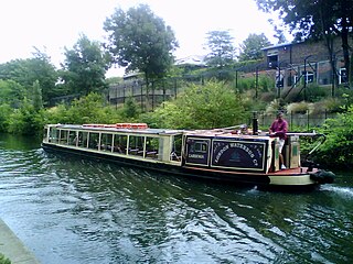
Several private boat companies operate services which provide Transport on the Regent's Canal. The services run along the Regent's Canal in London, England, UK, and are open to the public. They provide both leisure cruises and regular scheduled "water bus" services along the canal between Little Venice, London Zoo and Camden Lock.

<span class="mw-page-title-main">Paddington Arm</span>

The Paddington Canal or Paddington Arm of the Grand Union Canal is a 13+12-mile (22 km) canal to Paddington in central London, England. It runs from the west of the capital at Bull's Bridge in Hayes. Little Venice — its only junction — is with the Regent's Canal, London that runs to Limehouse Basin to the east. The arm and the two canals it links are fed by water by the Brent Reservoir. The Paddington Arm is part of a long pound that stretches for nearly thirty miles.

References

  1. Skempton 2002, p. 452.
  2. Skempton 2002, pp. 537–538.
  3. "Canal Tunnels of London". Canal Museum. Retrieved 24 December 2015.
  4. 1 2 "London's Three Canal Tunnels". London Canals. Archived from the original on 3 March 2015. Retrieved 24 December 2015.
  5. Nicholson 2006, pp. 20–25.
  6. 1 2 Nicholson 2006, pp. 24–25.
  7. 1:2500 map, Streetmap.co.uk
  8. "Maida Hill Tunnel - Regent's Canal". Canal & River Trust. Retrieved 4 January 2020.
  9. Cumberlidge 2009, p. 136.
  10. Nicholson 2006, p. 25.
  11. "Unpowered craft in Maida Hill Tunnel". Canal & River Trust. Retrieved 4 January 2020.