Related Research Articles
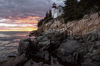
Acadia National Park is an American national park located along the mid-section of the Maine coast, southwest of Bar Harbor. The park preserves about half of Mount Desert Island, part of the Isle au Haut, the tip of the Schoodic Peninsula, and portions of 16 smaller outlying islands. It protects the natural beauty of the rocky headlands, including the highest mountains along the Atlantic coast. Acadia boasts a glaciated coastal and island landscape, an abundance of habitats, a high level of biodiversity, clean air and water, and a rich cultural heritage.

Falmouth is a town in Cumberland County, Maine, United States. The population was 12,444 at the 2020 census. It is part of the Portland–South Portland–Biddeford, Maine metropolitan statistical area.
Sullivan is a town in Hancock County, Maine, United States. The population was 1,219 at the 2020 census. The town was named for Daniel Sullivan, an early settler. Colloquially referred to as "Sully" or "the Sullivans"—like many Maine municipalities composed of villages with geographic designations of the town proper—the municipality was incorporated in 1789. Located in the Upper Schoodic Peninsula sub-region of Maine's Downeast Acadia region, the municipality has been known as "Waukeag", "New Bristol", and later Sullivan; and once included the nearby communities of Hancock, Sorrento, and what would later be Township 7, South & Middle Districts. Once home to abundant granite quarries, the town of Sullivan is now a residential community for nearby Ellsworth and Mount Desert Island. Located along U.S. Route 1, the Taunton River, and Hog Bay, Sullivan is home to a reversing tidal falls and many scenic turnouts that dot the Schoodic National Scenic Byway along the Upper Schoodic Peninsula.

Mount Desert Island in Hancock County, Maine, is the largest island off the coast of Maine. With an area of 108 square miles (280 km2) it is the 52nd-largest island in the United States, the sixth-largest island in the contiguous United States, and the second-largest island on the Eastern Seaboard, behind Long Island and ahead of Martha's Vineyard. According to the 2010 census, the island has a year-round population of 10,615. In 2017, an estimated 3.5 million tourists visited Acadia National Park on MDI. The island is home to numerous well-known summer colonies such as Northeast Harbor and Bar Harbor.
"Down East", also "Downeast", is a term for parts of eastern coastal New England and Canada, particularly the U.S. state of Maine and Canada's Maritime Provinces, an area that closely corresponds to the historical French territory of Acadia. The phrase apparently derives from sailing terminology: sailors from western ports sailed downwind toward the east to reach the area.
Land trusts are nonprofit organizations which own and manage land, and sometimes waters. There are three common types of land trust, distinguished from one another by the ways in which they are legally structured and by the purposes for which they are organized and operated:

Penobscot Bay is an inlet of the Gulf of Maine and Atlantic Ocean in south central Maine. The bay originates from the mouth of Maine's Penobscot River, downriver from Belfast. Penobscot Bay has many working waterfronts including Rockland, Rockport, and Stonington, and Belfast upriver. Penobscot Bay is between Muscongus Bay and Blue Hill Bay, just west of Acadia National Park.
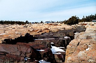
The Schoodic Peninsula is a peninsula in Down East Maine. It is located four miles (6 km) east of Bar Harbor, Maine, as the crow flies. The Schoodic Peninsula contains 2,266 acres (9 km2), or approximately 5% of Acadia National Park. It includes the towns of Gouldsboro and Winter Harbor. The peninsula has a rocky granite shoreline containing many volcanic dikes. The peninsula is home to the former United States Navy base, NSGA Winter Harbor, which has been converted into a National Park Service training center. A 3,300-acre (13 km2) resort development was proposed for land abutting Schoodic Peninsula's national park holdings to the north. An anonymous donor eventually bought the entire 3,200-acre tract and built the Schoodic Woods Campground and miles of gravel bike paths before donating all of it to Acadia National Park. Opening in 2015, Schoodic Woods is the newest campground in Acadia National Park, and the first built in the park since the original campgrounds were built by the Civilian Conservation Corps during the Great Depression beginning in 1936. In the summer, the Schoodic peninsula is currently served by two separate ferry services from Bar Harbor to Winter Harbor that run daily.
Sears Island, known as Wassumkeag or shining beach by the indigenous Wabanaki tribes of northern New England, is located off the coast of Searsport in Waldo County, Maine, at the top of Penobscot Bay. The island is the largest undeveloped, uninhabited, causeway-accessible island on the eastern coast of the United States. It is 940 acres (3.8 km2) in area. It is part of the Town of Searsport.

Naval Security Group Activity, Winter Harbor was a radio station of the United States Navy that operated from 1935 to 2002.
California Rangeland Trust is a conservation nonprofit organization founded in 1998. The Rangeland Trust claims to be the largest land trust in California, having conserved over 371,000 acres (1,500 km2) of rangeland on 90 ranches across 26 counties.
Robert O. Binnewies is an American conservationist. Graduate, Colorado State University, 1959, bachelor of science degree, forest recreation. Joined National Park Service, 1961, as a park ranger, Yellowstone National Park, Wyoming. Subsequent NPS assignments included Washington, D.C., 1964–1966, chief ranger, Acadia National Park, Maine, 1967–1971, and superintendent, Yosemite National Park, California, 1979–1986.

Ragged Island is a privately owned island in Harpswell, Maine, United States, in Cumberland County, which is geographically within Casco Bay in the Gulf of Maine. It is located at 43°43′39″N69°56′13″W.
Pond Island is a small 32-acre (13 ha) island in Penobscot Bay, on the central coast of Maine, United States. The island is a conservation property of the Maine Coast Heritage Trust, and is open to the public, with two small campsites. The island was listed on the National Register of Historic Places in 1979 for the significance of its prehistoric archaeological sites. It is named for the saltwater pond located at its center.
Birch Point, also known as Clark's Point, is a peninsula in Machiasport, Maine. It separates Sanborn Cove to the north from Larrabee Cove to the south on the west side of Machias Bay, a short way south of the mouth of the Machias River. The point is of prehistoric and historic importance to the local Passamaquoddy people, as it is the site of large panels of rock art which have been listed on the National Register of Historic Places.

The Beech Hill Preserve is a conservation property in Rockport, Maine. Its 295 acres (119 ha) include the summit of Beech Hill, one of the few bare-topped hills in the area. Its features include forested lower slopes, a commercial blueberry operation, and a 1913 Norwegian sod-roofed hut at the summit of the hill. It has been protected by conservation easements since 1987, and is now owned and managed by the Coastal Mountains Land Trust. The hut, its access road, and the gate on Beech Hill Road were listed on the National Register of Historic Places as the Beechnut Hut Historic District in 2003.
Marshall Island is an island and unorganized territory in Hancock County, Maine, United States. It lies where Penobscot Bay and Blue Hill Bay meet, between Swan's Island and Isle au Haut. Uninhabited, it is one of the largest undeveloped islands surrounding the contiguous United States.

The Chebeague & Cumberland Land Trust is a volunteer-run conservation group based in Cumberland, Maine, United States. Established in 1987 and funded by its members, it owns many preserves and trail networks, and has assisted in the creation of town-owned parks and preserves. The trust, one of eighty land trusts in Maine, covers the towns of Cumberland and Chebeague Island.
The Maine Land Trust Network promotes discussion among the eighty land trusts in Maine, United States. It was established in 1995.
References
- ↑ "Land Trusts by County". Maine Land Trust Network. Retrieved 2023-04-09.
- ↑ "Homepage 2022e". Maine Land Trust Network. Retrieved 2023-04-09.
- 1 2 "A Necklace of Coastal Gems | Maine Coast Heritage Trust". New England Today. April 6, 2020. Archived from the original on January 9, 2022. Retrieved January 9, 2022.
- 1 2 "Maine Coast Heritage Trust: Preserving the Coast". 2020-10-19. Retrieved 2022-02-12.
- ↑ "OBITUARY -- Margaret Rockefeller". The San Francisco Chronicle. 1996-03-28. Retrieved 2022-02-12.
- ↑ "Going Beyond Preservation". 2021-09-22. Retrieved 2022-02-12.
- ↑ Sharon, Susan (December 20, 2021). "Maine Coast Heritage Trust conserves 1,700 acres on Schoodic Peninsula". Maine Public.
- ↑ Ohm, McGuire; Rachael, Peter (December 20, 2021). "Community support leads to preservation of undeveloped Casco Bay islands". Portland Press Herald.
- ↑ "Maine nonprofit buys Penobscot Bay island for $1.6 million". Associated Press. December 29, 2021.
- ↑ Forecaster, Brielle HardyThe (December 31, 2020). "Maine Coast Heritage Trust leads major conservation effort in Yarmouth". Press Herald. Archived from the original on January 9, 2022. Retrieved January 9, 2022.
- ↑ Cassidy, Katherine (October 24, 2006). "MCHT Purchases Restores Machias Bay Shoreland To Tribe". Bangor Daily News.
- ↑ Collier, Jay (2019-04-19). "Our Story". Maine Coast Heritage Trust. Retrieved 2022-04-30.
- ↑ "Maine Coast Heritage Trust president to retire". The Ellsworth American. 2021-12-03. Retrieved 2022-02-11.
- ↑ Trotter, Bill (April 28, 2019). "25 years after a house was built on it, a Maine island has been given back to the birds". Bangor Daily News. Archived from the original on January 16, 2022. Retrieved January 9, 2022.
- ↑ Riddle, Lyn (May 28, 1989). "NORTHEAST NOTEBOOK: York, Me.; Open-Space Easements". The New York Times. ISSN 0362-4331. Archived from the original on January 9, 2022. Retrieved January 9, 2022.