
An artificial island or man-made island is an island that has been constructed by people rather than formed by natural means. Artificial islands may vary in size from small islets reclaimed solely to support a single pillar of a building or structure, to those that support entire communities and cities. Early artificial islands included floating structures in still waters, or wooden or megalithic structures erected in shallow waters.

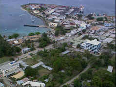
Auki is the provincial capital of Malaita Province, Solomon Islands. It is situated on the northern end of Langa Langa Lagoon on the north-west coast of Malaita Island. It is one of the largest provincial towns in Solomon Islands. It was established as the administrative center for Malaita Province in 1909.

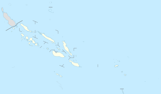
Malaita Province is one of the largest of the nine provinces of Solomon Islands. It is named after its largest island, Malaita. Other islands include South Malaita Island, Sikaiana Island, and Ontong Java Atoll. Britain defined its area of interest in the Solomons, including Malaita, and central government control of Malaita began in 1893, when Captain Gibson R.N., of HMS Curacoa, declared the southern Solomon Islands as a British Protectorate with the proclamation of the British Solomon Islands Protectorate.

Boigu Island is the most northerly inhabited island of Queensland and of Australia. It is part of the top-western group of the Torres Strait Islands, which lie in the Torres Strait separating Cape York Peninsula from the island of New Guinea. The mainland of Papua New Guinea is only 6 kilometres (3.7 mi) away from Boigu. Boigu has an area of 89.6 square kilometres (34.6 sq mi). Boigu is also the name of the town and Boigu Island is the name of the locality on the island within the Torres Strait Island Region.
Brief Information on First settlers:

Malaita is the largest island of the Malaita Province in Solomon Islands. South Malaita Island, also known as Small Malaita and Maramasike for Areare speakers and Malamweimwei known to more than 80% of the islanders, is the island at the southern tip of the larger island of Malaita. A tropical and mountainous island, Malaita's pristine river systems and tropical forests have not been exploited. Malaita is the second most populous island of the Solomon Islands, with a population of 140,000, or more than a third of the entire national population. The largest city and provincial capital is Auki, on the northwest coast and is on the northern shore of the Langa Langa Lagoon. The people of the Langa Langa Lagoon and the Lau Lagoon on the northeast coast of Malaita call themselves wane i asi ‘salt-water people’ as distinct from wane i tolo ‘bush people’ who live in the interior of the island.
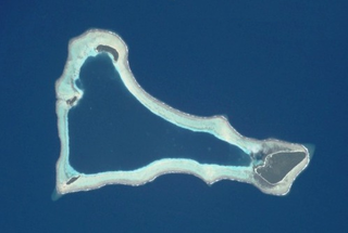
Sikaiana is a small atoll 212 kilometres NE of Malaita in Solomon Islands in the south Pacific Ocean. It is almost 14 kilometres in length and its lagoon, known as Te Moana, is totally enclosed by the coral reef. Its total land surface is only 2 square kilometres. There is no safe anchorage close to this atoll, which makes it often inaccessible to outsiders.
The South Seas Evangelical Church (SSEC) is an evangelical, Pentecostal church in the Solomon Islands. In total, 17% of the population of the Solomon Islands adheres to the church, making it the third most common religious affiliation in the country behind the Anglican Church of Melanesia and the Roman Catholic Church. The SSEC is particularly popular on Malaita, the most populous island, where 47% of its members live; there are also smaller populations in Honiara and elsewhere on Guadalcanal, on Makira, and in other provinces.
Peter Ambuofa was an early convert to Christianity among Solomon Islanders who established a Christian community on Malaita, and a key figure in the history of the South Seas Evangelical Mission.
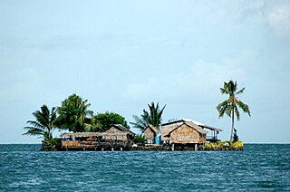
Lau Lagoon is a part of Solomon Islands. It is located on the northeast coast of Malaita Island. The lagoon is more than 35 kilometers long and contains about 60 artificial islands built on the reef.

The Cruise of the Snark (1911) is a non-fictional, illustrated book by Jack London chronicling his sailing adventure in 1907 across the south Pacific in his ketch the Snark. Accompanying London on this voyage was his wife Charmian London and a small crew. London taught himself celestial navigation and the basics of sailing and of boats during the course of this adventure and describes these details to the reader. He visits exotic locations including the Solomon Islands and Hawaii, and his first-person accounts and photographs provide insight into these remote places at the beginning of the 20th century.
White River is a suburb on the fringe of Honiara, Solomon Islands and is located 3 kilometres (1.9 mi) west of the main center on the Tandai Highway. White River is in the Honiara City Council ward of Nggosi. A water spring supplies water to the community.
Funaafou or Funa'afou is an artificial island built on the reef in the Lau Lagoon off the northeast coast of Malaita Island. Administratively, it is in the Malaita Province of the Solomon Islands. Funa'afou island, which is near the edge of the Makwanu Passage, has about 200 inhabitants. It is the first artificial Island built in the Lau lagoon. According to history, the people of Baleo tribe are the first descendants of Funafou Islands

Laulasi island is an artificial island in the Langa Langa Lagoon, South of Auki on the island of Malaita in the Solomon Islands. It is believed that hostilities among the inlanders of Malaita forced some people into the lagoon where over time they built their islands on sandbars after diving for coral. The religion of the island was based on prayers and offerings to the ghosts of dead ancestors, mediated by priests who kept their skulls and relics in tabu houses. Some ancestors were incarnated as sharks which protected their descendants. Langalanga is also the main source of the shell money now made in Solomon Islands.

Langa Langa Lagoon or Akwalaafu is a natural lagoon on the West coast of Malaita near the provincial capital Auki within the Solomon Islands. The lagoon is 21 km in length and just under 1 km wide. The "lagoon people" or "salt water people" live on small artificial islands built up on sand bars over time where they were forced to flee from the headhunters of mainland Malaita.
Tavanipupu is an island in the Solomon Islands. It is located in Marau Sound, at the eastern end of Guadalcanal, between Towara'o Island and Marapa Island, and is part of Guadalcanal Province.
Adagege is an artificial island built on the reef in the Lau Lagoon on Malaita in the Solomon Islands; it is located in Malaita Province. The road from Auki ends at Fouia wharf opposite the islands of Sulufou and Adaege in the Lau Lagoon.
Sulufou is an artificial island built on the reef in the Lau Lagoon on Malaita in the Solomon Islands; it is located in Malaita Province. The road from Auki ends at Fouia wharf opposite the islands of Sulufou and Adaege in the Lau Lagoon.
Honiara is the capital city of Solomon Islands, situated on the northwestern coast of Guadalcanal. As of 2017, it had a population of 84,520 people.
Dolphin are hunted in Malaita in the Solomon Islands in the South Pacific, mainly for their meat and teeth, and also sometimes for live capture for dolphinariums. Dolphin drive hunting is practised by coastal communities around the world; the animals are herded together with boats and then into a bay or onto a beach. A large-scale example is the Taiji dolphin drive hunt, made famous by the Oscar-winning documentary film The Cove. The hunt on South Malaita Island is smaller in scale. After capture, the meat is shared equally between households. Dolphin teeth are also used in jewelry and as currency on the island.
