
The M60 motorway, Manchester Ring Motorway or Manchester Outer Ring Road is an orbital motorway in North West England. Built over a 40-year period, it passes through most of Greater Manchester's metropolitan boroughs except for Wigan and Bolton. Most of Manchester is encompassed within the motorway, except for the southernmost part of the city which is served by the M56.

The M62 is a 107-mile-long (172 km) west–east trans-Pennine motorway in Northern England, connecting Liverpool and Hull via Manchester, Bradford, Leeds and Wakefield; 7 miles (11 km) of the route is shared with the M60 orbital motorway around Manchester. The road is part of the unsigned Euroroutes E20 and E22.

The M67 is a 5-mile (8.0 km) urban motorway in Greater Manchester, England, which heads east from the M60 motorway passing through Denton and Hyde before ending near Mottram. The road was originally conceived as the first section of a trans-Pennine motorway between Manchester and Sheffield that would connect the A57(M) motorway with the M1 motorway; however, the motorway became the only part to be built.

The M56 motorway serves the Cheshire and Greater Manchester areas of England. It runs east to west from junction 4 of the M60 at Gatley, south of Manchester, to Dunkirk, approximately four miles north of Chester. With a length of 33.3 miles (53.6 km), it connects North Wales and the Wirral peninsula with much of the rest of North West England, serves business and commuter traffic heading towards Manchester, particularly that from the wider Cheshire area, and provides the main road access to Manchester Airport from the national motorway network.

The M61 is a motorway in North West England between Manchester and Preston, linking the M60 Manchester orbital motorway with the M6 motorway.
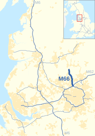
The M66, also known as the Bury Easterly Bypass, is a motorway in Lancashire and Greater Manchester, England. It is 8 miles (13 km) long and provides part of the route between the M62 and M60 motorways and the M65, with the rest being provided by the A56.

The M602 motorway is a 4-mile (6.4 km) motorway, leading traffic into Salford, Greater Manchester, England, towards Manchester and by-passing the town of Eccles.

Brough and Shatton is a civil parish in Hope Valley in the High Peak district of Derbyshire, England. It is named for the two hamlets of Brough-on-Noe and Shatton. Brough is about 2 km, or just over 1 mile, west (upstream) of Shatton; both are on the River Noe, a tributary of the upper River Derwent. They lie within the Peak District National Park, about 15 miles west of Sheffield and 30 miles east of Manchester. According to the 2011 census, Brough and Shatton had a combined population of 136. There is a friendly rivalry between the two hamlets, which contest numerous sports competitions throughout the year.

Bramhall railway station serves the district of Bramhall in the Metropolitan Borough of Stockport, Greater Manchester, England. The station is 9¾ miles (16 km) south of Manchester Piccadilly on the Stafford to Manchester Line and was opened in 1845 by the London and North Western Railway.

The geography of Greater Manchester is dominated by one of the United Kingdom's largest metropolitan areas, and in this capacity the landlocked metropolitan county constitutes one of the most urbanised and densely populated areas of the country. There is a mix of high density urban areas, suburbs, semi-rural and rural locations in Greater Manchester, but overwhelmingly the land use in the county is urban.
Castlesteads is an Iron Age promontory fort, situated on the east bank of the River Irwell on a natural promontory in Bury, Greater Manchester. It is listed as a Scheduled Ancient Monument. Excavated pottery indicates the site was occupied between 200BC and 250AD.

The River Tib is a minor tributary of the River Medlock in Manchester, England. It has been culverted along its entire length since about 1783 and now runs beneath Manchester city centre. Tib Street and Tib Lane are named after the watercourse.

Grove House, on Oxford Road, Chorlton-on-Medlock, Manchester, England, is an early Victorian building, originally three houses, of 1838–40. It is a Grade II* listed building as of 18 December 1963.

Jackson's Warehouse is a 19th-century warehouse in the Piccadilly Basin area of Manchester, England.

Brownsfield Mill, located on Binns Place, Great Ancoats Street in Manchester, England, is an early 19th century room and cotton-spinning power mill constructed in 1825. Hartwell describes it as "unusually complete and well preserved". The chimney is now Manchester's oldest surviving mill chimney. The building housed the A.V. Roe and Company aviation factory in the early 20th century. In 1988, it was designated a Grade II* listed building.

The 1992 Manchester bombing was an attack by the Provisional Irish Republican Army (IRA) on Thursday, 3 December 1992. Two 2 lb (0.9 kg) bombs exploded, wounding 64 people and damaging several buildings in the city of Manchester.
107 Piccadilly is a Grade-II listed building on Piccadilly and Lena Street in Manchester, England. Situated near Piccadilly Gardens, it was originally built as a packing warehouse and showroom with offices for cotton manufacturer Sparrow Hardwick & Company.

Lincoln House was an office building on Deansgate in Manchester, England. It was designed in the 1980s by Holford Associates. It was completely clad in glass and was designed as a deliberate response to the 1960s and 1970s Brutalist architecture common in many British cities. It was built in 1986 for the Lincoln House Chambers, a legal practice based in Manchester.

50 Newton Street is a Grade II listed former warehouse in Manchester, England. It is located on Newton Street in the Northern Quarter area
