
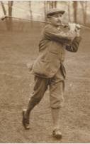
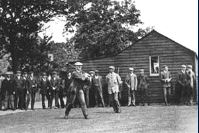
John Henry "J.H." Taylor was an English professional golfer and one of the pioneers of the modern game of golf. Taylor is considered to be one of the best golfers of all time. He was a significant golf course architect. Taylor helped to found the British PGA, the world's first, and became respected for his administrative work. He also wrote two notable golf books.

Trafford is a metropolitan borough of Greater Manchester, England, with an estimated population of 235,546 in 2021. It covers 106 square kilometres (41 sq mi) and includes the area of Old Trafford and the towns of Altrincham, Stretford, Urmston, Partington and Sale. The borough was formed in 1974 as a merger of six former districts and part of a seventh. The River Mersey flows through the borough, separating North Trafford from South Trafford, and the historic counties of Lancashire and Cheshire. Trafford is the seventh-most populous district in Greater Manchester.

Sale is a town in Trafford, Greater Manchester, England, in the historic county of Cheshire on the south bank of the River Mersey, 2 miles (3.2 km) south of Stretford, 3 miles (4.8 km) northeast of Altrincham, and 5 miles (8.0 km) southwest of Manchester. In 2021, it had a population of 54,515.

Rochdale is a town in Greater Manchester, England, and the administrative centre of the Metropolitan Borough of Rochdale. In the 2021 census the town had a population of 111,261, compared to 223,773 for the wider borough. Rochdale is in the foothills of the South Pennines and lies in the dale (valley) of the River Roch, 5 miles (8 km) northwest of Oldham, and 10 miles (16 km) northeast of Manchester.

Timperley is a suburban area in the borough of Trafford, Greater Manchester, England. Within the boundaries of the historic county of Cheshire, it is approximately six miles southwest of central Manchester. The population at the 2011 census was 11,061.

Middleton is a largely residential suburb of Leeds in West Yorkshire, England and historically a village in the West Riding of Yorkshire. It is situated on a hill 4 miles (6 km) south of Leeds city centre and 165 miles (266 km) north north-west of London.
Stretford is a market town in Trafford, Greater Manchester, England. It is situated on flat ground between the River Mersey and the Manchester Ship Canal, 4 miles (6.4 km) south of Manchester, 3 miles (4.8 km) south of Salford and 4 miles (6.4 km) north-east of Altrincham. Stretford borders Chorlton-cum-Hardy to the east, Moss Side and Whalley Range to the south-east, Hulme to the north-east, Urmston to the west, Salford to the north, and Sale to the south. The Bridgewater Canal bisects the town.

Middleton is a town in the Metropolitan Borough of Rochdale, Greater Manchester, England, on the River Irk 5 miles (8.0 km) southwest of Rochdale and 5 miles (8.0 km) northeast of Manchester. Middleton had a population of 42,972 at the 2011 Census. It lies on the northern edge of Manchester, with Blackley to the south and Moston to the south east have it large.

Heywood is a town in the Metropolitan Borough of Rochdale, Greater Manchester, England, in the historic county of Lancashire. It had a population of 28,205 at the 2011 Census. The town lies on the south bank of the River Roch, 2 miles (3.2 km) east of Bury, 4 miles (6.4 km) southwest of Rochdale, and 8 miles (12.9 km) north of Manchester. Middleton lies to the south, whilst to the north is the Cheesden Valley, open moorland, and the Pennines. Heywood's nickname is Monkey Town.

Urmston is a town in Trafford, Greater Manchester, England, which had a population of 41,825 at the 2011 Census. Historically in Lancashire, it is 5 miles (8 km) southwest of Manchester city centre. The southern boundary is the River Mersey, with Stretford lying to the east and Flixton to the west. Davyhulme lies to the north of the town centre. Urmston covers an area of 4,799 acres (19.42 km2).
Hale Barns is a village near Altrincham in Greater Manchester, England, 7 miles (11 km) south-west of Manchester city centre, 2 miles west of Manchester Airport and close to the River Bollin. At the 2011 census, the village had a population of 9,736.

Heaton Park is a public park in Manchester, England, covering an area of over 600 acres (242.8 ha). The park includes the grounds of a Grade I listed, neoclassical 18th century country house, Heaton Hall. The hall, remodelled by James Wyatt in 1772, is now only open to the public on an occasional basis as a museum and events venue. It is the biggest park in Greater Manchester, and also the largest municipal park in Europe.

Flixton is a suburb and electoral ward in the Metropolitan Borough of Trafford, Greater Manchester, England. The population of the ward at the 2011 census was 10,786. It lies six miles (9.7 km) southwest of Manchester city centre, in the historic county of Lancashire.

Trafford Park is an area of the Metropolitan Borough of Trafford, Greater Manchester, England, opposite Salford Quays on the southern side of the Manchester Ship Canal, 3.4 miles (5.5 km) southwest of Manchester city centre and 1.3 miles (2.1 km) north of Stretford. Until the late 19th century, it was the ancestral home of the Trafford family, who sold it to financier Ernest Terah Hooley in 1896. Occupying an area of 4.7 square miles (12 km2), it was the first planned industrial estate in the world, and remains the largest in Europe well over a century later.
The Grover Cleveland Golf Course is a historic golf course located in Buffalo, New York that hosted the 1912 U.S. Open that was founded as The Country Club of Buffalo. It is one of two courses owned by Erie County.

Hopwood Hall College is a further education college in the Metropolitan Borough of Rochdale, Greater Manchester, England. It has two campuses, one in Rochdale (53.6168°N 2.1626°W) and one in Middleton (53.5690°N 2.1889°W). The college offers a wide range of vocational and technical study programmes aimed at young people aged 16–19, with some university level courses, Apprenticeship programmes and adult education.

New Moston is a suburb of Manchester, England.
Thomas George Renouf was an English professional golfer from Jersey who played in the late 19th and early 20th century. He had multiple top-10 finishes in the Open Championship. His best result was fifth in the 1909 Open Championship. Renouf caddied in his youth at Royal Jersey Golf Club and became a skilled club maker as well as a manufacturer of golf balls.
Phillip John Gaudin was a professional golfer from Jersey who played in the late 19th and early 20th century. He had three top-10 finishes in the Open Championship. His best result was a tie for eighth place in the 1914 Open Championship. He tied for ninth place in both the 1901 and 1908 Open Championships.
