Hydra, or Ydra or Idra, and in antiquity Hydrea, is one of the Saronic Islands of Greece, located in the Aegean Sea between the Myrtoan Sea and the Argolic Gulf. It is separated from the Peloponnese by a narrow strip of water. In ancient times, the island was known as Hydrea, a reference to the natural springs on the island.
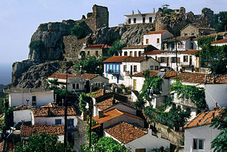
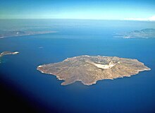
Samothrace is a Greek island in the northern Aegean Sea. It is a municipality within the Evros regional unit of Thrace. The island is 17 km (11 mi) long, 178 km2 (69 sq mi) in size and has a population of 2,596. Its main industries are fishing and tourism. Resources on the island include granite and basalt. Samothrace is one of the most rugged Greek islands, with Mt. Saos and its highest peak Fengari rising to 1,611 m (5,285 ft). The Winged Victory of Samothrace statue, which is now displayed at the Louvre in Paris, originates from the island.

Salamis or Salamina is the largest Greek island in the Saronic Gulf, about two kilometres from the coast of Piraeus and about 16 km west of central Athens. The chief city, Salamina, lies in the west-facing core of the crescent on Salamis Bay, which opens into the Saronic Gulf. On the eastern side of the island is its main port, Paloukia, the second largest port in Greece in terms of size, after the port of Piraeus.
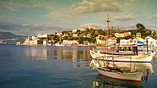
Kastellorizo or Castellorizo, officially Megisti, is a Greek island and municipality of the Dodecanese in the Eastern Mediterranean. It lies roughly 2 kilometres off the south coast of Turkey, about 570 km (354 mi) southeast of Athens and 125 km (78 mi) east of Rhodes, almost halfway between Rhodes and Antalya, and 280 km (170 mi) northwest of Cyprus. Kastellorizo is part of the Rhodes regional unit.

Paxos is a Greek island in the Ionian Sea, lying just south of Corfu. As a group with the nearby island of Antipaxos and adjoining islets, it is also called by the plural form Paxi or Paxoi. The main town and the seat of the municipality is Gaios. The smallest of the seven main Ionian Islands, Paxos has an area of 25.3 square kilometres (9.8 sq mi), while the municipality has an area of 30.121 km2 (11.630 sq mi) and a population of about 2,500.
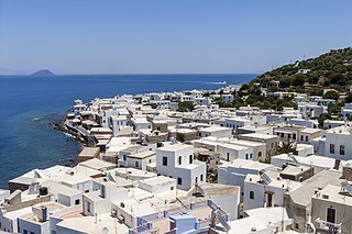
Nisyros also spelled Nisiros is a volcanic Greek island and municipality located in the Aegean Sea. It is part of the Dodecanese group of islands, situated between the islands of Kos and Tilos.

Spetses is an island in Attica, Greece. It is counted among the Saronic Islands group. Until 1948, it was part of the old prefecture of Argolis and Corinthia Prefecture, which is now split into Argolis and Corinthia. In ancient times, it was known as Pityussa.

Skiathos is a small Greek island in the northwest Aegean Sea. Skiathos is the westernmost island in the Northern Sporades archipelago, east of the Pelion peninsula in Magnesia on the mainland, and west of the island of Skopelos.

Kea, also known as Tzia and in antiquity Keos, is a Greek island in the Cyclades archipelago in the Aegean Sea. Kea is part of the Kea-Kythnos regional unit.

Alonnisos, also transliterated as Alonissos, is a Greek island in the Aegean Sea. After Skiathos and Skopelos it is the third member of the Northern Sporades. It is 3 km (2 mi) (2 nm) east of the island of Skopelos. Alonnisos is also the name of a village on the island, as well as the municipality that encompasses the island and the village.
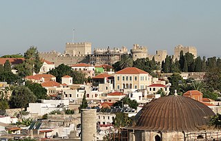
Rhodes is the principal city and a former municipality on the island of Rhodes in the Dodecanese, Greece. Since the 2011 local government reform, it is part of the municipality Rhodes, of which it is the seat and a municipal unit. It has a population of approximately 56,000 inhabitants. Rhodes has been famous since antiquity as the site of Colossus of Rhodes, one of the Seven Wonders of the Ancient World. The citadel of Rhodes, built by the Hospitalliers, is one of the best-preserved medieval towns in Europe. The Medieval city is designated as a UNESCO World Heritage Site.

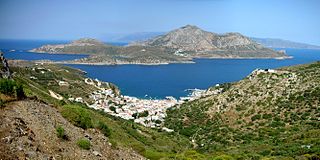
Fournoi Korseon, more commonly simply Fournoi, anciently known as Corsiae or Korsiai, Corseae or Korseai (Κορσεαί), Corsia or Korsia (Κορσία), and Corassiae (Κορασσίαι), form a complex or archipelago of small Greek islands that lie between Ikaria, Samos and Patmos in Ikaria regional unit, North Aegean region. The two largest islands of the complex, the main isle of Fournoi 31 square kilometres and the isle of Thymaina 10 square kilometres, are inhabited, as is Agios Minas Island 2.3 square kilometres to the east. The municipality has an area of 45.247 km2. On the main isle Fournoi (town) is the largest settlement and then Chrysomilia in the north the second largest. Fournoi (town) proper is the main ferry harbour, with ferries also landing on Thymaina.

Kythnos, commonly called Thermia, is a Greek island and municipality in the Western Cyclades between Kea and Serifos. It is 56 nautical miles (104 km) from the Athenian harbor of Piraeus. The municipality Kythnos is 100.187 km2 (38.68 sq mi) in area and has a coastline of about 100 km (62 mi). Mount Kakovolo is island's highest peak (365m).
Nisaki is a small sea-side village in north-east Corfu, Greece. It was named after the small island in its bay. During the 20th century, probably with the advent of mass tourism, several tavernas were built on this islet and a jetty was constructed, linking it permanently to the mainland. The main village of Nisaki grew up on the hill above this inlet where a church, school, cafe and many other buildings are located.

Agathonísi is a small Greek island and municipality located at the northernmost point of the Dodecanese in Greece. It is surrounded by many smaller islands and is home to two villages, both inland; Megalo Chorio, and Mikro Chorio. Between them is the small settlement of Agios Georgios, which forms the island's only harbor and consists of a few hotels and restaurants. The island is also locally known as Gaidaro ("Donkey"), or by its ancient name Tragea.

Irakleia or Heraklia is an island and a former community in the Cyclades, Greece. Since the 2011 local government reform it is part of the municipality Naxos and Lesser Cyclades, of which it is a municipal unit. Its population was officially 148 inhabitants at the 2021 census, and its land area 17.795 square kilometres (6.9 sq mi). It is a small island between the islands of Naxos and Ios. Close to Schoinoussa, Koufonisi, Donoussa, and Keros, together they form the Lesser Cyclades. The port is called Agios Georgios, while the "capital"/chora on the top of the island is called Panagia (Madonna). The biggest caves in the Cyclades are located on Irakleia. Irakleia can be reached by ferries from Athens, Naxos and Paros.

Koufonisia is a former community in the Cyclades, Greece. Since the 2011 local government reform it is part of the municipality Naxos and Lesser Cyclades, of which it is a municipal unit. The municipal unit has an area of 26.025 km2.
Thymaina is a small Greek island in the Ikaria regional unit, in the eastern Aegean Sea. Thymaina is located just west of Fournoi Korseon and is administratively a part of its municipality. Its name is said to be derived from the thyme that grows throughout the island. Thymaina has two settlements, Thymaina settlement and Keramidou. The population of the island is 191 inhabitants according to the 2021 census, 179 in Thymaina settlement and 12 in Kerameidou. The area is 10 square kilometres (4 sq mi). Thymaina is a protected area along with all Fournoi cluster and belongs to the network Natura 2000.

The siege of Rhodes was a military engagement involving the Knights Hospitaller and Mamluk Sultanate. The Mamluk fleet landed on the island of Rhodes on 10 August 1444, besieging its citadel. Clashes took place on the western walls of the city and at the Mandraki harbor. On 18 September 1444, the Mamluks departed from the island and lifted the siege.