Mank, Austria

Last updated
Mank
Kirche Rathaus 2019.jpg
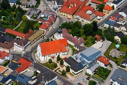
Aerial view of the church and town hall
AUT Mank COA.jpg
Austria adm location map.svg
Red pog.svg
Mank
Location within Austria
Coordinates: 48°7′N15°20′E / 48.117°N 15.333°E / 48.117; 15.333 Coordinates: 48°7′N15°20′E / 48.117°N 15.333°E / 48.117; 15.333
Country Austria
State Lower Austria
District Melk
Government
   Mayor Martin Leonhardsberger (ÖVP)
Area
[1]
  Total33.38 km2 (12.89 sq mi)
Elevation
295 m (968 ft)
Population
 (2018-01-01) [2]
  Total3,219
  Density96/km2 (250/sq mi)
Time zone UTC+1 (CET)
  Summer (DST) UTC+2 (CEST)
Postal code
3240
Area code 02755
Website www.mank.at

Mank is a town in the district of Melk in the Austrian state of Lower Austria.

Population

Historical population
YearPop.±%
18691,829    
18802,046+11.9%
18902,170+6.1%
19002,371+9.3%
19102,513+6.0%
19232,504−0.4%
19342,575+2.8%
19392,521−2.1%
19512,517−0.2%
19612,528+0.4%
19712,653+4.9%
19812,664+0.4%
19912,684+0.8%
20012,904+8.2%
20113,047+4.9%

Related Research Articles

Wolfurt Place in Vorarlberg, Austria

Wolfurt is a municipality in the western Austrian state of Vorarlberg.

Satteins Place in Vorarlberg, Austria

Satteins is a town in the Austrian state of Vorarlberg.

Nenzing Place in Vorarlberg, Austria

Nenzing is a market town in the district of Bludenz in the Austrian state of Vorarlberg.

Bartholomäberg Place in Vorarlberg, Austria

Bartholomäberg is a municipality and popular tourism resort in the district of Bludenz in the Austrian state of Vorarlberg.

Bildstein Place in Vorarlberg, Austria

Bildstein is a municipality in the district of Bregenz in the Austrian state of Vorarlberg.

Ludesch Place in Vorarlberg, Austria

Ludesch is a municipality in the district of Bludenz in the Austrian state of Vorarlberg.

Nüziders Place in Vorarlberg, Austria

Nüziders is a municipality in the district of Bludenz in the Austrian state of Vorarlberg. It was capital of the historical County of Sonnenberg which is referred to in the formal style of the Emperor of Austria.

Raggal Place in Vorarlberg, Austria

Raggal is a municipality in the district of Bludenz in the Austrian state of Vorarlberg.

Sonntag, Austria Place in Vorarlberg, Austria

Sonntag is a municipality in the district of Bludenz in the Austrian state of Vorarlberg.

Thüringerberg Place in Vorarlberg, Austria

Thüringerberg is a municipality in the district of Bludenz in the Austrian state of Vorarlberg.

Fußach Place in Vorarlberg, Austria

Fußach is a municipality in the district of Bregenz in the Austrian state of Vorarlberg.

Gaißau Place in Vorarlberg, Austria

Gaißau is a municipality in the district of Bregenz in the Austrian state of Vorarlberg.

Höchst, Austria Place in Vorarlberg, Austria

Höchst is a municipality in the district of Bregenz in the Austrian state of Vorarlberg.

Langen bei Bregenz Place in Vorarlberg, Austria

Langen bei Bregenz is a municipality in the district of Bregenz in the Austrian state of Vorarlberg.

Schnepfau Place in Vorarlberg, Austria

Schnepfau is a municipality in the district of Bregenz in the Austrian state of Vorarlberg.

Düns Place in Vorarlberg, Austria

Düns is a municipality in the district of Feldkirch in the Austrian state of Vorarlberg.

Mäder Place in Vorarlberg, Austria

Mäder is a municipality in the district of Feldkirch in the Austrian state of Vorarlberg.

Schlins Place in Vorarlberg, Austria

Schlins is a municipality in the district of Feldkirch in the Austrian state of Vorarlberg.

Altschwendt Place in Upper Austria, Austria

Altschwendt is a municipality in the district of Schärding in the Austrian state of Upper Austria.

Bad Waltersdorf Place in Styria, Austria

Bad Waltersdorf is a municipality in the district of Hartberg-Fürstenfeld in Styria, Austria.

References

  1. "Dauersiedlungsraum der Gemeinden Politischen Bezirke und Bundesländer - Gebietsstand 1.1.2018". Statistics Austria. Retrieved 10 March 2019.
  2. "Einwohnerzahl 1.1.2018 nach Gemeinden mit Status, Gebietsstand 1.1.2018". Statistics Austria. Retrieved 9 March 2019.