Bath and North East Somerset (B&NES) is a unitary authority district in Somerset, South West England. Bath and North East Somerset Council was created on 1 April 1996 following the abolition of the county of Avon. It is part of the ceremonial county of Somerset.

Keynsham is a town and civil parish located on the outskirts of the city of Bristol on the A4 that links the cities of Bristol and Bath in Somerset, England. It had a population of 19,603 at the 2021 Census. It was listed in the Domesday Book as Cainesham, which is believed to mean the home of Saint Keyne.

Chew Magna is a village and civil parish within the Chew Valley in the unitary authority of Bath and North East Somerset, in the ceremonial county of Somerset, England. The parish has a population of 1,149.
Chew Stoke is a small village and civil parish in the affluent Chew Valley, in Somerset, England, about 8 miles (13 km) south of Bristol and 10 miles north of Wells. It is at the northern edge of the Mendip Hills, a region designated by the United Kingdom as an Area of Outstanding Natural Beauty, and is within the Bristol and Bath green belt. The parish includes the hamlet of Breach Hill, which is approximately 2 miles (3.2 km) southwest of Chew Stoke itself.
Brislington is an area in the south east of the city of Bristol, England. It is on the edge of Bristol and 10 miles (16 km) from Bath. Brislington Brook runs through the area in the woodlands of Nightingale Valley and St Anne's Wood. Brislington formerly housed the HTV West Studios on Bath Road, and this is situated next to the historic Arnos Vale Cemetery. Other notable landmarks include Brislington House and the 15th-century St Luke's Church. During the 18th–19th century, Brislington was regarded as a picturesque country village and contained many country homes.

Blagdon is a village and civil parish in the ceremonial county of Somerset, within the unitary authority of North Somerset, in England. It is located in the Mendip Hills, a recognised Area of Outstanding Natural Beauty. According to the 2021 census it has a population of 1,184. The village is about 12 miles (19 km) east of Weston-super-Mare and 12 miles (19 km) south west of Bristol, on the A368 road to Bath.

Bishop Sutton is a village on the northern slopes of the Mendip Hills, within the affluent Chew Valley in Somerset. It lies east of Chew Valley Lake and north east of the Mendip Hills, approximately ten miles south of Bristol on the A368, Weston-super-Mare to Bath road. Bishop Sutton and the neighbouring village of Stowey form the civil parish of Stowey Sutton.

Compton Martin is a small village and civil parish within the Chew Valley in Somerset and in the Bath and North East Somerset unitary authority in England. The parish has a population of 508. It lies between Chew Valley Lake and Blagdon Lake, north of the Mendip Hills, approximately 10 miles (16 km) south of Bristol on the A368 road Weston-super-Mare to Bath.
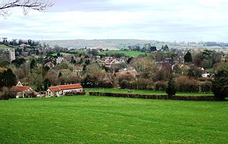
The Chew Valley is an affluent area in North Somerset, England, named after the River Chew, which rises at Chewton Mendip, and joins the River Avon at Keynsham. Technically, the area of the valley is bounded by the water catchment area of the Chew and its tributaries; however, the name Chew Valley is often used less formally to cover other nearby areas, for example, Blagdon Lake and its environs, which by a stricter definition are part of the Yeo Valley. The valley is an area of rich arable and dairy farmland, interspersed with a number of villages.

Chelwood is a small village and civil parish in Somerset, England, and is in the Chew Valley in the Bath and North East Somerset council area, about 8 miles (13 km) from Bristol and Bath. The parish, which includes the hamlets of West Chelwood and Breach, has a population of 148. It is situated on the A368, very close to the A37.

Ubley is a small village and civil parish within the Chew Valley in Bath and North East Somerset about 9 miles (14.5 km) south of Bristol. It is just south-east of Blagdon Lake, just off the A368 between Compton Martin and Blagdon.

Norton Malreward is a small Somerset village and civil parish 4 miles (6.4 km) south of Bristol, England at the northern edge of the Chew Valley. In 1895 Norton Malreward was combined with the neighbouring hamlet of Norton Hawkfield into a single parish, which has a population of 246.

Chewton Keynsham is a hamlet on the River Chew in the Chew Valley, Somerset, England. It is 7 miles from Bristol, 7 miles from Bath, and 2 miles (3.2 km) south of the centre of the town of Keynsham.

Stowey is a small village and former civil parish, now in the parish of Stowey Sutton, in the Bath and North East Somerset district, in the ceremonial county of Somerset, England. It lies within the Chew Valley, south of Chew Valley Lake and north of the Mendip Hills, approximately 10 miles (16 km) south of Bristol on the A368 road Weston-super-Mare to Bath. Stowey and its neighbouring and larger village, Bishop Sutton, form the civil parish of Stowey Sutton.
Hunstrete is a small village on the River Chew in the Chew Valley, Bath and North East Somerset, England. It falls within the civil parish of Marksbury and is 8 miles (13 km) from Bath and Bristol, and 5 miles (8 km) from Keynsham. It is just off the A368 between Marksbury and Chelwood.
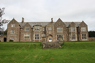
Sutton Court is an English house remodelled by Thomas Henry Wyatt in the 1850s from a manor house built in the 15th and 16th centuries around a 14th-century fortified pele tower and surrounding buildings. The house has been designated as Grade II* listed building.

Burnett is a small village within the civil parish of Compton Dando, approximately 500 metres (1,600 ft) from the River Chew in the Chew Valley within the unitary authority area of Bath and North East Somerset in Somerset, England. The nearest town is Keynsham, which lies approximately 3 miles (4.8 km) north of the village. The parish had an acreage of 608 acres (246 ha). It is within the Bristol/Bath Green Belt.

Chew Court is a Grade II* listed building next to St Andrew's church in Chew Magna, Somerset, England.

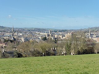
Bath and North East Somerset is a unitary authority created on 1 April 1996, following the abolition of the County of Avon, which had existed since 1974. Part of the ceremonial county of Somerset, Bath and North East Somerset occupies an area of 220 square miles (570 km2), two-thirds of which is green belt. It stretches from the outskirts of Bristol, south into the Mendip Hills and east to the southern Cotswold Hills and Wiltshire border. The city of Bath is the principal settlement in the district, but BANES also covers Keynsham, Midsomer Norton, Radstock and the Chew Valley. The area has a population of 170,000, about half of whom live in Bath, making it 12 times more densely populated than the rest of the area.
