
Oxford is a city in England. It is the county town and only city of Oxfordshire. In 2017, its population was estimated at 152,450. It is 56 miles (90 km) northwest of London, 64 miles (103 km) southeast of Birmingham, and 61 miles (98 km) northeast of Bristol.
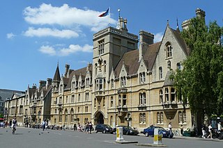
Balliol College is one of the constituent colleges of the University of Oxford in England. One of Oxford's oldest colleges, it was founded around 1263 by John I de Balliol, a rich landowner from Barnard Castle in County Durham, who provided the foundation and endowment for the college. When de Balliol died in 1268 his widow, Dervorguilla, a woman whose wealth far exceeded that of her husband, continued his work in setting up the college, providing a further endowment and writing the statutes. She is considered a co‑founder of the college.

Broad Street is a wide street in central Oxford, England, just north of the former city wall. The street is known for its bookshops, including the original Blackwell's bookshop at number 50, located here due to the University of Oxford. Among residents, the street is traditionally known as The Broad.
South Parks Road is a road in Oxford, England. It runs east–west past the main Science Area of the University of Oxford. Many of the university science departments are located nearby or face the road, including parts of the geography, zoology, chemistry, psychology and physiology departments. Also on the road is Rhodes House.

Parks Road is a road in Oxford, England, with several Oxford University colleges along its route. It runs north–south from the Banbury Road and Norham Gardens at the northern end, where it continues into Bradmore Road, to the junction with Broad Street, Holywell Street and Catte Street to the south.

Holywell Street is a street in central Oxford, England. It runs east-west with Broad Street to the west and Longwall Street to the east. About halfway along, Mansfield Road adjoins to the north.
St Cross Road is a road in Oxford, England. It links South Parks Road to the north and Longwall Street to the south, where it also meets Holywell Street. The road is named after St Cross Church.

Keble Road is a short road running east–west in central Oxford, England. To the west is the southern end of the Banbury Road with St Giles' Church opposite. To the east is Parks Road with the University Parks opposite. Blackhall Road leads off the road to the south near the western end.
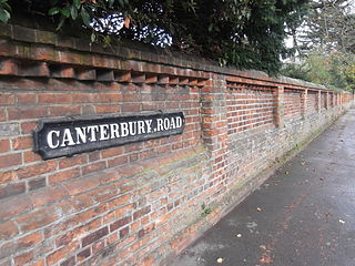
Canterbury Road is a road in North Oxford, England. It runs between Woodstock Road to the west and Banbury Road to the east. Winchester Road leads south from halfway along Canterbury Road, linking with Bevington Road that runs parallel to the south. Also to the south are North Parade and Church Walk.

Catte Street is a historic street in central Oxford, England.

St Margaret's Road is a road in North Oxford, England.
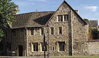
Holywell Manor is a historic building in central Oxford, England, in the parish of Holywell. It currently houses some of Balliol College's postgraduate student population. It is on the corner of Manor Road and St Cross Road, next to St Cross Church, which has become the Balliol College Historic Collections Centre.
Jowett Walk is a road in central Oxford, England. It connects Mansfield Road to the west with St Cross Road to the east, running parallel with and north of Holywell Street.
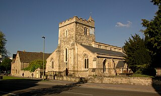
St Cross Church is a former church, now a historic collections centre, in Oxford, England, to the northeast of the centre of the city. The church is on St Cross Road at the junction with Manor Road, just south of Holywell Manor. Also close by is Holywell Cemetery.

Rawlinson Road is a residential road in North Oxford, England.

Blackhall Road is a road running between Keble Road to the north and Museum Road to the south in central Oxford, England, dating from the late 19th century. It is named after Black Hall, dating from at least 1519, fronting onto St Giles', and now part of St John's College. Houses in the road were leased by St John's College between 1865–75.

Crick Road is a road in North Oxford, England, an area characterised by large Victorian Gothic villas.
The School of Geography and the Environment (SoGE) is a department of the University of Oxford in England, which is part of the university's Social Sciences Division. It is located in the Oxford University Centre for the Environment on South Parks Road, in central Oxford.
Manor Road is a road in central Oxford, England. It is a no through road that links St Cross Road to the west with St Catherine's College, one of the newer Oxford colleges, to the east. The road crosses the Holywell Mill Stream.

The Holywell Music Room is the city of Oxford's chamber music hall, situated on Holywell Street in the city centre, and is part of Wadham College. It is said to be the oldest purpose-built music room in Europe, and hence Britain's first concert hall.


