
Mpumalanga is a province of South Africa. The name means "East", or literally "The Place Where the Sun Rises" in the Nguni languages. Mpumalanga lies in eastern South Africa, bordering Eswatini and Mozambique. It shares borders with the South African provinces of Limpopo to the north, Gauteng to the west, the Free State to the southwest, and KwaZulu-Natal to the south. The capital is Mbombela.

Limpopo is the northernmost province of South Africa. It is named after the Limpopo River, which forms the province's western and northern borders. The capital and largest city in the province is Polokwane, while the provincial legislature is situated in Lebowakgomo.

iSimangaliso Wetland Park is situated on the east coast of KwaZulu-Natal, South Africa, about 235 km (146 mi) north of Durban by road. It is South Africa's third-largest protected area, spanning 280 km (170 mi) of coastline, from the Mozambican border in the north to Mapelane south of the Lake St. Lucia estuary, and made up of around 3,280 km2 of natural ecosystems, managed by the iSimangaliso Authority. The park includes:
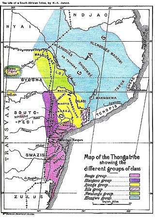
The Tsonga people are a Bantu ethnic group primarily native to Southern Mozambique and South Africa. They speak Xitsonga, a Southern Bantu language. A very small number of Tsonga people are also found in Zimbabwe and Northern Eswatini. The Tsonga people of South Africa share some history with the Tsonga people of Southern Mozambique, and have similar cultural practices, but differ in the dialects spoken.

James Stevenson-Hamilton served from 1902–1946 as the first warden of South Africa's Sabi Nature Reserve, which was expanded under his watch and became Kruger National Park in 1926. The Tsonga people nicknamed him Skukuza because when he arrived at the area of the reserve he "turned everything upside down" with the banning of all hunting in the reserve and the relocation of all the native kraals. Skukuza camp and Skukuza Airport is named in honour of Stevenson-Hamilton, who is regarded as a champion of wildlife Conservation in South Africa.

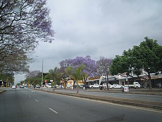
Hazyview is a sub-tropical farming town in Mpumalanga, South Africa, renowned for its large banana and macadamia nut industries, contributing about 20% of South Africa's bananas and 30% of macadamia output. Bordering the Kruger National Park, the town's name is derived from the shimmering haze that occurs during the heat of summer. Most of the province of Mpumalanga's private game reserves are found just east of Hazyview.
White River is a small holiday and farming town situated just north of Mbombela in Mpumalanga, South Africa. The farms in the region produce tropical fruits, macadamia nuts, vegetables, flowers and timber. As of 2011, White River had a population of 16,639.

Gazankulu was a bantustan in South Africa, intended by the apartheid government to be a semi-independent homeland for the Tsonga people. It was located in both the Northern Transvaal, now Limpopo province and Eastern Transvaal, now Mpumalanga province.
The Kingdom of Mapungubwe was a medieval state in South Africa located at the confluence of the Shashe and Limpopo rivers, south of Great Zimbabwe. The name is derived from either TjiKalanga and Tshivenda. The name might mean "Hill of Jackals" or "stone monuments". The kingdom was the first stage in a development that would culminate in the creation of the Kingdom of Zimbabwe in the 13th century, and with gold trading links to Rhapta and Kilwa Kisiwani on the African east coast. The Kingdom of Mapungubwe lasted about 140 years, and at its height the capital's population was about 5000 people.
South African Bantu-speaking peoples represent the majority of people in South Africa and who have lived in what is now South Africa for thousands of years as an indigenous people alongside other indigenous groups like Khoisans. Occasionally grouped as Bantu, the term itself is derived from the English word "people", common to many of the Bantu languages. The Oxford Dictionary of South African English describes "Bantu", when used in a contemporary usage or racial context as "obsolescent and offensive", because of its strong association with the "white minority rule" with their Apartheid system. However, Bantu is used without pejorative connotations in other parts of Africa and is still used in South Africa as the group term for the language family.
The Chopi are an ethnic group of Mozambique. They have lived primarily in the Zavala region of southern Mozambique, in the Inhambane Province. They traditionally lived a life of subsistence agriculture, traditionally living a rural existence, although many were displaced or killed in the civil war that followed Mozambique's liberation from Portuguese colonial rule in 1975. In addition, drought forced many away from their homeland and into the nation's cities.

Mala Mala is a game reserve located within the Sabi Sand Game Reserve, Mpumalanga province, South Africa. It is the largest and the oldest private big five game reserve in South Africa, It covers around 130 km2 or 15 000 hectares of land. In Xitsonga, the name Malamala means Kudu, it was named so because of the abundance of these animals within the game reserve. The Tsonga people, who occupied the land before the establishment of the game reserve, were forcibly removed from this land during the early 1900s and were dumped at Bushbuckridge. The Nwandlamhlarhi Community successfully claimed Malamala game reserve and the land was restored to them in 2015 when President Jacob Zuma handed them their land in a Government ceremony. The Tsonga people were also forcibly removed from neighbouring game reserves such as Skukuza, Satara, Ulusaba, Manyeleti, Protea Hotel Kruger Gate, Hoyo Hoyo Tsonga Lodge and may more in Southern Kruger. The Tsonga people are still waiting to be given back these lands by the Government after the finalization of their land claim.
The Tonga people of Zambia and Zimbabwe are a Bantu ethnic group of southern Zambia and neighbouring northern Zimbabwe, and to a lesser extent, in Mozambique. They are related to the Batoka who are part of the Tokaleya people in the same area, but not to the Tonga people of Malawi. In southern Zambia they are patrons of the Kafue Twa. They differ culturally and linguistically from the Tsonga people of South Africa and southern Mozambique.

The Timbavati Private Nature Reserve is located at the border line between Hoedspruit and Acornhoek, north of the Sabi Sand Private Game Reserve on the western edge of Kruger National Park. Geographically and politically, Timbavati is located in Mpumalanga Province. In Xitsonga, the name 'Timbavati' means "the place where something sacred came down to Earth from the Heavens", and refers to the rare white lions of Timbavati.

The Makuleke are a Tsonga tribe living in the Pafuri Triangle of South Africa at the confluence of the Luvuvhu river and Limpopo river in what is now the Kruger National Park. The Tsonga-speaking agricultural and fishing tribe settled the area in the seventeenth century with decentralized homesteads. When the park was created they were exiled outside the gates, but had title to their lands restored as part of post-apartheid restitution laws. There are about 12,000 members of the clan and they are part of an eco-tourism economic development with the land they received from the park.

Ulusaba Private Game Reserve, owned by Sir Richard Branson as part of the Virgin Limited Edition luxury property portfolio, consists of about 13,500 ha of land set in the heart of the Sabi Sand Private Game Reserve. This private game reserve borders on the sprawling Kruger National Park in South Africa's Mpumalanga province and is home to an abundance of wildlife. Ulusaba means fearful in the local Tsonga (Shangaan) language and it was a name given to the Sabie River by the Shangaan people. The Sabie River was originally called Ulusaba by the Shangaan simply because there was once a large concentration of dangerous Nile crocodile in the river. Before the establishment of the Kruger National Park, Ulusaba was once a home of Tsonga-Shangaan people, the Shangaan were evicted from this land when the Kruger National Park was established and were relocated in nearby villages adjacent Ulusaba Private Game Reserve.
Bushbuckridge Municipality is a local municipality within the Ehlanzeni District Municipality, in the Mpumalanga province of South Africa. Commercial farming, which consists of pine and bluegum plantations, tobacco, cotton, sub-tropical fruits and vegetables is practised in the municipality's countryside. The municipality includes the southern part of the Kruger National Park. Bushbuckridge is the largest local municipality in Mpumalanga in terms of land size.
Sekhukhuneland or Sekukuniland is a natural region in north-east South Africa, located in the historical Transvaal zone, former Transvaal Province, also known as Bopedi. The region is named after the 19th-century King, Sekhukhune I.
The R531 is a Regional Route in South Africa.
Hluvukani is a Tsonga speaking town in Bushbuckridge Local Municipality, Mpumalanga. It lies south of the R531 and west of the Manyeleti Game Reserve. It had a population of 9,631 in 2011. The Hluvukani Animal Clinic, a satellite of the University of Pretoria Faculty of Veterinary Science operates from the town.
