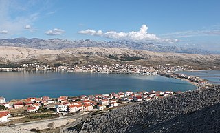
Pag is the largest town on the island of Pag, with a population of 2,343 (2021) in the urban core and 3,178 in the entire municipality.

Vrlika is a small town in inland Split-Dalmatia County, Croatia. The closest large towns are Sinj, Knin, and Drniš. Vrlika was given the status of town in 1997. Vrlika is an underdeveloped municipality which is statistically classified as the First Category Area of Special State Concern by the Government of Croatia.

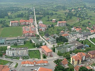
Slunj is a town in the mountainous part of Central Croatia, located along the important North-South route to the Adriatic Sea between Karlovac and Plitvice Lakes National Park, on the meeting of the rivers Korana and Slunjčica. Slunj has a population of 1,674, with a total of 5,076 people in the municipality (2011) and is the cultural and social center of the region of Kordun in the vicinity to Bosnia and Herzegovina. Administratively, the town is part of Karlovac County. Slunj is an underdeveloped municipality which is statistically classified as part of the First Category Area of Special State Concern by the Government of Croatia.
Kalesija is a town and municipality located in Tuzla Canton of the Federation of Bosnia and Herzegovina, an entity of Bosnia and Herzegovina. It is located in northeastern Bosnia and Herzegovina, east of Tuzla. As of 2013, the town has a population of 2,039 inhabitants, and the municipality has 33,053 inhabitants.

Benkovac is a town and municipality in the Zadar County, Croatia.
Škabrnja is a village in northern Dalmatia, Croatia, located halfway between Zadar and Benkovac in the lowland region of Ravni Kotari. Its municipality is also called Škabrnja, and it includes Škabrnja with a population of 1,413 as well as the smaller village of Prkos, population 363 with a total of 1,776 residents. The total area of the municipality is 22.93 km2.

Šolta is an island in Croatia. It is situated in the Adriatic Sea in the central Dalmatian archipelago.
Unešić is a municipality in Šibenik-Knin County, Croatia.
Hrvace is a village and a municipality in Croatia in the Split-Dalmatia County.

Duga Resa is a town in Karlovac County, Croatia. It is located about 65 km southwest of Zagreb and 100 km east of Rijeka.

The history of Zagreb, the capital and largest city of Croatia, dates back to the Middle Ages. The Romans had built a settlement, Andautonia, in present-day Ščitarjevo. The name "Zagreb" was first used in 1094 at the founding of the Zagreb diocese in Kaptol, after the Slavs had arrived in the area. Zagreb became a free royal city in 1242. It was made the capital of Croatia in 1845 and elected its first mayor, Janko Kamauf, in 1851. According to the 2011 Croatian census, Zagreb had 792,875 inhabitants and was also Croatia's largest city by area.

Novi Sad is the second largest city of Serbia. It began as a Stone Age settlement in present-day Petrovaradin. The Celts founded the first fortress at this location. During Roman rule, a larger fortress was built in the 1st century AD. It was devastated by the Huns in the 5th century and rebuilt by the Byzantines. The city passed through many other hands until being conquered by the Kingdom of Hungary. The city was first mentioned under the name Peturwarad or Petrovaradin in documents from 1237. It passed through the Ottoman Empire in the 16th century and the Habsburg monarchy in the 17th.
Muć is a village and a municipality in Croatia. It is part of the Split-Dalmatia County, located in the Zagora region near Sinj.

Svilaja is a mountain range in Croatia, in the Dalmatian Hinterland.

The Church of the Holy Salvation or Holy Saviour was a Pre-Romanesque church in the Dalmatian Hinterland, Croatia, whose ruins are now a historic site. It is located in the small village of Cetina, near the spring of the river Cetina, 8 km northwest from the town of Vrlika.
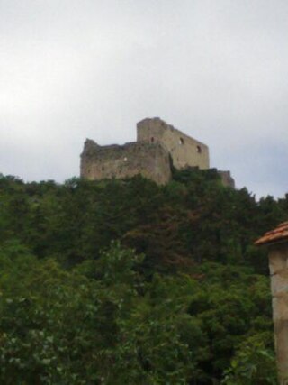
Prozor Fortress is a medieval fortress situated in the continental part of Split-Dalmatia County, in inland Dalmatia, just above the town of Vrlika in Croatia. From its origin as a small stronghold built by the ancient Illyrian tribe Dalmatae, it developed into a fortress in the 15th century, during the reign of Bosnian feudal lord Hrvoje Vukčić Hrvatinić.
Otišić is a small village in the Split-Dalmatia County, Croatia. Located in inland Dalmatia, south of Vrlika, on the State route D1 between towns of Sinj and Vrlika. Otišić is a settlement in the Vrlika municipality, with a population of about 20, the majority of whom are ethnic Serbs. The 1991 census, held before the War in Croatia (1991–1995), registered Otišić with a population of 1,006, out of which 996 were ethnic Serbs. During the War, the village was held by the Republic of Serb Krajina. In 2007, the settlement, which had up until then been a part of Sinj, was joined into Vrlika. Otišić spreads on 51.01 km2, between mountain Svilaja on the southwest and 25-km long Peruća Lake - Power Plant Accumulation on the northeast. There are the following hamlets or geographical parts of the village: Draga Otišićka, Gaj, Poljana, Ječmište, Krivošija, Dubrava, Ograde, Poljice Otišićko, Rudopolje Sinjsko, Svilaja, Ševina Njiva, Tavan, and Vlake.
Cetina is a small village, administratively located in the Civljane Municipality in Šibenik-Knin County, Croatia. According to the 2011 census, the village had 195 inhabitants.
Koljane is a small village in Split-Dalmatia County, Croatia. Koljane is a settlement in the Vrlika municipality, and the majority of the population are Croats. In the 1991 census, the population of Koljane was 285, and the majority were Serbs with 90% (257).

Pitve is a settlement on the island of Hvar, in the district of Jelsa. It lies 168 metres above sea-level on the northern side of the island, in the hills above Jelsa.
