Maple Cross and Mill End

Last updated

Coordinates: 51°38′02″N0°29′31″W / 51.634°N 0.492°W / 51.634; -0.492

Geographic coordinate system Coordinate system

A geographic coordinate system is a coordinate system that enables every location on Earth to be specified by a set of numbers, letters or symbols. The coordinates are often chosen such that one of the numbers represents a vertical position and two or three of the numbers represent a horizontal position; alternatively, a geographic position may be expressed in a combined three-dimensional Cartesian vector. A common choice of coordinates is latitude, longitude and elevation. To specify a location on a plane requires a map projection.

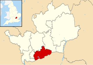
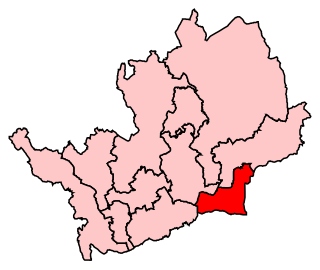
Maple Cross and Mill End is a ward in Three Rivers, in England, the United Kingdom. It is located in the far south-west Hertfordshire, in the East of England region. The ward includes the eponymous villages of Maple Cross and Mill End, lying between Chorleywood West to the north; Penn, Rickmansworth, and Harefield to the east; and Chalfont St. Giles and Chalfont Common to the west.

England Country in north-west Europe, part of the United Kingdom

England is a country that is part of the United Kingdom. It shares land borders with Wales to the west and Scotland to the north-northwest. The Irish Sea lies west of England and the Celtic Sea lies to the southwest. England is separated from continental Europe by the North Sea to the east and the English Channel to the south. The country covers five-eighths of the island of Great Britain, which lies in the North Atlantic, and includes over 100 smaller islands, such as the Isles of Scilly and the Isle of Wight.

United Kingdom Country in Europe

The United Kingdom (UK), officially the United Kingdom of Great Britain and Northern Ireland, and sometimes referred to as Britain, is a sovereign country located off the north-western coast of the European mainland. The United Kingdom includes the island of Great Britain, the north-eastern part of the island of Ireland, and many smaller islands. Northern Ireland is the only part of the United Kingdom that shares a land border with another sovereign state, the Republic of Ireland. Apart from this land border, the United Kingdom is surrounded by the Atlantic Ocean, with the North Sea to the east, the English Channel to the south and the Celtic Sea to the south-west, giving it the 12th-longest coastline in the world. The Irish Sea lies between Great Britain and Ireland. With an area of 242,500 square kilometres (93,600 sq mi), the United Kingdom is the 78th-largest sovereign state in the world. It is also the 22nd-most populous country, with an estimated 66.0 million inhabitants in 2017.

East of England Place in England

The East of England is one of nine official regions of England at the first level of NUTS for statistical purposes. It was created in 1994 and was adopted for statistics from 1999. It includes the ceremonial counties of Bedfordshire, Cambridgeshire, Essex, Hertfordshire, Norfolk and Suffolk. Essex has the highest population in the region.

As one of the more populous wards in the district, with an electorate of 3,931, including West Hyde and increasing to 5,602 at the 2011 Census, [1] the ward elects three members to Three Rivers District Council. country. For elections to Hertfordshire County Council, Maple Cross and Mill End is part of the Rickmansworth constituency, represented by the Conservative Barbara Lamb. For elections to the House of Commons, it is in the South West Hertfordshire constituency, represented by David Gauke, also of the Conservatives.

West Hyde

West Hyde is a village situated alongside the A412 road, in the Three Rivers District in south-west Hertfordshire, England. At the 2011 the population of the village was included in the Three Rivers ward of Maple Cross and Mill End.

Three Rivers District Council

Three Rivers District Council is the local authority for the Three Rivers non-metropolitan district of England, the United Kingdom. Three Rivers is located in the south-west of Hertfordshire, in the East of England region. The Council itself is based in Rickmansworth, the largest settlement in the district, but also comprises Abbots Langley, Chorleywood, Croxley Green, Maple Cross, Mill End, Sarratt and South Oxhey.

Hertfordshire County Council British administrative body

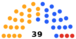
Hertfordshire County Council is the upper-tier local authority for the non-metropolitan county of Hertfordshire, in England, the United Kingdom. After the elections in 2017, it consists of 78 councillors, and is controlled by the Conservative Party, which has 50 councillors, versus 19 Liberal Democrats and 9 Labour councillors. It is a member of the East of England Local Government Association.

Related Research Articles

Welwyn Hatfield Borough & Non-metropolitan district in England

The Borough of Welwyn Hatfield is a local government district in southern Hertfordshire, England.

Hertsmere Place in England

Hertsmere is a local government district and borough in Hertfordshire, England. Its council is based in Borehamwood. Other towns in the borough include Bushey, Elstree, Radlett and Potters Bar. The borough borders the three north London boroughs of Harrow, Barnet and Enfield, and is located mainly within the M25 Motorway.

Chorleywood village in the United Kingdom

Chorleywood is a village and civil parish in the Three Rivers District, Hertfordshire, England, in the far southwest of the county on the border with Buckinghamshire, approximately 20 miles (32 km) northwest of Charing Cross. It is part of the London commuter belt and included in the government-defined Greater London Urban Area. The parish of Chorleywood was created in 1845 from part of the parish of Rickmansworth. The parish had a population of 11,286 people at the 2011 census.

Broxbourne (UK Parliament constituency) Parliamentary constituency in the United Kingdom

Broxbourne is a constituency represented in the House of Commons of the UK Parliament since 2005 by Charles Walker of the Conservative Party.

Hemel Hempstead (UK Parliament constituency) Parliamentary constituency in the United Kingdom, 1997 onwards

Hemel Hempstead is a constituency represented in the House of Commons of the Parliament of the United Kingdom. It elects one Member of Parliament (MP) by the first past the post system of election.

North East Hertfordshire (UK Parliament constituency) Parliamentary constituency in the United Kingdom

North East Hertfordshire is a constituency represented in the House of Commons of the UK Parliament since 1997 by Oliver Heald, a Conservative.

South West Hertfordshire (UK Parliament constituency) Parliamentary constituency in the United Kingdom

South West Hertfordshire is a constituency represented in the House of Commons of the UK Parliament since 2005 by David Gauke, a Conservative.

Hitchin and Harpenden (UK Parliament constituency) Parliamentary constituency in the United Kingdom

Hitchin and Harpenden is a constituency represented in the House of Commons of the UK Parliament since 2017 by Bim Afolami, a Conservative.

Watford (UK Parliament constituency) Parliamentary constituency in the United Kingdom

Watford is a constituency represented in the House of Commons of the UK Parliament since 2010 by Richard Harrington, a member of the Conservative Party.

Chesham and Amersham (UK Parliament constituency) Parliamentary constituency in the United Kingdom

Chesham and Amersham is a parliamentary constituency represented in the House of Commons of the UK Parliament. The seat has been represented by Dame Cheryl Gillan of the Conservative Party since the 1992 general election.

Maple Cross village in Hertfordshire, England

Maple Cross is a village in Hertfordshire, England, which up until the Second World War consisted of an inn, a blacksmith's shop and a few cottages. Today there are around 800 postwar council houses. Some of these have been sold into private ownership. The area is close by junction 17 of the M25 motorway, which makes up the western boundary of the village. It lies on the western fringe of Rickmansworth, about 8 kilometres (5.0 mi) west of Watford and 6 miles north of Uxbridge.

Batchworth village in Hertfordshire, England

Batchworth was once a hamlet and is now a civil parish and part of Rickmansworth in Hertfordshire. Batchworth Parish Council was created in 2017 consisting of two Three Rivers District Council wards, namely, Rickmansworth Town and Moor Park & Eastbury. The first election was on 4 May 2017. There are eight councillors; four in each ward.

Moor Park and Eastbury is a ward in Three Rivers, in England. It is located in south-west Hertfordshire, in the East of England region. The ward includes the eponymous twin towns of Moor Park and Eastbury, lying between Rickmansworth to the west, Croxley Green to the north, South Oxhey to the east, and Northwood to the south.

Bedmond and Primrose Hill is a ward in Three Rivers, in England, the United Kingdom. It is located in south-west Hertfordshire, in the East of England region. The ward includes Bedmond and a sparsely populated area to the north. It lies north of the M25 motorway, which separates the ward from Abbots Langley, and is bordered by Kings Langley to the west, and Hemel Hempstead to the north. Slightly to the east of the ward is the M1 motorway.

The politics of Three Rivers, a district in England, are played out at local, Hertfordshire-wide, and parliamentary levels. Three Rivers is a non-metropolitan district governed locally by a district council composed of 48 councillors that is responsible for such services as housing, waste disposal, and local planning. The district is represented by six members on the 77-councillor Hertfordshire County Council, which is responsible for such services as education, transport, and social services.

Dacorum Borough Council local authority for the Dacorum non-metropolitan district of England, the United Kingdom

Dacorum Borough Council is the local authority for the Dacorum non-metropolitan district of England, the United Kingdom. Dacorum is located in the north-west of Hertfordshire, in the East of England region. The Council itself is based in Hemel Hempstead, the largest settlement in the district.

Broxbourne Borough Council is the local authority for the Broxbourne non-metropolitan district of Hertfordshire, England. Broxbourne is located in the south-east of Hertfordshire, in the East of England region. The Council itself is based in Cheshunt, the largest settlement in the district.

Mill End, Rickmansworth

Mill End is a largely working class semi-rural village in Hertfordshire, England, which has in recent times become a contiguous part of Rickmansworth. Most of it is unparished ; part comes under Chorleywood Parish Council. By the time 0f the 2011 Census a new civil parish had been formed called Maple Cross and Mill End. All of Mill End forms part of Three Rivers District and so is administered by Three Rivers District Council and Hertfordshire County Council.

References

  1. "Three Rivers ward population 2011,". Neighbourhood Statistics. Office for National Statistics. Retrieved 31 October 2016.