Maramec, Oklahoma

Last updated

Maramec, Oklahoma
First State Bank of Maramec, Maramec, OK.jpg
Pawnee County Oklahoma Incorporated and Unincorporated areas Maramec highlighted.svg
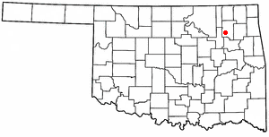
Location of Maramec, Oklahoma
Coordinates: 36°14′31″N96°40′50″W / 36.24194°N 96.68056°W / 36.24194; -96.68056
Country United States
State Oklahoma
County Pawnee
Area
[1]
  Total0.24 sq mi (0.63 km2)
  Land0.24 sq mi (0.63 km2)
  Water0.00 sq mi (0.00 km2)
Elevation
[2]
961 ft (293 m)
Population
 (2020)
  Total66
  Density271.60/sq mi (104.69/km2)
Time zone UTC-6 (Central (CST))
  Summer (DST) UTC-5 (CDT)
ZIP code
74045
Area code(s) 539/918
FIPS code 40-46400 [3]
GNIS feature ID2412950 [2]

Maramec is a town in Pawnee County, Oklahoma, United States. The population was 91 at the 2010 census, a decline of 12.5 percent from the figure 104 recorded in 2000. [4]

Contents

Geography

According to the United States Census Bureau, the town has a total area of 0.2 square miles (0.52 km2), all land.

Demographics

Historical population
CensusPop.Note
1910 224
1920 28728.1%
1930 37631.0%
1940 271−27.9%
1950 184−32.1%
1960 169−8.2%
1970 128−24.3%
1980 101−21.1%
1990 1108.9%
2000 104−5.5%
2010 91−12.5%
2020 66−27.5%
U.S. Decennial Census [5]

As of the census [3] of 2000, there were 104 people, 46 households, and 28 families residing in the town. The population density was 427.8 inhabitants per square mile (165.2/km2). There were 64 housing units at an average density of 263.3 per square mile (101.7/km2). The racial makeup of the town was 96.15% White, 2.88% Native American and 0.96% Asian. Hispanic or Latino of any race were 4.81% of the population.

There were 46 households, out of which 26.1% had children under the age of 18 living with them, 52.2% were married couples living together, 8.7% had a female householder with no husband present, and 37.0% were non-families. 32.6% of all households were made up of individuals, and 19.6% had someone living alone who was 65 years of age or older. The average household size was 2.26 and the average family size was 2.86.

In the town, the population was spread out, with 22.1% under the age of 18, 8.7% from 18 to 24, 28.8% from 25 to 44, 23.1% from 45 to 64, and 17.3% who were 65 years of age or older. The median age was 40 years. For every 100 females, there were 100.0 males. For every 100 females age 18 and over, there were 92.9 males.

The median income for a household in the town was $25,357, and the median income for a family was $24,750. Males had a median income of $19,167 versus $12,083 for females. The per capita income for the town was $12,578. There were no families and 1.8% of the population living below the poverty line, including no under eighteens and none of those over 64.

Historic Site

The First State Bank of Maramec is located at the junction of 2nd Ave. and Hickory St.

Related Research Articles

<span class="mw-page-title-main">Crystal, Maine</span> Town in the state of Maine, United States

Crystal is a town in Aroostook County, Maine, United States. The population was 248 at the 2020 census.
<span class="mw-page-title-main">Masardis, Maine</span> Town in Maine, United States

Masardis is a town in Aroostook County, Maine, United States. The population was 204 at the 2020 census.
<span class="mw-page-title-main">Etowah, Oklahoma</span> Town in Oklahoma, United States

Etowah is a town in Cleveland County, Oklahoma, United States. The population was 159 at the 2020 census, a 72.8% increase from 2010.

<span class="mw-page-title-main">Bradley, Oklahoma</span> Town in Oklahoma, United States

Bradley is a town in Grady County, Oklahoma, United States. The population was 78 at the 2020 United States census.

<span class="mw-page-title-main">Norge, Oklahoma</span> Town in Oklahoma, United States

Norge is a town in Grady County, Oklahoma, United States. The population was 129 at the 2020 census, a 11% decrease from 2010.
<span class="mw-page-title-main">Jefferson, Oklahoma</span> Town in Oklahoma, United States

Jefferson is a town in Grant County, Oklahoma, United States. The population was 12 at the 2010 census, a 67.6 percent decline from the figure of 37 in 2000.

<span class="mw-page-title-main">East Duke, Oklahoma</span> Town in Oklahoma, United States

East Duke, now known as Duke, is a town in Jackson County, Oklahoma, United States. The population was 394 as of the 2020 United States census. It is located about 14 miles west of the county seat of Altus, and is located at the intersection of US Route 62 and Oklahoma State Highway 34.

<span class="mw-page-title-main">Davenport, Oklahoma</span> Town in Oklahoma, United States

Davenport is a town in Lincoln County, Oklahoma, United States. The population was 814 at the 2010 census.

<span class="mw-page-title-main">Kendrick, Oklahoma</span> Town in Oklahoma, United States

Kendrick is a town in Lincoln County, Oklahoma, United States. The population was 139 at the 2010 census.

<span class="mw-page-title-main">Warwick, Oklahoma</span> Town in Oklahoma, United States

Warwick is a town in Lincoln County, Oklahoma, United States. The population was 184 at the 2020 census, up from 148 in 2010.

<span class="mw-page-title-main">Cimarron City, Oklahoma</span> Town in Oklahoma, United States

Cimarron City is a town in Logan County, Oklahoma, United States. The population was 150 at the 2010 census, a 39.4 percent gain over the figure of 110 in 2000. It is part of the Oklahoma City Metropolitan Statistical Area. Cimarron City is a combination bedroom and retirement community.

<span class="mw-page-title-main">Ringwood, Oklahoma</span> Town in Oklahoma, United States

Ringwood is a town in Major County, Oklahoma, United States. The population was 401 at the time of the 2020 Census. The town was given its name because it was ringed by woods from northwest to southeast; however, the town is no longer accurate to its name.

<span class="mw-page-title-main">Byars, Oklahoma</span> Town in Oklahoma, United States

Byars is a town in McClain County, Oklahoma, United States. The population was 184 at the 2020 census, down from 255 at the 2010 census.

<span class="mw-page-title-main">Hanna, Oklahoma</span> Town in Oklahoma, United States

Hanna is a town in southwestern McIntosh County, Oklahoma, United States. Its population was 102 at the time of the 2020 Census. It was named for Hanna Bullett, the daughter of a prominent early resident.

<span class="mw-page-title-main">Stidham, Oklahoma</span> Town in Oklahoma, United States

Stidham is a town in McIntosh County, Oklahoma, United States. The population was 16 at the 2010 census, a decline of 21.7 percent from 23 in 2000.
<span class="mw-page-title-main">Wainwright, Oklahoma</span> Town in Oklahoma, United States

Wainwright is a town in Muskogee County, Oklahoma, United States. The town was named for a local merchant, William Henry Wainwright. The population was 165 at the 2010 census, a decline of 16.2 percent from the figure of 197 recorded in 2000.

<span class="mw-page-title-main">Tribbey, Oklahoma</span> Town in Oklahoma, United States

Tribbey is a town in Pottawatomie County, Oklahoma, United States.The community was named for Alpheus M. Tribbey, landowner. The population was 337 by the 2020 United States census.

<span class="mw-page-title-main">Foyil, Oklahoma</span> Town in Oklahoma, United States

Foyil is a town in Rogers County, Oklahoma, United States. It was named for Alfred Foyil, a local landowner and the first postmaster of the town. The population was 344 at the 2010 census, a 47.0 percent increase over the figure of 234 recorded in 2000.
<span class="mw-page-title-main">Valley Park, Oklahoma</span> Town in Oklahoma, United States

Valley Park is a town in Rogers County, Oklahoma, United States. The population was 77 at the 2010 census, up 221 percent from the figure of 24 recorded in 2000.

<span class="mw-page-title-main">Long Lake, South Dakota</span> Town in South Dakota, United States

Long Lake is a town in McPherson County, South Dakota, United States. The population was 27 at the 2020 census.

References

  1. "ArcGIS REST Services Directory". United States Census Bureau. Retrieved September 20, 2022.
  2. 1 2 U.S. Geological Survey Geographic Names Information System: Maramec, Oklahoma
  3. 1 2 "U.S. Census website". United States Census Bureau . Retrieved January 31, 2008.
  4. CensusViewer: Population of the City of Maramec, Oklahoma. Retrieved March 21, 2012.
  5. "Census of Population and Housing". Census.gov. Retrieved June 4, 2015.