
Kilpeck is a village and civil parish in the county of Herefordshire, England. It is about nine miles (14 km) southwest of Hereford, just south of the A465 road and Welsh Marches Line to Abergavenny, and about five miles (8 km) from the border with Wales. On 1 April 2019 the parishes of Kenderchurch, St Devereux, Treville and Wormbridge were merged with Kilpeck.

Welsh Newton is a small village and civil parish in the county of Herefordshire, England. It is located close to the border with Wales to which the parish extends towards Monmouthshire. It should not be confused with Newton, a township-chapelry in Clodock Parish and near Longtown, or with Newton Leominister. Its postal address is in Wales, with Monmouth as its post town.
Weston Beggard is a small civil parish and hamlet in Herefordshire, England. It is located between the villages of Shucknall and Bartestree and lies approximately 6 km east of Hereford. It is on the north bank of the River Frome. The population of this parish at the 2011 Census was 214.

Moreton on Lugg is a village and civil parish in Herefordshire, England. The city and county town of Hereford is approximately 3 miles (5 km) to the south; the market town of Leominster 8 miles (13 km) to the north.

Yazor is a small village and civil parish in Herefordshire, England. The village is on the A480 road, approximately 8 miles (13 km) north-west of the city of Hereford, and about 1 mile (2 km) east of Offa's Dyke. Within the parish is the rural estate, former Price family country seat, and Second World War camp of Foxley, and the hamlet of Yarsop about 1 mile (2 km) to the north of the village. The population of the parish at the 2011 Census was 122.

Little Hereford is a small village and civil parish in Herefordshire, England. The civil parish includes the hamlet of Middleton. The population of the civil parish at the 2011 census was 394.

Almeley is a village and civil parish in Herefordshire, England. The civil parish includes the hamlets of Almeley Wooton, Woonton and Upcott. The 2011 Census recorded the parish's population as 601.

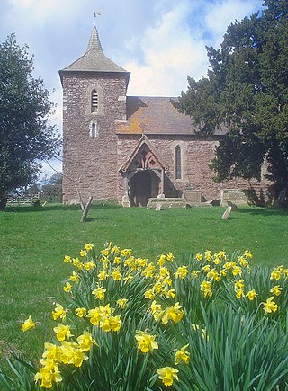
Whitney-on-Wye is a village and civil parish in Herefordshire, England, and approximately 1 mile (1.6 km) east from the border with Wales. The village is on the A438 road, on the River Wye, and 16 mi (25 km) west from Hereford. Parish population in 2011 was 117.

Dinedor is a hill, village and civil parish in Herefordshire, England. Dinedor is situated 5 km (3.1 mi) south east of Hereford. The hilltop is the site of Dinedor Camp, an Iron Age fort.

The Diocese of Hereford is a Church of England diocese based in Hereford, covering Herefordshire, southern Shropshire and a few parishes within Worcestershire in England, and a few parishes within Powys and Monmouthshire in Wales. The cathedral is Hereford Cathedral and the bishop is the Bishop of Hereford. The diocese is one of the oldest in England and is part of the Province of Canterbury.

Hereford and South Herefordshire is a constituency of the House of Commons of the UK Parliament. It comprises the city of Hereford and most of south Herefordshire and is currently represented by Jesse Norman of the Conservative Party.

Staunton on Wye is a relatively unpopulated civil parish in West Herefordshire, which is perhaps one of the most uninhabited locations of England. The parish of Staunton, which includes Moorhampton and Bredwardine, is a key player in trading in Herefordshire. The population of this parish taken at the 2011 census was 213. Recently, the village has become a growth area for various forms of development, unfortunately several developments have actively sort to undermine local planning rules and neighbourhood development frameworks, which has tarnished the reputation of the village to some extent. The most significant development in Staunton-on-wye in recent years is OakChurch, the local farm shop-cum-superstore. Despite its humble beginnings as a roadside shack selling strawberries and other soft fruit it has grown into a business selling everything from garden supplies to home decor. The sale of soft fruit still makes up a large portion of the business. This can be seen in the many hectares of local farmland that have been converted to polytunnels, resulting in Staunton's unglamorous nickname of Staunton-on-plastic!
Captain Richard Saher de Quincey was a noted British cattle breeder.
Grendon Bishop is a civil parish in the county of Herefordshire, England.

Pencombe with Grendon Warren is a civil parish in the county of Herefordshire, England. The parish was created in 1895 from the parishes of Pencombe and Grendon Warren, its only nucleated settlement being the village of Pencombe.

Humber is a hamlet and civil parish in the county of Herefordshire, England, and is 10 miles (16 km) north from the city and county town of Hereford. The closest large town is Leominster 3 miles (5 km) to the north-west.

King's Pyon is a village and civil parish in the county of Herefordshire, England, and is approximately 8 miles (13 km) north-west from the city and county town of Hereford. The closest large town is the market town of Leominster, 6 miles (10 km) to the north-west. The parish includes the Grade I listed church of St Mary the Virgin.

Felton is a small village and civil parish in the county of Herefordshire, England, and is 7 miles (11 km) north-east from the city and county town of Hereford. The closest town is the market town of Bromyard, 6 miles (10 km) to the north-east.

Staunton on Arrow is a village and civil parish in the county of Herefordshire, England. The village is 17 miles (27 km) north-west of Hereford and 8 miles (13 km) to the west of Leominster. Within the parish is the site of the Iron Age hill fort of Wapley Hill.

Sutton is a civil parish in Herefordshire, England, about 3 miles (5 km) north-east from the county town and city of Hereford. The major settlement is the village of Sutton St Nicholas which is conjoined with Sutton St Michael, formerly the village of a separate parish. The parish is sometimes referred to as Sutton St Nicholas. Within the parish is Sutton Walls, the supposed site of the palace of the kings of Mercia.


