Mining
In 2011, the Western Desert Resources Corporation, together with its partner Sherwin Iron, announced plans that it was planning to run a pipeline from its Roper Bar mining site to carry slurry to the island for treatment there before being offloaded into barges that would ferry the material to ships in deeper water for export to East Asian steel mills. The following year, in 2012 Maria Island was included in the Limmen National Park established that year, though the agreement excised considerable portions of land for mining exploration.
In 2014, the two companies collapsed in the wake of a slump in the iron ore market. Sometime afterwards the Dubai company Al-Rawda Resources expressed interest in resurrecting the earlier project, by planning to establish a coastal facility on the area's wetlands where barges could load ore for shipment to container vessels 6 lying 6 kilometers north of Maria Island. The Marra community expressed concerns that the infrastructure, if established, would contaminate what is a pristine reserve.
The protected areas of the Northern Territory consists of protected areas managed by the governments of the Northern Territory and Australia and private organisations with a reported total area of 335,527 square kilometres (129,548 sq mi) being 24.8% of the total area of the Northern Territory of Australia.
Litchfield National Park, covering approximately 1500 km2, is near the township of Batchelor, 100 km south-west of Darwin, in the Northern Territory of Australia. Each year the park attracts over 260,000 visitors.

The Top End of Australia's Northern Territory is a geographical region encompassing the northernmost section of the Northern Territory, which aside from the Cape York Peninsula is the northernmost part of the Australian continent. It covers a rather vaguely defined area of about 245,000 km² behind the northern coast from the Northern Territory capital of Darwin across to Arnhem Land with the Indian Ocean on the west, the Arafura Sea to the north, and the Gulf of Carpentaria to the east, and with the almost waterless semi-arid interior of Australia to the south, beyond the huge Kakadu National Park.

The Aboriginal Land Rights Act 1976 (ALRA) is Australian federal government legislation that provides the basis upon which Aboriginal Australian people in the Northern Territory can claim rights to land based on traditional occupation. It was the first law by any Australian government that legally recognised the Aboriginal system of land ownership, and legislated the concept of inalienable freehold title, as such was a fundamental piece of social reform. Its long title is An Act providing for the granting of Traditional Aboriginal Land in the Northern Territory for the benefit of Aboriginals, and for other purposes.

Pine Creek is a small town in the Katherine region of the Northern Territory, Australia. As at the 2021 Census there were 319 residents of Pine Creek, which is the fourth largest town between Darwin and Alice Springs.

The Victoria River is a river in the bioregion of Victoria Bonaparte in the Northern Territory of Australia. It flows for 560 kilometres (350 mi) from its source south of the Judbarra / Gregory National Park to the Joseph Bonaparte Gulf in the Timor Sea.

The McArthur River mine is a zinc-lead mine, situated about 70 kilometres southwest of Borroloola, near the Gulf of Carpentaria in the northeastern Northern Territory, Australia. It is operated by McArthur River Mining (MRM), a subsidiary of the Swiss mining company Glencore. Although discovered in the 1950s, when it was originally called the HYC or "Here's Your Chance" deposit, it only opened as a mine in 1995. Initially an underground mining operation, the mine has been converted to open-cut.

Numby Numby, also known as Nimby Nimby or Ngambingambi, is a sinkhole in the Northern Territory of Australia located in the locality of McArthur about 25 to 30 kilometres west-northwest of Borroloola.
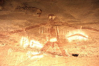
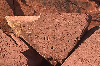
An Australian Aboriginal sacred site is a place deemed significant and meaningful by Aboriginal Australians based on their beliefs. It may include any feature in the landscape, and in coastal areas, these may lie underwater. The site's status is derived from an association with some aspect of social and cultural tradition, which is related to ancestral beings, collectively known as Dreamtime, who created both physical and social aspects of the world. The site may have its access restricted based on gender, clan or other Aboriginal grouping, or other factors.
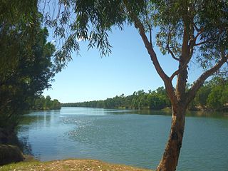
The McArthur River is a river in the Northern Territory of Australia which flows into the Gulf of Carpentaria at Port McArthur, opposite the Sir Edward Pellew Group of Islands. The river was named by Ludwig Leichhardt while he explored the area in 1845. He named the River after James MacArthur and the MacArthur family of Camden, who were enthusiastic supporters of his expedition. The McArthur River has significance for the local Aboriginal communities, who use it for fishing and other traditional activities.
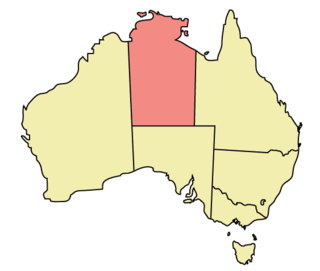
The Northern Territory (NT) occupies the north central part of the continent of Australia. The Northern Territory borders are to the west with Western Australia, the Western Australia border being near the 129° east longitude. The NT to the south with the South Australian border being the 26th parallel south latitude. To the east the NT with the Queensland border along the 138° east longitude.
Hancock Prospecting Pty Ltd is a leading Australian owned mining and agricultural business run by Executive Chairman Gina Rinehart and CEO Garry Korte. At stages of its trading, the company has been known as Hancock Prospecting Ltd, Hancock Resources Ltd, Hanwright Pty Ltd, Hancock & Wright Ltd, and Hancock Prospecting Pty Ltd.

The Gulf Country or North West Queensland is the region of woodland and savanna grassland surrounding the Gulf of Carpentaria in north western Queensland and eastern Northern Territory on the north coast of Australia. The region is also called the Gulf Savannah. The Gulf Country is crossed by the Savannah Way highway.
Pungalina-Seven Emu Sanctuary is a 3060 km2 private protected area in the Northern Territory of Australia. It is managed by the Australian Wildlife Conservancy (AWC) which purchased Pungalina Station in 2009, with some assistance from the Wildlife Australia Fund. It adjoins the Gulf of Carpentaria near the border with Queensland, lying in the Gulf Coastal bioregion. The reserve is bordered by Calvert Hills and Wollogorang Stations to the south and east. The nearest town is Borroloola, 150 km to the west.
Blue Mud Bay is a large, shallow, partly enclosed bay on the eastern coast of Arnhem Land, in the Northern Territory of Australia, facing Groote Eylandt on the western side of the Gulf of Carpentaria. It lies 580 km (360 mi) east-south-east of Darwin in the Arnhem Coast bioregion. Its name was given to a landmark court ruling affirming that the Aboriginal traditional owners of much of the Northern Territory's coastline have exclusive rights over commercial and recreational fishing in tidal waters overlying their land.

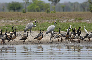
Limmen Bight is a bight, or large, open bay, located in the Northern Territory of Australia at the western end of the Gulf of Carpentaria about 360 kilometres (220 mi) east of the town of Katherine. It is part of the traditional lands and waters of the Marra people. It was named in April 1644 by Abel Tasman for one of his ships on his voyage of exploration along the northern Australian coast. It contains the second largest area of tidal flats in the Northern Territory.
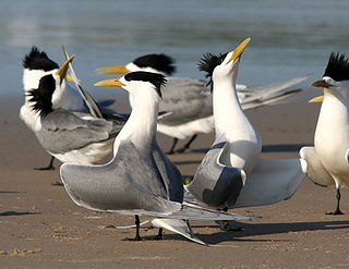
The Sandy Island and Low Rock Important Bird Area comprises two small islands with a collective area of 9 ha lying at the western end of the Gulf of Carpentaria in the Northern Territory of Australia. They lie south-west of Groote Eylandt off the coast of Arnhem Land, with the nearest settlement there the Numbulwar community. They are important as breeding sites for terns.
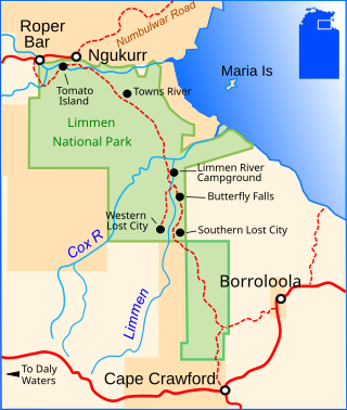
Limmen National Park, announced in 2012, is the third largest national park in the Northern Territory, after Judbarra / Gregory National Park, with an area of approximately 9,369 square kilometres (3,617 sq mi). Located about 600 km south-east of Darwin on the Gulf of Carpentaria, the park incorporates wetlands, sandstone structures and numerous rivers, including the Limmen Bight River from which the park takes its name.
The Garrwa people, also spelt Karawa and Garawa, are an Aboriginal Australian people living in the Northern Territory, whose traditional lands extended from east of the McArthur River at Borroloola to Doomadgee and the Nicholson River in Queensland.
The Marra, formerly sometimes referred to as Mara, are an Aboriginal Australian people of the Northern Territory.