Marine Park (neighborhood), Brooklyn

Last updated
Marine Park
GerristenAvenue.jpg
Gerritsen Avenue, a major traffic corridor in the neighborhood
Marine Park (neighborhood), Brooklyn
Location in New York City
Coordinates: 40°35′53″N73°55′12″W / 40.598°N 73.920°W / 40.598; -73.920
Country Flag of the United States.svg  United States
State Flag of New York.svg  New York
City Flag of New York City.svg  New York City
Borough Brooklyn
Community District Brooklyn 18
Population
 (2010) [1]
  Total45,231
 Neighborhood tabulation area; includes Mill Basin, Bergen Beach, Marine Park, and Flatlands
Ethnicity
[2]
  White73.8%
  Black10.9
  Hispanic7.9
  Asian5.6
  Other1.8
ZIP Code
11229, 11234
Area codes 718, 347, 929, and 917

Marine Park is a neighborhood in the New York City borough of Brooklyn. The neighborhood lies between Flatlands and Mill Basin to the east, and Gerritsen Beach, Midwood, and Sheepshead Bay to the south and west. It is mostly squared off in area by Gerritsen Avenue, Flatbush Avenue, Avenue U and Kings Highway. The neighborhood's eponymous park is the largest public park in Brooklyn. [3] Charles Downing Lay won a silver medal in town planning at the 1936 Olympics for the planning of Marine Park. [4]

Contents

Marine Park is largely inhabited by people of ethnic groups such as Italian Americans, Irish Americans, Greek Americans, and Jewish Americans. The area is part of Brooklyn Community Board 18. [5]

History

The neighborhood is situated around Gerritsen Creek, the westernmost inlet of Jamaica Bay; [6] the creek's path within the neighborhood was covered in 1920. [7] [8] During the last 5,000 years, strips of sand were deposited by ocean currents. These beach strips form a surf-barrier and allow salt marshes to thrive:

...Gerritsen Creek was a freshwater stream that once extended about twice as far inland as it does today. Around 1920 the creek north of Avenue U was converted into an underground storm drain. Yet it continues to supply the salt marsh with fresh water, which helps the marsh support a wide range of organisms... [9]

The area was a hunting and fishing ground for Native Americans from the nearby village of Keshawchqueren. Pits for cooking and preparing food dating from 800 to 1400 AD were uncovered in Marine Park, along with deer and turtle bones, oyster shells, and sturgeon scales. In the 17th century, the Dutch began to settle in the area, which had similarities to the marshland and coastal plains of the Netherlands. The land proved to be fairly good farmland and there was an abundance of clams, oysters, and game from the region as well.

...Fearing that the relatively pristine marshland around Gerritsen Creek would be destroyed, Frederick B. Pratt and Alfred T. White offered the city 150 acres (0.6 km2) in the area for use as a park in 1917. After a seven-year delay the City accepted the offer. The prospect of a new park inspired developers to erect new homes in the area and, in the year 1926, form the organization, Marine Park Civic Association, although park improvements were slow to follow. Fill deposited in the marshlands in the 1930s and now land purchases increased the park's area to 1,822 acres (7 km2) by 1937. That year the Board of Aldermen named the site Brooklyn Marine Park... [9]

One of the oldest houses in the neighborhood is the Hendrick I. Lott House, built in 1720. The house is listed on the National Register of Historic Places and is a New York City designated landmark. [10] [11] In the 18th century, George Washington made a stop for several days on the land nearby. There was a gristmill on the water at the time.

As early as 1910, developers began dredging ports within Jamaica Bay in an effort to develop a seaport district there. [12] Although the city allowed several piers to be constructed in 1918, only one was built on the former Barren Island. The pier, which was built in order to receive landfill for the other proposed piers, stretched 1 mile (1.6 km) northeast and was 700 feet (210 m) wide. [13] In 1931, the city took possession of 58 acres (23 ha) on the western side of Barren Island. That plot was combined with a 110-acre (45 ha) tract owned by Kings County to create the park named Marine Park. [14] :51 Urban planner Robert Moses expanded Marine Park in 1935, and the city acquired 1,822 acres (737 ha) of land. This comprised the entire island west of Flatbush Avenue. [14] :53 Barren Island's residents were mostly evicted by 1939, and part of the island became part of Marine Park, but much of the rest of the island became Floyd Bennett Field. [15]

In 1935, the mill burned down to the water level due to vandals, leaving only wood pilings across the water, which can be clearly seen to this day during low tide. In the mid-20th century the area was abused by trash and abandoned cars. At one point it became a landfill and trash piled up to 60 feet (18 m) in certain areas. After a massive cleanup effort in the 1990s the area was restored to its former glory, with exception of a few rusty car parts riddling the area, and teens littering and causing arson to the dry tall Phragmites from time to time.

Demographics

Marine Park is located in zip code 11234, which also includes Mill Basin, Bergen Beach/Georgetown, and the southern portion of Flatlands. Based on data from the 2010 United States Census, the combined population of Georgetown, Marine Park, Bergen Beach, and Mill Basin was 45,231, an increase of 2,291 (5.3%) from the 42,940 counted in 2000. Covering an area of 1,662.88 acres (672.94 ha), the neighborhood had a population density of 27.2 inhabitants per acre (17,400/sq mi; 6,700/km2). [1]

By the end of the 20th century, the majority of Marine Park residents were white, as were most residents of adjacent neighborhoods such as Mill Basin and Bergen Beach. [16] By 2011, the number of black residents in Southeast Brooklyn had risen 241%, the steepest such increase of any area in the city. As of that year, the African American population in these neighborhoods represented 10.9% of the total population. [17] As of the 2010 Census, the racial makeup of Southeast Brooklyn was 73.8% (33,399) White, 10.9% (4,952) African American, 0.1% (47) Native American, 5.6% (2,521) Asian, 0.0% (7) Pacific Islander, 0.3% (144) from other races, and 1.3% (578) from two or more races. Hispanic or Latino of any race were 7.9% (3,583) of the population. [2] The 2020 census data from New York City Department of City Planning showed that the Marine Park/Mill Basin/Bergen Beach area has between 20,000 and 29,999 White residents and 5,000 to 9,999 Black residents, meanwhile the Hispanic and Asian populations each were less than 5000 residents. [18] [19]

Police and crime

Marine Park is patrolled by the New York City Police Department's 63rd Precinct. [20] The precinct also covers Bergen Beach, Mill Basin, and part of Flatlands. [21] The 63rd Precinct ranked 31st safest out of 69 patrol areas for per-capita crime in 2010. [22]

The 63rd Precinct has a lower crime rate than in the 1990s, with crimes across all categories having decreased by 82.7% between 1990 and 2022. The precinct reported 1 murder, 10 rapes, 114 robberies, 170 felony assaults, 119 burglaries, 537 grand larcenies, and 135 grand larcenies auto in 2022. [23]

Transportation

Marine Park is served by the B2 , B3 , B9 , B31 , B41 , B44 , B44 SBS , B46 , B46 SBS , B47 , B100 , BM4 and Q35 bus routes, operated by MTA Regional Bus Operations. [24] There are no New York City Subway stations in the neighborhood; the closest is the Kings Highway station in Midwood. The closest highway available in the neighborhood is the Belt Parkway on the Flatbush Avenue exit.

Park

The park's Salt Marsh Nature Center Prirodnyi Tsentr Salt Marsh.jpg
The park's Salt Marsh Nature Center

The neighborhood also contains a public park of the same name. The park's 530 acres (2.1 km2) of grassland and salt marsh surround the westernmost inlet of Jamaica Bay. [3] Most of the park's land was donated to New York City in the 1910s and 1920s, and consists of the area between the current day Fillmore Avenue and Gerritsen Avenue and East 38th Street. Originally almost 2,000 acres (810 ha), over half of which has been donated to the National Park Service as part of the Gateway National Recreation Area, the park is mainly a fertile salt marsh that is supplied with freshwater from Gerritsen Creek. Marine Park consists of recreational park areas and the Salt Marsh Nature Center. [12] There is also a playground, several sports fields, and 0.83 mile-long running path, all of which were built on the ancient Keshawchqueren burial ground. [25]

Notable people

See also

Related Research Articles

<span class="mw-page-title-main">Flatlands, Brooklyn</span> Neighborhood of Brooklyn in New York City

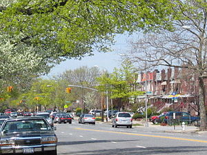
Flatlands is a neighborhood in the southeast part of the borough of Brooklyn in New York City. The current neighborhood borders are roughly defined by the Bay Ridge Branch to the north, Avenue U to the south, Ralph Avenue to the east, and Flatbush Avenue to the southwest.

<span class="mw-page-title-main">Canarsie, Brooklyn</span> Neighborhood of Brooklyn in New York City

Canarsie is a mostly residential neighborhood in the southeastern portion of Brooklyn, New York City. Canarsie is bordered on the east by Fresh Creek Basin and East 108th Street; on the north by Linden Boulevard; on the west by Ralph Avenue; on the southwest by Paerdegat Basin; and on the south by Jamaica Bay. It is adjacent to the neighborhoods of East Flatbush to the west, Flatlands and Bergen Beach to the southwest, Starrett City to the east, East New York to the northeast, and Brownsville to the north.

<span class="mw-page-title-main">Howard Beach, Queens</span> Neighborhood of Queens in New York City

Howard Beach is a neighborhood in the southwestern portion of the New York City borough of Queens. It is bordered to the north by the Belt Parkway and Conduit Avenue in Ozone Park, to the south by Jamaica Bay in Broad Channel, to the east by 102nd–104th Streets in South Ozone Park, and to the west by 75th Street in East New York, Brooklyn. The area consists mostly of low-rise single-family houses.

<span class="mw-page-title-main">Gerritsen Beach, Brooklyn</span> Neighborhood in Brooklyn, New York, U.S.

Gerritsen Beach is a neighborhood in the New York City borough of Brooklyn, located between Sheepshead Bay to the west and Marine Park to the east. The area is served by Brooklyn Community Board 15. The population of the neighborhood is 4,797 as of the 2020 U.S. census.

<span class="mw-page-title-main">Sheepshead Bay, Brooklyn</span> Neighborhood of Brooklyn in New York City

Sheepshead Bay is a neighborhood in southern Brooklyn, New York City. It is bounded by Ocean Parkway to the west; Avenue T and Kings Highway to the north; Nostrand Avenue and Gerritsen Avenue to the east; and the Atlantic Ocean to the south. Sheepshead Bay is abutted by the neighborhoods of Brighton Beach and Homecrest to the west; Midwood to the north; and Gerritsen Beach to the east.

<span class="mw-page-title-main">South Brooklyn</span>

South Brooklyn is a historic term for a section of the former City of Brooklyn – now the New York City borough of Brooklyn – encompassing what are now the Boerum Hill, Carroll Gardens, Cobble Hill, Gowanus, Park Slope, Windsor Terrace, Sunset Park and Red Hook neighborhoods. It was named for its location along the waterfront that was the southern border of the original Village of Brooklyn, and has remained widely used as a colloquialism despite it no longer being the southernmost point of the borough. It should not be confused with the geographic southern region of the modern borough of Brooklyn, which includes the neighborhoods of Gravesend, Seagate, Coney Island, Brighton Beach, Manhattan Beach, Sheepshead Bay, Gerritsen Beach, Marine Park, Mill Basin, and Bergen Beach.

<span class="mw-page-title-main">Mill Basin, Brooklyn</span> Neighborhood of Brooklyn in New York City

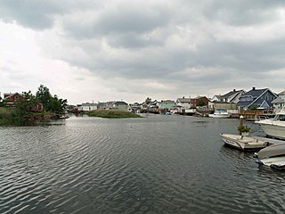
Mill Basin is a residential neighborhood in southeastern Brooklyn, New York City. It is on a peninsula abutting Jamaica Bay and is bordered by Avenue U on the northwest and the Mill Basin/Mill Island Inlet on its remaining sides. Mill Basin is adjacent to the neighborhood of Bergen Beach to the northeast, Flatlands to the northwest, Marine Park to the southwest, and Floyd Bennett Field and the former Barren Island to the southeast. Mill Basin also contains a subsection called Old Mill Basin, north of Avenue U.

<span class="mw-page-title-main">Marine Park (Brooklyn park)</span> Public park in Brooklyn, New York

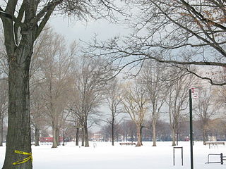
Marine Park is a public park located in the neighborhood of Marine Park in Brooklyn, New York. Its 798 acres (3.2 km2) surround the westernmost inlet of Jamaica Bay. Most of the land for Marine Park was donated to New York City to be turned into public park land by the Whitney family in 1920 and by Frederic B. Pratt and Alfred Tredway White, who jointly donated 150 acres (0.61 km2) in 1917. The land donated consists of the area between the current day Fillmore Avenue and Gerritsen Avenue and East 38th Street. Originally almost 2,000 acres (810 ha), over half of which has been donated to the National Park Service as part of the Gateway National Recreation Area, the park is mainly a fertile salt marsh which is supplied with freshwater from Gerritsen Creek.

Brooklyn Community Board 18 is a New York City community board that encompasses the Brooklyn neighborhoods of Canarsie, Bergen Beach, Mill Basin, Flatlands, Marine Park, Georgetown, and Mill Island. It is delimited by Nostrand Avenue on the west, the Long Island Rail Road on the north, Van Sinderen Avenue and Louisiana Avenue on the east, as well as by Shore Parkway on the south.

<span class="mw-page-title-main">Community boards of Brooklyn</span>

Community boards of Brooklyn are New York City community boards in the borough of Brooklyn, which are the appointed advisory groups of the community districts that advise on land use and zoning, participate in the city budget process, and address service delivery in their district.

New York's 8th congressional district for the U.S. House of Representatives is in the New York City borough of Brooklyn. It is currently represented by Representative Hakeem Jeffries, the House Minority Leader.

<span class="mw-page-title-main">Bergen Beach, Brooklyn</span> Neighborhood of Brooklyn in New York City

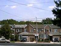
Bergen Beach is a residential neighborhood in the borough of Brooklyn, New York City. It is located on a peninsula abutting Jamaica Bay in the southeastern portion of the borough, and is bordered by Mill Basin and the neighborhood of the same name to the south and west; the neighborhood of Flatlands to the northwest; Paerdegat Basin and the neighborhood of Canarsie to the northeast; and Jamaica Bay and the Belt Parkway to the east. Bergen Beach contains a sub-neighborhood named Georgetown. The vast majority of residents are white, and the neighborhood generally has a suburban quality.

<span class="mw-page-title-main">Paerdegat Basin</span>

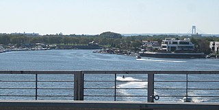
Paerdegat Basin is a channel that connects to Jamaica Bay between the neighborhoods of Bergen Beach and Canarsie in southeast Brooklyn, New York, United States. It connects to Jamaica Bay to the south, and the north end of the basin is adjacent to the intersection of Ralph Avenue and Flatlands Avenue. "Paerdegat" derives from the old Dutch paardengat, meaning "horse gate".

<span class="mw-page-title-main">Spring Creek, Brooklyn</span> Neighborhood of Brooklyn in New York City

Spring Creek, previously called Spring Creek Basin, is a neighborhood within the East New York section of Brooklyn in New York City. It roughly comprises the southern portions of East New York between Flatlands Avenue to the north, and Jamaica Bay and the Gateway National Recreation Area to the south, with the Brooklyn neighborhood of Canarsie to the west and the Queens neighborhood of Howard Beach to the east. It is named after Spring Creek, one of several creeks that formerly ran through the area and drained into Jamaica Bay.

Flatlands Avenue is a major street in the New York City borough of Brooklyn. It runs approximately 5 miles (8.0 km) east-west, from Avenue N and East 35th Street in Flatlands in the west to Forbell Street, east of Fountain Avenue in East New York, near the Brooklyn-Queens border. The right-of-way continues in Lindenwood and Howard Beach, Queens as 156th Avenue, separated by the remnants of Spring Creek. The portion of Flatlands Avenue east of Louisiana Avenue in East New York was previously mapped as Fairfield Avenue.

<span class="mw-page-title-main">Mau Mau Island</span>

Mau Mau Island, also called White Island, is a small uninhabited island in the New York City borough of Brooklyn, located between Gerritsen Creek and Mill Creek in the Marine Park recreation area. Historically, the area around Mau Mau Island was a salt marsh with shifting topography. The island came into existence permanently sometime after 1917, and most likely formed in 1934 as dumping led to the current shoreline.

<span class="mw-page-title-main">Gerritsen Creek</span> Creek in Brooklyn, New York

Gerritsen Creek is a short watercourse in Brooklyn, New York City, that empties into Jamaica Bay. The creek has been described as one of the "fingers" that formed the original shoreline of Jamaica Bay. The creek lies just beyond the maximum extent of the Wisconsin Glacier.

<span class="mw-page-title-main">Spring Creek Park</span> Public park in New York City

Spring Creek Park is a public park along the Jamaica Bay shoreline between the neighborhoods of Howard Beach, Queens, and Spring Creek, Brooklyn, in New York City. Created on landfilled former marshland, the park is mostly an undeveloped nature preserve, with only small portions accessible to the public for recreation.

References

  1. 1 2 Table PL-P5 NTA: Total Population and Persons Per Acre - New York City Neighborhood Tabulation Areas*, 2010, Population Division - New York City Department of City Planning, February 2012. Accessed June 16, 2016.
  2. 1 2 Table PL-P3A NTA: Total Population by Mutually Exclusive Race and Hispanic Origin - New York City Neighborhood Tabulation Areas*, 2010, Population Division - New York City Department of City Planning, March 29, 2011. Accessed June 14, 2016.
  3. 1 2 Marine Park, New York City Department of Parks and Recreation. Accessed September 24, 2016. "As Brooklyn's largest park, Marine Park has plenty of room to serve a lot of needs. Environmentally, it consists of 530 acres (210 ha) of grassland and precious salt marsh, protected as a Forever Wild preserve."
  4. "And the Medal Goes to..." Brooklyn Public Library. Retrieved August 12, 2016.
  5. "Brooklyn Community Boards". City of New York. Archived from the original on July 19, 2017. Retrieved March 17, 2014.
  6. "Officials Celebrate the Gerritsen Creek Ecosystem Restoration Project in Marine Park". United States Army Corps of Engineers. 2012-08-14.
  7. Josephine Axt (2003). "Ecosystem restoration promotes understanding" (PDF). US Army Corps of Engineers.
  8. "FACT SHEET-Gerritsen Creek–MARINE PARK, NY: Ecosystem Restoration Project". US Army Corps of Engineers.
  9. 1 2 Marine Park Civic Association. "The History of Marine Park". Archived from the original on November 18, 2013. Retrieved July 24, 2006.
  10. Larry E. Gobrecht (February 1981). "National Register of Historic Places Registration:Hendrick I. Lott House". New York State Office of Parks, Recreation and Historic Preservation . Retrieved 2011-02-20.See also: "Accompanying four photos".
  11. "Hendrick I. Lott House : NYC Parks". New York City Department of Parks & Recreation. June 26, 1939. Retrieved May 18, 2019.
  12. 1 2 "Marine Park Highlights". New York City Department of Parks & Recreation. June 17, 2003. Retrieved January 6, 2018.
  13. Black, Frederick R. (1981). "JAMAICA BAY: A HISTORY" (PDF). United States Department of the Interior, National Park Service: 77–79.{{cite journal}}: Cite journal requires |journal= (help)
  14. 1 2 Cody, Sarah K.; Auwaerter, John; Curry, George W. (2009). "Cultural Landscape Report for Floyd Bennett Field" (PDF). nps.gov . State University of New York, College of Environmental Science and Forestry.
  15. "BARREN ISLAND IS FADING; Marine Park Squeezing Out Community On the Sand Dunes in Jamaica Bay" (PDF). The New York Times. February 19, 1939. Retrieved January 7, 2018.
  16. Friedman, Andrew (2001-06-03). "NEIGHBORHOOD REPORT: SOUTHEAST BROOKLYN; Drops of Diversity in a Quiet Area". The New York Times. Retrieved 2018-01-15.
  17. Musumeci, Natalie; Durkin, Erin (September 22, 2011). "Black pop. growing in south Bk". NY Daily News. Retrieved 2018-01-15.
  18. "Key Population & Housing Characteristics; 2020 Census Results for New York City" (PDF). New York City Department of City Planning. August 2021. pp. 21, 25, 29, 33. Retrieved November 7, 2021.
  19. "Map: Race and ethnicity across the US". CNN. August 14, 2021. Retrieved November 7, 2021.
  20. Teicher, Jordan G. (2015-07-08). "City Living: Bergen Beach satisfies your craving for real suburban living". am New York. Retrieved 2018-01-15.
  21. "NYPD – 63rd Precinct". www.nyc.gov. Retrieved October 3, 2016.
  22. "Flatlands – DNAinfo.com Crime and Safety Report". www.dnainfo.com. Archived from the original on April 15, 2017. Retrieved October 6, 2016.
  23. "63rd Precinct CompStat Report" (PDF). www.nyc.gov. New York City Police Department . Retrieved July 22, 2018.
  24. "Brooklyn Bus Map" (PDF). Metropolitan Transportation Authority. October 2020. Retrieved December 1, 2020.
  25. Wall, Diana diZerega (2004). Touring Gotham's Archaeological Past: 8 Self-Guided Walking Tours through New York City. Yale University. pp. 173–175. ISBN   0300103883.
  26. Rimer, Sara. "Chess At New York Open: 'It's Like A War'", The New York Times , April 18, 1987. Accessed February 11, 2018. "In hopes of one day becoming a world champion, Mr. Benjamin, a Yale graduate from the Marine Park section of Brooklyn, said he will be moving to Barcelona next month to pursue chess under the tutelage of John Fedorowicz, a grandmaster from New York."
  27. "The scapegoating of Harvey Pitt", Institutional Investor , July 31, 2002. Accessed June 3, 2023. "Pitt was born on February 28, 1945, in Crown Heights, then a middle-class section of Brooklyn....When he was seven, his family moved east to the more serene Marine Park neighborhood, where young Harvey spent most of his time off from public school playing stickball and going to see Brooklyn Dodgers games at Ebbets Field -- until the team split for Los Angeles in 1957."
  28. Murphy, Doyle. "Bitcoin coming to Park Slope hotel? Not so fast, manager says", New York Daily News , June 17, 2014. February 11, 2018. "Shrem, who grew up in Marine Park, has become something of a rock star among the currency’s fervent followers. An early adopter, he began accepting bitcoin at his Manhattan bar EVR years ago and is a self-described millionaire at age 24."
  29. Weiss, Steven I. "Hirhurim Blogger Gil Student Hired by OU Press", The Jewish Channel, May 26, 2009. Accessed February 11, 2018. "Rabbi Student and his wife of 15 years, Miriam, live in the Marine Park section of Brooklyn with their four children."
  30. Newman, Andy. "Kind Words for Torre, From Marine Park to the Bronx", The New York Times , October 10, 2007. Accessed February 11, 2018. "Beside the ballfields at Marine Park in Brooklyn, where pudgy young Joe Torre grew up and where he smacked some of his first home runs, Bob Rosenstein, walking the track after a lunchtime run, spoke admiringly of Mr. Torre’s work for domestic violence victims and for young athletes."
  31. "A Writer's Road. Famed Writer Speaks To The Rockaway Times". rockawaytimes.com. Retrieved 2018-12-26.