
In meteorology, a cloud is an aerosol consisting of a visible mass of miniature liquid droplets, frozen crystals, or other particles suspended in the atmosphere of a planetary body or similar space. Water or various other chemicals may compose the droplets and crystals. On Earth, clouds are formed as a result of saturation of the air when it is cooled to its dew point, or when it gains sufficient moisture from an adjacent source to raise the dew point to the ambient temperature.
Cloud feedback is the coupling between cloudiness and surface air temperature where a surface air temperature change leads to a change in clouds, which could then amplify or diminish the initial temperature perturbation. Cloud feedbacks can affect the magnitude of internally generated climate variability or they can affect the magnitude of climate change resulting from external radiative forcings.

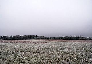
Fog is a visible aerosol consisting of tiny water droplets or ice crystals suspended in the air at or near the Earth's surface. Fog can be considered a type of low-lying cloud usually resembling stratus, and is heavily influenced by nearby bodies of water, topography, and wind conditions. In turn, fog affects many human activities, such as shipping, travel, and warfare.

Upwelling is an oceanographic phenomenon that involves wind-driven motion of dense, cooler, and usually nutrient-rich water from deep water towards the ocean surface. It replaces the warmer and usually nutrient-depleted surface water. The nutrient-rich upwelled water stimulates the growth and reproduction of primary producers such as phytoplankton. The biomass of phytoplankton and the presence of cool water in those regions allow upwelling zones to be identified by cool sea surface temperatures (SST) and high concentrations of chlorophyll-a.
Stratus clouds are low-level clouds characterized by horizontal layering with a uniform base, as opposed to convective or cumuliform clouds that are formed by rising thermals. More specifically, the term stratus is used to describe flat, hazy, featureless clouds at low altitudes varying in color from dark gray to nearly white. The word stratus comes from the Latin prefix strato-, meaning "layer". Stratus clouds may produce a light drizzle or a small amount of snow. These clouds are essentially above-ground fog formed either through the lifting of morning fog or through cold air moving at low altitudes over a region. Some call these clouds "high fog" for their fog-like form. While light rain may fall, this cloud does not indicate much meteorological precipitation.

In meteorology, precipitation is any product of the condensation of atmospheric water vapor that falls under gravitational pull from clouds. The main forms of precipitation include drizzle, rain, sleet, snow, ice pellets, graupel and hail. Precipitation occurs when a portion of the atmosphere becomes saturated with water vapor, so that the water condenses and "precipitates" or falls. Thus, fog and mist are not precipitation but colloids, because the water vapor does not condense sufficiently to precipitate. Two processes, possibly acting together, can lead to air becoming saturated: cooling the air or adding water vapor to the air. Precipitation forms as smaller droplets coalesce via collision with other rain drops or ice crystals within a cloud. Short, intense periods of rain in scattered locations are called showers.

Global dimming is the reduction in the amount of global direct irradiance at the Earth's surface that has been observed since systematic measurements began in the 1950s. The effect varies by location, but worldwide it has been estimated to be of the order of a 4–20% reduction. However, after discounting an anomaly caused by the eruption of Mount Pinatubo in 1991, a very slight reversal in the overall trend has been observed.

Cloud physics is the study of the physical processes that lead to the formation, growth and precipitation of atmospheric clouds. These aerosols are found in the troposphere, stratosphere, and mesosphere, which collectively make up the greatest part of the homosphere. Clouds consist of microscopic droplets of liquid water, tiny crystals of ice, or both. Cloud droplets initially form by the condensation of water vapor onto condensation nuclei when the supersaturation of air exceeds a critical value according to Köhler theory. Cloud condensation nuclei are necessary for cloud droplets formation because of the Kelvin effect, which describes the change in saturation vapor pressure due to a curved surface. At small radii, the amount of supersaturation needed for condensation to occur is so large, that it does not happen naturally. Raoult's law describes how the vapor pressure is dependent on the amount of solute in a solution. At high concentrations, when the cloud droplets are small, the supersaturation required is smaller than without the presence of a nucleus.

June Gloom is a California term for a weather pattern that results in cloudy, overcast skies with cool temperatures during the late spring and early summer. While it is most common in the month of June, it can occur in surrounding months, giving rise to other colloquialisms, such as "May Gray", "No-Sky July", and "Fogust". Low-altitude stratus clouds form over the cool water of the California Current, and spread overnight into the coastal regions of California.

Sea surface temperature (SST), or ocean surface temperature, is the ocean temperature close to the surface. The exact meaning of surface varies according to the measurement method used, but it is between 1 millimetre (0.04 in) and 20 metres (70 ft) below the sea surface. Air masses in the Earth's atmosphere are highly modified by sea surface temperatures within a short distance of the shore. Localized areas of heavy snow can form in bands downwind of warm water bodies within an otherwise cold air mass. Warm sea surface temperatures are known to be a cause of tropical cyclogenesis over the Earth's oceans. Tropical cyclones can also cause a cool wake, due to turbulent mixing of the upper 30 metres (100 ft) of the ocean. SST changes diurnally, like the air above it, but to a lesser degree. There is less SST variation on breezy days than on calm days. In addition, ocean currents such as the Atlantic Multidecadal Oscillation (AMO), can affect SST's on multi-decadal time scales, a major impact results from the global thermohaline circulation, which affects average SST significantly throughout most of the world's oceans.

Drizzle is a light liquid precipitation consisting of liquid water drops smaller than those of rain – generally smaller than 0.5 mm (0.02 in) in diameter. Drizzle is normally produced by low stratiform clouds and stratocumulus clouds. Precipitation rates from drizzle are on the order of a millimetre (0.04 in) per day or less at the ground. Owing to the small size of drizzle drops, under many circumstances drizzle largely evaporates before reaching the surface and so may be undetected by observers on the ground. The METAR code for drizzle is DZ and for freezing drizzle is FZDZ.

Fog is a common weather phenomenon in the San Francisco Bay Area as well as along the entire coastline of California extending south to the northwest coast of the Baja California Peninsula. The frequency of fog and low-lying stratus clouds is due to a combination of factors particular to the region that are especially prevalent in the summer. Another type of fog, tule fog, can occur during the winter. There are occasions when both types can occur simultaneously in the Bay Area. The prevalence of fog in the San Francisco Bay Area has decreased, and this trend is typically attributed to climate change.
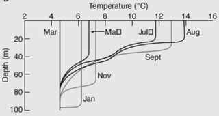
The oceanic or limnological mixed layer is a layer in which active turbulence has homogenized some range of depths. The surface mixed layer is a layer where this turbulence is generated by winds, surface heat fluxes, or processes such as evaporation or sea ice formation which result in an increase in salinity. The atmospheric mixed layer is a zone having nearly constant potential temperature and specific humidity with height. The depth of the atmospheric mixed layer is known as the mixing height. Turbulence typically plays a role in the formation of fluid mixed layers.

An actinoform or actiniform describes a collection of marine low clouds that takes a distinct shape. They are named after the Greek word for "ray" due to their radial structure. Actinoform clouds can spread out over 300 km (190 mi) across and thus cannot be easily seen with the naked eye. In addition, actinoform clouds can form "trains" that are up to six times the length of the original cloud field, yet they maintain their own distinct identity.

Ship tracks are clouds that form around the exhaust released by ships into the still ocean air. Water molecules collect around the tiny particles (aerosols) from exhaust to form a cloud seed. More and more water accumulates on the seed until a visible cloud is formed. In the case of ship tracks, the cloud seeds are stretched over a long narrow path where the wind has blown the ship's exhaust, so the resulting clouds resemble long strings over the ocean. Ship tracks are a type of homogenitus cloud.

A marine layer is an air mass that develops over the surface of a large body of water, such as an ocean or large lake, in the presence of a temperature inversion. The inversion itself is usually initiated by the cooling effect of the water on the surface layer of an otherwise warm air mass.
The climate of San Diego, California is classified as a Mediterranean climate. The basic climate features hot, sunny, and dry summers, and cooler, wetter winters. However, San Diego is much more arid than typical Mediterranean climates, and winters are still dry compared with most other zones with this type of climate.
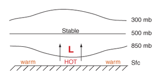
Thermal lows, or heat lows, are non-frontal low-pressure areas that occur over the continents in the subtropics during the warm season, as the result of intense heating when compared to their surrounding environments. Thermal lows occur near the Sonoran Desert, on the Mexican plateau, in California's Great Central Valley, in the Sahara, over north-west Argentina in South America, over the Kimberley region of north-west Australia, over the Iberian peninsula, and over the Tibetan plateau.
Marine cloud brightening also known as marine cloud seeding and marine cloud engineering is a proposed solar radiation management climate engineering technique that would make clouds brighter, reflecting a small fraction of incoming sunlight back into space in order to offset anthropogenic global warming. Along with stratospheric aerosol injection, it is one of the two solar radiation management methods that may most feasibly have a substantial climate impact. The intention is that increasing the Earth's albedo, in combination with greenhouse gas emissions reduction, carbon dioxide removal, and adaptation, would reduce climate change and its risks to people and the environment. If implemented, the cooling effect is expected to be felt rapidly and to be reversible on fairly short time scales. However, technical barriers remain to large-scale marine cloud brightening. There are also risks with such modification of complex climate systems.
The Surface Heat Budget of the Arctic Ocean (SHEBA) study was a National Science Foundation-funded research project designed to quantify the heat transfer processes that occur between the ocean and the atmosphere over the course of a year in the Arctic Ocean, where the sun is above the horizon from spring through summer and below the horizon the rest of the time. The study was designed to provide data for use in global climate models, which scientists use to study global climate change.
