Collegedale Municipal Airport is a city-owned, public-use airport located two nautical miles (4 km) southeast of the central business district of the Collegedale, a city in Hamilton County, Tennessee, United States.
Rockwood Municipal Airport is a public use airport in Morgan County and Cumberland County, Tennessee, United States. It is located three nautical miles (6 km) north of Rockwood, which owns the airport, and about 6 miles (9.7 km) west of the Harriman, both cities in Roane County. Situated on Walden Ridge near the southern end of the Cumberland Plateau, the airport is convenient to Interstate 40. It is included in the National Plan of Integrated Airport Systems for 2011–2015, which categorized it as a general aviation facility.

Zanesville Municipal Airport is a city-owned airport six miles east of downtown Zanesville, in Muskingum County, Ohio. The National Plan of Integrated Airport Systems for 2011–2015 called it a general aviation facility.
Palmer Municipal Airport is a public airport located 1 mi (1.6 km) southeast of the central business district of Palmer, a city in Matanuska-Susitna Borough, Alaska, United States. This airport is owned by the City of Palmer.
Plant City Airport is a public-use airport located two nautical miles (4 km) southwest of the central business district of Plant City in Hillsborough County, Florida, United States. The airport is publicly owned by the Hillsborough County Aviation Authority, which also operates Tampa International Airport. It was formerly known as Plant City Municipal Airport. It supports a 400-acre (1.6 km2) industrial park located about one mile (1.6 km) east of the airport.
Greeneville Municipal Airport is a public airport located two miles (3 km) north of the central business district of Greeneville, a town in Greene County, Tennessee, United States. It is owned by the Town of Greeneville.
Fernandina Beach Municipal Airport is a city-owned public-use airport located on Amelia Island three nautical miles (6 km) south of the central business district of Fernandina Beach, a city in Nassau County, Florida, United States. It is designated as a reliever airport for Jacksonville International Airport.
West Memphis Municipal Airport is a city-owned public-use airport located three miles (5 km) west of the central business district of West Memphis, in Crittenden County, Arkansas, United States. The airport is 10 nmi (19 km) southwest of General DeWitt Spain Airport in Memphis, Tennessee.
Shelbyville Municipal Airport is a city-owned public-use airport located four miles north of the central business district of Shelbyville, a city in Bedford County, Tennessee, United States.
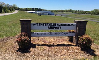
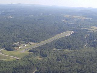
Centerville Municipal Airport is a city-owned public-use airport located three miles north of the central business district of Centerville, a city in Hickman County, Tennessee, United States.
Covington Municipal Airport is a city-owned public-use airport located three miles northeast of the central business district of Covington, a city in Tipton County, Tennessee, United States.
Livingston Municipal Airport is a city-owned public-use airport located two miles northeast of the central business district of Livingston, a city in Overton County, Tennessee, United States.
Anderson Municipal Airport is a public use airport three miles east of Anderson in Madison County, Indiana. The National Plan of Integrated Airport Systems for 2011–2015 categorized it as a general aviation facility. The airport currently has no scheduled air service however, is one of the busiest general aviation airports in the State of Indiana given its high volume of flight training and charter traffic.
Winchester Municipal Airport is a city-owned public-use airport located three nautical miles southeast of the central business district of Winchester, a city in Franklin County, Tennessee, United States.
Scott Municipal Airport is a public-use airport located four nautical miles southwest of the central business district of Oneida, a city in Scott County, Tennessee, United States. The airport is owned by Scott County. Big South Fork Airpark, a gated community and residential airpark is located adjacent to the airport.

Gatlinburg–Pigeon Forge Airport is a county-owned public-use municipal airport in Sevier County, Tennessee, United States. The airport is well north of the cities of Gatlinburg and Pigeon Forge, but only two nautical miles (3.7 km) southeast of the central business district of Sevierville, and within its city limits.
Humboldt Municipal Airport is a public-use airport located in Gibson County, Tennessee, United States. It is three nautical miles southeast of the central business district of the City of Humboldt, which owns the airport. According to the FAA's National Plan of Integrated Airport Systems for 2009–2013, it was classified as a general aviation airport.
Lebanon Municipal Airport is a city-owned public-use airport located two nautical miles (4 km) southwest of the central business district of Lebanon, a city in Wilson County, Tennessee, United States. This airport is included in the National Plan of Integrated Airport Systems for 2011–2015, which categorized it as a general aviation airport.
Fayetteville Municipal Airport is a public use airport located six nautical miles south of the central business district of Fayetteville, a city in Lincoln County, Tennessee, United States, in the community of Park City. It is owned by the Fayetteville-Lincoln Airport Authority. It is included in the National Plan of Integrated Airport Systems for 2011–2015, which categorized it as a general aviation airport.
Portland Municipal Airport is a city-owned, public-use airport located three nautical miles (6 km) northeast of the central business district of Portland, a city in Sumner County, Tennessee, United States. It is included in the National Plan of Integrated Airport Systems for 2011–2015, which categorized it as a general aviation facility.

