
Lincoln College is one of the constituent colleges of the University of Oxford, situated on Turl Street in central Oxford. Lincoln was founded in 1427 by Richard Fleming, the then Bishop of Lincoln.

Cornmarket Street is a major shopping street and pedestrian precinct in Oxford, England that runs north to south between Magdalen Street and Carfax Tower.

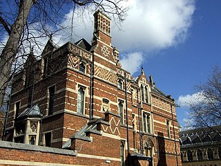
Turl Street is a historic street in central Oxford, England.

The High Street in Oxford, England, known locally as the High, runs between Carfax, generally seen as the centre of the city, and Magdalen Bridge to the east.

Queen Street is a pedestrianised shopping street in central Oxford, England. It is one-way for buses and taxis, two-way for cyclists outside main shopping hours, and forbidden for cars. It runs west from the centre of Oxford at Carfax. Here it adjoins Cornmarket Street to the north, the High Street continuing east, and St Aldate's to the south.
Museum Road is a short road in central Oxford, England. It leads to the Oxford University Museum of Natural History and the Radcliffe Science Library at its eastern end where it meets Parks Road. At its west end is a junction with Blackhall Road. It continues as the Lamb & Flag Passage past the Lamb & Flag public house on St Giles', a meeting place of J.R.R. Tolkien and the Inklings.

Magdalen Street is a short shopping street in central Oxford, England, just north of the original north gate in the city walls. Traditionally, the name of the street is pronounced and not as the name of the Magdalen College, which is always.

Abingdon Road is the main arterial road to the south of the city of Oxford, England. The road passes through the suburbs of Grandpont and New Hinksey. It is named after the town of Abingdon to the south.

Alfred Street is a street running between the High Street to the north and the junction with Blue Boar Street and Bear Lane at the southern end, in central Oxford, England. To the south is Christ Church, one of Oxford University's historic colleges.

Blue Boar Street is a narrow historic street running between St Aldate's to the west and the southern end of Alfred Street to the east, in central Oxford, England. It is located just north of Christ Church.
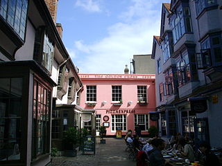
Golden Cross is a shopping arcade at 5 Cornmarket Street in central Oxford, England. The original structure on the site dates from 1193, when it was called Maugershall after the then owner, and consisted of shops with an inn on the upper storeys. The building structures now on the site date from the late 15th century, when they were used as a traditional coaching inn, as is clear from its layout and historical documents. The collection of historic buildings in the Golden Cross courtyard to the east off Cornmarket Street, one of Oxford's main shopping streets. Golden Cross is now used as Oxford's branch of Pizza Express. The courtyard is used as a thoroughfare which leads to the historic Covered Market and has been redeveloped as a small shopping centre, with upmarket shops, a branch of iGlasses Opticians, Holland and Barrett and a Chinese herbalist.

Catte Street is a historic street in central Oxford, England.

New Inn Hall Street is a street in central Oxford, England, and is one of Oxford's oldest streets. It is a shopping street running north–south parallel and to the west of Cornmarket Street, with George Street to the north and Bonn Square at the west end of Queen Street to the south. St Michael's Street leads off the street to the east near the northern end. Shoe Lane to the east leads to the Clarendon Centre, a modern shopping centre.

Brasenose Lane runs east–west in central Oxford, England, between Turl Street and Radcliffe Square respectively. From Turl Street it is only accessible to pedestrians, but vehicles can enter from Radcliffe Square. The lane retains the medieval pattern of a single drainage channel in its centre and has high stone-faced college buildings on each side, being flanked by three historic Oxford colleges.

Ship Street is a short street in central Oxford, England that runs east–west.

Wesley Memorial Church is a Methodist church in central Oxford, England. John and Charles Wesley studied in Oxford, and the congregation was founded in 1783. The present church building was completed in 1878. The building is now a focus for various social activities as well as Christian worship.

St Bernard's Road is a residential road in North Oxford, England, connecting the southern end of Kingston Road and the northern end of Walton Street, at the junction with Walton Well Road, to the west with Woodstock Road, opposite Bevington Road, to the east.

Grove Walk is a short historic leafy walkway running north–south in central Oxford, England, situated on land between Merton College to the east and Corpus Christi College to the west. It provides one of the entrances to Christ Church Meadow from the north.
The Abingdon Arms was a public house, originally a coaching inn, in Market Street, Oxford, England.
Zacharias and Co. was a waterproof clothing manufacturing firm and retailer based at 26–27 Cornmarket Street Oxford, England.


