Baltimore/Washington International Thurgood Marshall Airport, commonly referred to as BWI or BWI Marshall, is an international airport in the Eastern United States serving mainly Baltimore, Maryland, and Washington, D.C. With Dulles International Airport and Ronald Reagan Washington National Airport, it is one of three major airports serving the Baltimore–Washington, D.C. metropolitan area. Located in an unincorporated area of Anne Arundel County, the airport is 9 miles (14 km) south of Downtown Baltimore and 30 miles (48 km) northeast of Washington, D.C.

The Baltimore–Washington Parkway is a highway in the U.S. state of Maryland, running southwest from Baltimore to Washington, D.C. The road begins at an interchange with U.S. Route 50 (US 50) near Cheverly in Prince George's County at the Washington, D.C. border, and continues northeast as a parkway maintained by the National Park Service (NPS) to MD 175 near Fort Meade, serving many federal institutions. This portion of the parkway is dedicated to Gladys Noon Spellman, a representative of Maryland's 5th congressional district, and has the unsigned Maryland Route 295 (MD 295) designation. Commercial vehicles, including trucks, are prohibited within this stretch. This section is administered by the NPS's Greenbelt Park unit. After leaving park service boundaries the highway is maintained by the state and signed with the MD 295 designation. This section of the parkway passes near Baltimore–Washington International Thurgood Marshall Airport. Upon entering Baltimore, the Baltimore Department of Transportation takes over maintenance of the road and it continues north to an interchange with Interstate 95 (I-95). Here, the Baltimore–Washington Parkway ends and MD 295 continues north unsigned on Russell Street, which carries the route north into downtown Baltimore. In downtown Baltimore, MD 295 follows Paca Street northbound and Greene Street southbound before ending at US 40.

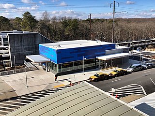
BWI Airport Station is an intermodal passenger station in Linthicum, Maryland near Baltimore–Washington International Airport (BWI). It is served by Amtrak Northeast Corridor intercity trains, MARC Penn Line regional rail trains, and several local bus lines.

Martin State Airport is a joint civil-military public use airport located nine nautical miles east of the central business district of Baltimore, in Baltimore County, Maryland, United States. The facility is located within the census-designated place of Middle River on Maryland State Highway 150, near the intersection of Maryland State Highway 700. The Maryland Aviation Administration operates the airport on behalf of the Maryland Department of Transportation. MTN is a general aviation relief airport.
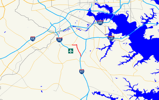
Interstate 195 (I-195) is an Interstate highway in the U.S. state of Maryland. The highway runs 4.35 miles (7.00 km) from I-95 in Arbutus east to MD 170 near the Baltimore/Washington International Thurgood Marshall Airport in Linthicum. I-195, which is also known as Metropolitan Boulevard, is the main connection between the airport terminal and highways leading to Baltimore, Washington, and Annapolis, including I-95, MD 295, and I-97. The interchange with MD 170, which forms part of the Airport Loop, provides access to various airport-related services. I-195 also links I-95 with Catonsville and the University of Maryland, Baltimore County (UMBC), via a westward continuation of Metropolitan Boulevard that is part of MD 166.

Republic Airport is a regional airport in East Farmingdale, New York, located one mile east of Farmingdale village limits.

Maryland Route 170 is a state highway in the U.S. state of Maryland. The state highway runs 12.98 miles (20.89 km) from MD 175 in Odenton north to MD 2 in Brooklyn Park. MD 170 connects the western Anne Arundel County communities of Odenton and Severn and the North County communities of Linthicum, Pumphrey, and Brooklyn Park with Baltimore/Washington International Thurgood Marshall Airport. The highway connects BWI Airport with Interstate 695 (I-695) and MD 100 and forms part of the Airport Loop, a circumferential highway that connects the airport and I-195 with many airport-related services.

Maryland Route 176 is a state highway in the U.S. state of Maryland. Known as Dorsey Road, the highway runs 5.68 miles (9.14 km) from the end of state maintenance in Hanover east to MD 648 in Glen Burnie. MD 176 is a mostly four-lane highway that parallels MD 100 and forms the southern portion of the Airport Loop, a circumferential highway around Baltimore/Washington International Thurgood Marshall Airport that connects the airport with various airport-related services. The highway serves as the main connection between the Airport Loop and Interstate 97 (I-97).

The Metropolitan Washington Airports Authority (MWAA) is an independent airport authority, created with the consent of the United States Congress to oversee management, operations, and capital development of the two major airports serving the U.S. national capital: Ronald Reagan Washington National Airport and Dulles International Airport.
The Baltimore–Washington Superconducting Maglev Project (SCMAGLEV) is a proposed project connecting the United States cities of Baltimore, Maryland, and Washington, D.C., with a 40 mi (64 km) maglev train system between their respective central business districts. It is the first segment of the planned Washington-New York Northeast Maglev project. The maglev proposal is not related to the Baltimore–Washington hyperloop proposed by the Boring Company.

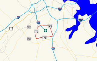
Airport Loop is the designation for the portions of state highways that form a circumferential highway around Baltimore/Washington International Thurgood Marshall Airport in Anne Arundel County in the U.S. state of Maryland. The loop runs 8.44 miles (13.58 km) through the communities of Linthicum, Ferndale, and Hanover. Airport Loop consists of a 3.47-mile (5.58 km) section of Maryland Route 170 (MD 170) along the western and northern sides of the loop; the entire 2.31-mile (3.72 km) length of MD 162 on the eastern side of the loop; and a 2.66-mile (4.28 km) segment of MD 176 on the southern side of the loop. Airport Loop intersects Interstate 195 (I-195), which provides freeway access to the airport terminal, and is connected to I-695, I-97, and MD 100 via connecting highways. The MD 170 and MD 162 sections of Airport Loop are part of the National Highway System.

The Maryland Transportation Authority Police is the eighth-largest law enforcement agency in the U.S. state of Maryland and is charged with providing law enforcement services on Maryland Transportation Authority highways and facilities throughout the Maryland, in addition to contractual services that are provided at Baltimore–Washington International Thurgood Marshall Airport, and the Port of Baltimore.

Maryland Route 162 is a state highway in the U.S. state of Maryland. Known as Aviation Boulevard, the highway runs 2.31 miles (3.72 km) from MD 176 near Ferndale north to MD 170 in Linthicum in northern Anne Arundel County. MD 162 forms the eastern portion of the Airport Loop that circumscribes Baltimore/Washington International Thurgood Marshall Airport and connects the airport with Interstate 97 (I-97). Most of what is now MD 162 was Maryland Route 167 in the late 1960s and early 1970s; MD 167 previously had been assigned to a different portion of Hammonds Ferry Road in Linthicum from the 1930s to the early 1960s. MD 162 was assigned along the length of MD 167's second route in the late 1980s and immediately relocated at its northern end. The remainder of the highway was expanded to a divided highway in the 1990s.

Carroll County Regional Airport, also known as Jack B. Poage Field, is a public airport located three miles (5 km) north of the central business district of Westminster, in Carroll County, Maryland, United States. The airport is owned by Carroll County Board of Commissioners. It is designated as a reliever airport for the Baltimore-Washington International Thurgood Marshall Airport (BWI).

BWI Airport station is a Baltimore Light Rail station at the Baltimore-Washington International Airport in Maryland. It is one of the two southern terminals of the Baltimore Light Rail. The station platforms are just outside an entrance to the International Concourse on the lower level.

Hagerstown Regional Airport is in Washington County, Maryland, five miles north of Hagerstown, Maryland and a half mile from the Maryland/Pennsylvania border. The airport is off Interstate 81 at exit 10 and U.S. Route 11, not far from Northern Virginia, South Central Pennsylvania, and the Eastern Panhandle of West Virginia.

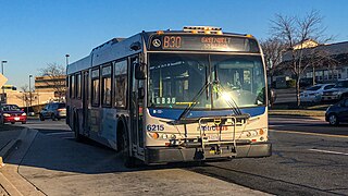
The Greenbelt–BWI Thurgood Marshall Airport Express Line, designated Route B30, is a weekday-only bus route operated by the Washington Metropolitan Area Transit Authority between Baltimore-Washington International Thurgood Marshall Airport and the Greenbelt station of the Green and Yellow Lines of the Washington Metro. The line operates every 70 minutes five days a week along the Baltimore–Washington Parkway between these two locations with no intermediate stops, with the exception of the BWI Business District Light Rail Stop and Arundel Mills Mall, and the last bus leaving BWI at 10:09 pm. The trip is approximately 50 minutes long.

Maryland's first aeronautical event was the flight of 13-year-old Edward Warren from Baltimore in Peter Carne's tethered hot air balloon in 1784.

The BWI Business District is a neighborhood and business district in Linthicum and Hanover that features over 11,000 hotel rooms and numerous office parks and shopping centers. As the name suggests, the business district is benefited by nearby Baltimore-Washington International Airport.
The BWI Marshall Airport Shuttle is a free bus service provided by Baltimore–Washington International Airport, that connects the airport terminal to BWI Rail Station. The free shuttle connects airport passengers to Amtrak and MARC trains, hence connecting the airport to Baltimore and Washington, D.C., as well as the rest of the Northeastern United States.


