Related Research Articles

Bay View is a census-designated place (CDP) in Skagit County, Washington, United States. The population was 696 at the 2010 census. It is included in the Mount Vernon–Anacortes, Washington Metropolitan Statistical Area.
Goose Island is one of the San Juan Islands in San Juan County, Washington, United States.
The Quimper Peninsula is a narrow peninsula forming the most northeastern extent of the Olympic Peninsula of Washington state in the northwestern United States of America.

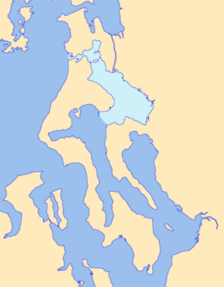
Padilla Bay is a bay located in the U.S. state of Washington, between the San Juan Islands and the mainland. Fidalgo Island and Guemes Island lie to the west of Padilla Bay. Guemes Channel, between the islands, connects Padilla Bay to Rosario Strait. Samish Island lies to the north of Padilla Bay, beyond which is Samish Bay and Bellingham Bay.

Port Gardner, also known as Port Gardner Bay, is an inlet of Possession Sound on which the city of Everett, Washington is located. The Snohomish River flows into the north end of the bay.
Skull Island is the name of two small islands in the San Juan Archipelago in the U.S. state of Washington. The northernmost Skull Island is located off the coast of Orcas Island in Massacre Bay, the most northern extension of the island's West Sound. It is identified as 3.2-acre (1.3 ha) Skull Island State Park Property by the Washington State Parks and Recreation Commission. It was named for holding skulls and bones of a band of Lummi who were killed by raiding Haida in 1858. Since 2013, it has been part of the San Juan Islands National Monument.

Semiahmoo Bay is the southeastern section of Boundary Bay on the Pacific coast of North America. The bay is named for the Semiahmoo First Nation, who originally occupied the area. The Semiahmoo Peninsula borders the bay and was home to cannery operations. It is now home to the Semiahmoo Golf Resort.
Colville Island is an island in the San Juan Islands of the U.S. state of Washington. It lies near Point Colville, on the southeastern tip of Lopez Island.

Skagit Bay is a bay and strait located in the U.S. state of Washington. It is part of the Whidbey Island Basin of Puget Sound. The Skagit River empties into Skagit Bay. To the south, Skagit Bay connects with the rest of Puget Sound via Saratoga Passage and Possession Sound. The boundary between Saratoga Passage and Skagit Bay is between Polnell Point on Whidbey Island and Rocky Point on Camano Island. To the northwest, Skagit Bay connects to the Strait of Juan de Fuca via the narrow strait of Deception Pass. A third waterway, the Swinomish Channel, connects Skagit Bay with Padilla Bay to the north.
Port Susan is a bay and strait located in the U.S. state of Washington. Part of the Whidbey Island Basin of Puget Sound, Port Susan is bounded by Camano Island to the west and the mainland to the east. The Stillaguamish River empties into the northern end of Port Susan. To the south, Port Susan connects with the rest of Puget Sound via Possession Sound and Saratoga Passage. A swampy waterway connects the northern end of Port Susan with Skagit Bay. This waterway also separates Camano Island from the mainland.
Griffin Bay State Park in San Juan County, Washington was a marine park with two campsites in the Washington State Parks. It consisted of 15 acres (6.1 ha) with 340 feet (100 m) of saltwater shoreline. It was part of the Cascadia Marine Trail and campsites were restricted to visitors arriving by human- and wind-powered watercraft. Though the state parks department still owned the land as of August, 2014, the park is no longer listed on the state parks website.

The Swinomish Channel is an 11-mile (18 km) long salt-water channel in Washington state, United States, which connects Skagit Bay to the south and Padilla Bay to the north, separating Fidalgo Island from mainland Skagit County. The Swinomish Channel is the smallest of the three entrances to Puget Sound—the other two being Deception Pass and Admiralty Inlet.

Bowman Bay is a bay in the state of Washington, United States. It was formerly called Reservation Bay, having been part of a military reservation. In 1977 it was given its current name in honor of Amos Bowman, an American settler of nearby Fidalgo Island. The name of Anacortes on Fidalgo Island is derived from the name of Bowman's wife, Anna Curtis.
Cornet is an unincorporated community in Island County, in the U.S. state of Washington.
Cornet Bay is a bay in the U.S. state of Washington.
Fidalgo is an unincorporated community in Skagit County, in the U.S. state of Washington.
Lawrence is an unincorporated community in Whatcom County, in the U.S. state of Washington.
Noon is an unincorporated village in Whatcom County, in the U.S. state of Washington.

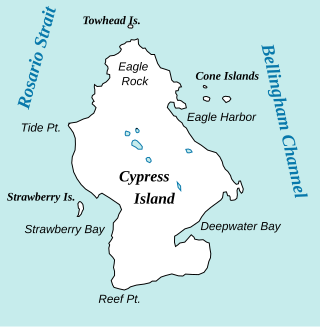
Deepwater Bay is a saltwater bay of the Salish Sea on the southeast side of Cypress Island in the U.S. state of Washington. It was the site of an unintentional release of aquaculture-raised Atlantic salmon in 2017, the Cypress Island Atlantic salmon pen break, initially blamed on the Solar eclipse of August 21, 2017.
References
- ↑ U.S. Geological Survey Geographic Names Information System: Massacre Bay (Washington)
- ↑ Meany, Edmond S. (1923). Origin of Washington geographic names. Seattle: University of Washington Press. p. 161.