
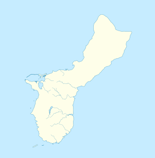
Guam is an organized, unincorporated territory of the United States in the Micronesia subregion of the western Pacific Ocean. It is the westernmost point and territory of the United States; in Oceania, it is the largest and southernmost of the Mariana Islands and the largest island in Micronesia. Guam's capital is Hagåtña, and the most populous city is Dededo.

The Mariana and Palau Islands campaign, also known as Operation Forager, was an offensive launched by United States forces against Imperial Japanese forces in the Mariana Islands and Palau in the Pacific Ocean between June and November 1944 during the Pacific War. The United States offensive, under the overall command of Chester Nimitz, followed the Gilbert and Marshall Islands campaign and was intended to neutralize Japanese bases in the central Pacific, support the Allied drive to retake the Philippines, and provide bases for a strategic bombing campaign against Japan.

USS Wake (PR-3) was a United States Navy river gunboat operating on the Yangtze River, that was captured by Japan on 8 December 1941.

The 3rd Marine Division is an infantry division of the United States Marine Corps based at Camp Courtney, Marine Corps Base Camp Smedley D. Butler and Okinawa, Japan. It is one of three active duty infantry divisions in the Marine Corps and together with the 1st Marine Aircraft Wing (1stMAW) and the 3rd Marine Logistics Group forms the III Marine Expeditionary Force. The division was first formed during World War II and saw four years of continuous combat in the Vietnam War. Today, elements of the 3rd Marine Division are continuously forward deployed and forward postured to carry out the US Government's mission of a Free and Open Indo-Pacific in conjunction with its sister services.

The War in the Pacific National Historical Park is a multi-unit protected area in the United States territory of Guam, which was established in 1978 in honor of those who participated in the Pacific Theater of World War II. Uniquely among the National Park System, it honors the bravery and sacrifices of all those who participated in the Pacific Theater.

The Legislature of Guam is the law-making body for the United States territory of Guam. The unicameral legislative branch consists of fifteen senators, each serving for a two-year term. All members of the legislature are elected at-large with the island under one whole district. After the enactment of the Guam Organic Act in 1950, the First Guam Legislature was elected composing of 21 elected members. Today, the current fifteen-member 36th Guam Legislature was elected in November 2020.

USS Kenton (APA-122) was a Haskell-class attack transport of the US Navy. She was built and used during World War II. She was of the VC2-S-AP5 Victory ship design type. She was named for Kenton County, Kentucky.
The 21st Marine Regiment was an infantry regiment of the United States Marine Corps. Activated for service in World War II, they fought in the battles of Bougainville, Guam and Iwo Jima. They fell under the 3rd Marine Division and were deactivated after the end of the war on December 20, 1945.
USS LST-900 was an LST-542-class tank landing ship in the United States Navy during World War II. Late in her career, she was renamed Linn County (LST-900)—after counties in Iowa, Kansas, Missouri, and Oregon—but saw no active service under that name.
USS Lyon County (LST-904) was an LST-542-class tank landing ship built for the United States Navy during World War II. Named after counties in Iowa, Kansas, Kentucky, Minnesota, and Nevada, she was the only U.S. Naval vessel to bear the name.
Guam The following outline is provided as an overview of and topical guide to Guam:

The following is an alphabetical list of articles related to the United States Territory of Guam.
The Ramu languages are a family of some thirty languages of Northern Papua New Guinea. They were identified as a family by John Z'graggen in 1971 and linked with the Sepik languages by Donald Laycock two years later. Malcolm Ross (2005) classifies them as one branch of a Ramu – Lower Sepik language family. Z'graggen had included the Yuat languages, but that now seems doubtful.

The Hagåtña River is a river in the United States territory of Guam. Hagåtña, the capital of Guam, is located at the mouth of the river and associated wetlands form the eastern boundary of the city. The river mouth is depicted on both the Seal of Guam and Flag of Guam. The river used to substantially parallel the shoreline, with the river emptying into the sea west of the current Paseo de Susana and marina. However, following the devastation of the U.S. bombardment during the 1944 battle, U.S. Navy Seabees rerouted the river to its current, more direct course to the sea. This resulted in landmarks such as the Agana Spanish Bridge no longer having water flow beneath it.

The Agat World War II Amtrac is an underwater relic of World War II, located off Ga'an Point in Agat Bay on the west side of the island of Guam. It is the remains of an LVT 4, an amphibious tracked landing vehicle. It is located about 500 yards (460 m) off Agat Invasion Beach in 45 feet (14 m) of water, and was described as being in good condition when it was discovered and surveyed in 1985. These vehicles were used during the 1944 Battle of Guam, in which American forces recaptured the island from occupying Japanese forces. This particular vehicle does not appear to exhibit significant war damage. This is the most intact of the three Amtracks remaining on Guam from the 850 that participated in the battle. It was re-surveyed by maritime archaeological field schools conducted from 2009 to 2012.
The Matgue River Valley Battle Area was the site of a decisive Allied victory during the 1944 Battle of Guam. The area was the scene of a major counterattack by Japanese forces against the Allied beachhead, in which the Japanese suffered extremely heavy casualties and were beaten back. After this attack, the remaining Japanese forces on the island retreated to the north. The area is located in the hills southwest of Asan Point along the Matgue River. The only surviving structural remnants associated with the battle are caves dug by the Japanese as defensive positions prior to the invasion.
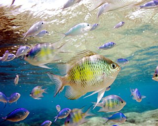
Piti Bomb Holes Marine Preserve is a marine protected area comprising all of Piti Bay on the western coast of Guam, located off of the village of Piti in the Philippine Sea. The defining "bomb hole" features, named because they look like bomb craters in the reef flat, are actually natural percolation pits where fresh water filters into the shallow lagoon at a depth of 25 to 30 feet. The largest pit houses the commercial Fish Eye Marine Park tourist attraction, which includes a wooden pier to a underwater observatory and a Seawalker tour of the lagoon bottom. It is visited by more than 200,000 people annually. The Piti preserve is the most ecologically diverse of Guam's five marine preserves. The pit around Fish Eye is a popular snorkeling and recreational diving site.
