In Canada, National Airport System is a group of major airports defined in the National Airports Policy published in 1994. It was intended to include all airports with an annual traffic of 200,000 passengers or more, as well as airports serving the national, provincial and territorial capitals.
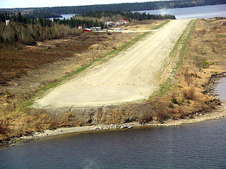
Little Grand Rapids Airport is the airport serving the First Nations communities of Little Grand Rapids and the nearby Pauingassi First Nation, Manitoba, Canada. These two communities are connected to the more populated southern areas of Manitoba by a winter road which is only operational for about two months per year. During the other 10 months, this airport is the only practical way move passengers and goods in and out of the communities. The lack of roads and small size of aircraft, typically Otters, Grand Caravans or similar, makes it relatively busy compared to the population of roughly 1,500 served by the airport.
St. Theresa Point Airport is located on St Mary Island 0.8 nautical miles north of St. Theresa Point, Manitoba, Canada.
Bloodvein River Airport is located adjacent to Bloodvein River, Manitoba, Canada and serves the Bloodvein First Nation.
Cross LakeAirport is located 1 nautical mile east of Cross Lake, Manitoba, Canada.
Elk Island Airport is located on Elk Island in Gods Lake, Manitoba, Canada.

Flin Flon Airport is located 8 nautical miles southeast of Flin Flon, Manitoba, Canada, in the community of Bakers Narrows, on the shores of Lake Athapapuskow.

Island Lake Airport or Island Lake — Garden Hill Airport is located 5 nautical miles southwest of Island Lake, Manitoba, Canada.

Thompson Municipal Airport is an airport in Mystery Lake located 3 nautical miles north of Thompson, Manitoba, Canada. It is the third-busiest airport in Manitoba after Winnipeg James Armstrong Richardson International Airport and Winnipeg/St. Andrews Airport.

Winnipeg/St. Andrews Airport or St. Andrews Airport is a general aviation facility located 10 nautical miles north-northeast of Winnipeg, in the Rural Municipality of St. Andrews, Manitoba, Canada. In 2022 it was Canada's 11th busiest airport by aircraft movements.

