
Anantnag district is a district in the Indian union territory of Jammu and Kashmir. It is one of ten districts which make up the Kashmir Valley. The district headquarters is Anantnag city. As of 2011, it was the third most populous district of Jammu and Kashmir, after Jammu and Srinagar.

The Pulwama district is located to the south of Srinagar in Indian-administered Kashmir. Its district headquarters are situated in the city of Pulwama. It is located in the central part of the Kashmir Valley.
Pulwama is a city and notified area council in the Pulwama district of the Indian union territory of Jammu and Kashmir. It is located approximately 25 kilometres (16 mi) south of the summer capital of the state, Srinagar.
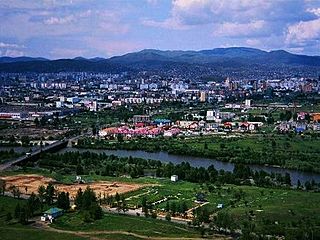
Anantnag, also called Islamabad, is the administrative headquarters of the Anantnag district in the Indian union territory of Jammu and Kashmir. It is located at a distance of 53 kilometres from the union territory's capital Srinagar. It is the third largest city in Jammu and Kashmir after Srinagar and Jammu with an urban agglomerate population of 159,838 and municipal limit population of 109,433.

Achabal, known as Achival in Kashmiri, is a town in Anantnag district, in the union territory of Jammu and Kashmir, India.

Banihal local pronunciation[ banhal ]is a town and a notified area committee, near Ramban town in Ramban district in the Indian union territory of Jammu and Kashmir. It is a rural and hilly area with Kamirwah being one of the most prominent hills. It is located about 35 km (22 mi) away from Qazigund of Anantnag district on NH 44. However, the distance between Banihal and Qazigund is only 18 km by train on the new railway line which is much shorter than the road. The most common language spoken in the region is Kashmiri; Urdu, Hindi, Gujjari, Pahari and English being other familiar languages. Banihal forms the main gateway to the valley of Kashmir. Some famous visiting places in banihal are Neel top and Mahu valley.

Ganderbal is a town and a municipality committee in Ganderbal district in the Indian union territory of Jammu and Kashmir. It is the headquarters of Ganderbal district.It is in Central Kashmir, it has an average elevation of 1,619 metres. It is bordered by district Srinagar in the south, Bandipore to the north, Kargil in the northeast, Anantnag to the south-east and Baramulla in the south-west.The current District Magistrate of Ganderbal is Mr. Shyambir Singh.District Ganderbal is known for its beauty,there are many beautiful places in Ganderbal.Sonmarg is the most famous place in Ganderbal, Shri Amarnath Ji Yatra is also done in Ganderbal.
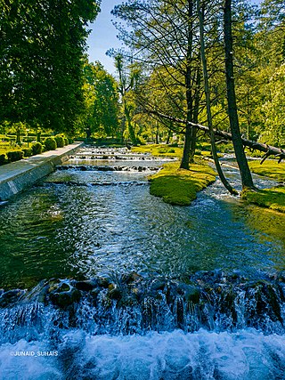
Kokernag is a sub-district town and a notified area committee in Breng Valley, Anantnag district in the Indian union territory of Jammu and Kashmir. The place is known for the botanical gardens, pristine freshwater springs, and rainbow trout farm. It is 25.3 km from Anantnag via NH244. It is one of the most popular weekend getaways from the state capital of Srinagar.
Pahalgam, known as Pahalgom is a town and a notified area committee, near Anantnag city in the Anantnag district of the Indian-administered union territory of Jammu and Kashmir. It is a popular tourist destination and hill station. Its lush green meadows and pristine waters attract thousands of tourists from all over the world each year. It is located 45 kilometres (28 mi) from Anantnag on the banks of Lidder River at an altitude of 7,200 feet (2,200 m). Pahalgam is the headquarters of one of the eleven tehsils of Anantnag district.

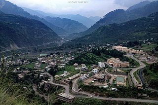
Qazigund, also known as Gateway Of Kashmir, is a town and in the union territory of Jammu and Kashmir, India. Qazigund is located at 33.59°N 75.16°E. It has an average elevation of 1670 m (5478 feet) above mean sea level.

Shopian or Shupiyan, known as Shupyan in Kashmiri, is an administrative division of the Shopian district, located in southern part of Kashmir Valley, of Jammu and Kashmir, India. Shopian is called the ''Apple town of Kashmir'' as majority of the population engages in apple growing practices which also provides employment to more than 60% of the population. It is 2nd richest district in Kashmir region after Srinagar.

Budgam district is a district in the Indian union territory of Jammu and Kashmir. Created in 1979 with its headquarters at the town of Budgam, it is the district with the largest population of Shia Muslims in the Kashmir valley.
Ramban district is a district in the Indian union territory of Jammu and Kashmir, located in the lap of the Pir Panjal range. It was carved out as a separate district from erstwhile Doda district in 2007. It is located in the Jammu division. The district headquarters are at Ramban town, which is located midway between Jammu and Srinagar along the Chenab river in the Chenab valley on National Highway-44, approximately 151 km from Jammu and Srinagar.
Kangan is a town located near Ganderbal, in the Ganderbal district of Jammu and Kashmir, India. It is one of the tehsils in District Ganderbal. It is situated across the Nallah Sindh and spread over a 50-km-long gorge valley, with population of 120,934 and literacy rate of 52.8% and sex ratio 868 per thousand males. Widely regarded for its beauty, it is surrounded by various picnic spots like Sonamarg and Naranag.

Fatehpora also known as Fateh Pora & Fatehpura, is an economic hub area of Anantnag district in the union territory of Jammu and Kashmir, India. Fatehpora is located at 33.656027°N 75.160375°E. It has an average elevation of 1600 metres (5478 feet) above mean sea level.
Dialgam is a large village situated in Anantnag tehsil, in Anantnag district of Jammu and Kashmir. It is one of 150 villages in Anantnag Block along with villages like Hardu Shichan and Pal Pora.

Akingam is a village in South Kashmir in the Anantnag district, in the Indian union territory of Jammu and Kashmir. It is at a distance of approximately 14.2 kilometres (8.8 mi) from the Lal Chowk along a route passing through the tourist resorts of Achabal and Kokernag. In revenue records, the village of Akingam is still called Maqan Shiva Bhagwati. The adjacent villages are Mohripura, Hiller, Badasgam, Hardpora and Badoora.
Shankerpora, also known as Shankerpur, is a village in Anantnag district in the Indian-administered union territory of Jammu and Kashmir.

Padgampora, also known as Padgampur, is a village in Awantipora tehsil in Pulwama district of Indian adminestered Jammu and Kashmir. It is located 14 km (8.7 mi) towards East from District headquarters Pulwama. 14 km (8.7 mi) from Tral. 25 km from State capital Srinagar.
Gadiseer is a village in the Anantnag district in the Indian administered union territory of Jammu and Kashmir. It is located on the bank of Jhelum River. PIN code of Gadiseer is 192124 and its postal head office is Bijbehara. The village falls in the vicinity (jurisdiction) of tehsil Bijbehara in Dachnipora Block.


