
Jim Thorpe is a borough and the county seat of Carbon County in the U.S. state of Pennsylvania. It is part of Northeastern Pennsylvania. It is historically known as the burial site of Native American sports legend Jim Thorpe.

Summit Hill is a borough in Carbon County, Pennsylvania, United States. It is part of Northeastern Pennsylvania. The population was 3,034 at the 2010 census.

Hurricane Agnes was the costliest hurricane to hit the United States at the time, causing an estimated $2.1 billion in damage. The hurricane's death toll was 128. The effects of Agnes were widespread, from the Caribbean to Canada, with much of the east coast of the United States affected. Damage was heaviest in Pennsylvania, where Agnes was the state's wettest tropical cyclone. Due to the significant effects, the name Agnes was retired in the spring of 1973.
The South Fork Dam was an earthenwork dam forming Lake Conemaugh, an artificial body of water near South Fork, Pennsylvania, United States. On May 31, 1889, the South Fork Dam failed catastrophically and 20 million tons of water from Lake Conemaugh burst through and raced 14 miles (23 km) downstream, causing the Johnstown Flood.
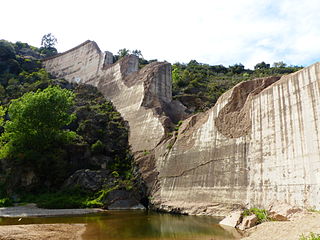
The Malpasset Dam was an arch dam on the Reyran River, north of Fréjus on the French Riviera. It collapsed on 2 December 1959, killing 423 people in the resulting flood. The breach was caused by a tectonic fault in the impermeable rock base, which had been inadequately surveyed. Nearby road-building works, using explosives, may also have contributed to the disaster.

The Lehigh Canal is a navigable canal that begins at the mouth of Nesquehoning Creek on the Lehigh River in the Lehigh Valley and Northeastern regions of Pennsylvania. It was built in two sections over a span of 20 years beginning in 1818. The lower section spanned the distance between Easton and present-day Jim Thorpe. In Easton, the canal met the Delaware and Morris Canals, which allowed anthracite coal and other goods to be transported further up the U.S. East Coast. At its height, the Lehigh Canal was 72 miles (116 km) long.

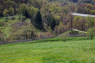
Lehigh Gorge State Park is a 4,548 acres (1,841 ha) Pennsylvania state park in Luzerne and Carbon Counties, Pennsylvania. The park encompasses a gorge, which stretches along the Lehigh River from a U.S. Army Corps of Engineers flood control dam in Luzerne County to Jim Thorpe in Carbon County. The primary recreational activity at Lehigh Gorge State Park is white water rafting.

In early periods of North American industrial development, an ark was a temporary boat used for river transport in eastern North America before slack-water canals and railroads made them obsolete. Because they could be built using relatively crude hand tools, arks were built in American colonial and early republic times, primarily to carry cargo downriver on the spring freshets, and especially to carry milled lumber, charcoal and other forest products and bulk agricultural produce to a city or a port downriver. While logs were often tied into rafts, on long trips which could take weeks, the rafts would be accompanied by such arks as crew support quarters. Deep rivers allowed large log arks as described below instead of less controllable rafts. Since by 1800, most eastern towns and cities were short on heating fuels, even badly processed timber or planks could readily be sold at the destinations.
Green River Lake is a 8,210-acre (33 km2) reservoir in Adair, Taylor, and Casey counties in Kentucky lying in the section of Kentucky known as the Highland Rim.
Mauch Chunk Creek is a 9.2-mile-long (14.8 km) tributary of the Lehigh River in Carbon County, Pennsylvania in the United States.
Scherersville is an unincorporated community in Lehigh County, Pennsylvania. It is located on Jordan Creek, mainly in South Whitehall Township and also in Whitehall Township. Schereresville is part of the Lehigh Valley, which has a population of 861,899 and is the 68th-most populous metropolitan area in the U.S. as of the 2020 census.

Pisgah Mountain or Pisgah Ridge is a ridgeline running 12.5 miles (20.1 km) from Tamaqua to Jim Thorpe, Pennsylvania. It is oriented north-northeast to south-southwest, and its north-side valley is followed by U.S. Route 209 from river gap to river gap. The ridge is a succession of peaks exceeding 1,440 feet (438.9 m) rising 300 to 540 feet above the boroughs of Lansford, Coaldale, and Tamaqua in the Panther Creek valley. The highest point on Pisgah Mountain is at 1,611 feet (491 m) in the borough of Summit Hill, which sits atop the ridge. Near Summit Hill was the "Sharpe Mountain" (peak) where in 1791 Phillip Ginter is documented as having discovered anthracite, leading to the formation of the Lehigh Coal Mine Company. In 1818 the Lehigh Coal Company took over the mines, and the mining camp gradually became a settlement and grew into Summit Hill.
Mount Pisgah is a peak in Carbon County, Pennsylvania situated north-northwest from and looming over the right bank business district in downtown Jim Thorpe.
Nesquehoning Mountain or Nesquehoning Ridge is a 15–17-mile-long (24–27 km) coal bearing ridge dividing the waters of Lehigh Valley to the north from the Schuylkill River valley and the several near parallel ridgelines of the Ridge-and-valley Appalachians barrier range all local members of which run generally WSW-ENE in the greater overall area.
East Mauch Chunk is a former independent borough in Carbon County, Pennsylvania, United States. Located along the east bank of the Lehigh River on the opposite bank from the town business district, it was part of Northeastern Pennsylvania.
The Hauto Tunnel, dug in 1871–72, was a 1.1-mile-long (1.8 km) single-track railway tunnel crossing under the barrier ridge of Nesquehoning Mountain between Lansford, Pennsylvania, in the Panther Creek Valley and the Central Railroad of New Jersey trackage near the dam of the Hauto Reservoir impoundment about 1.3 miles (2.1 km) above Nesquehoning, Pennsylvania. The tunnel was significant for cutting nearly 15 difficult mountainous miles (24 km) off the trip to the Lehigh Canal terminal or, by rail, to other eastern coal companies, in the era when anthracite was the king of energy fuels.

Bear Mountain, in the Lehigh Valley of Pennsylvania several miles above the Lehigh Gap, is a steep-sided east bank ridgeline running about 9.96 miles (16.03 km) between the hairpin turn in the Lehigh the Lenape Amerindian people visualized as a bear's snout, along many water gap gorges, to the steep face dropping down to the Penn Forest Reservoir.

Lausanne, alternately named Lausanne Landing of the 1790s–1820s was a small settlement at the mouth of Nesquehoning Creek on the Lehigh River in marshy delta-like flood plain. Some historic references will mention the presence of a 'Landing Tavern' as the entirety of the town. Lausanne township was originally organized out of dense wilderness along an ancient Amerindian Trail, the "Warriors' Path" an important regional route as it connected the Susquehanna River settlements of the lower Wyoming Valley to those around Philadelphia.
The Mauch Chunk Opera House, formerly known as the Capitol Theater, is a theatre in Jim Thorpe, Pennsylvania in the United States.

