
The Taupō Volcanic Zone (TVZ) is a volcanic area in the North Island of New Zealand that has been active for at least the past two million years and is still highly active. Mount Ruapehu marks its south-western end and the zone runs north-eastward through the Taupō and Rotorua areas and offshore into the Bay of Plenty. It is part of a larger Central Volcanic Region that extends to the Coromandel Peninsula and has been active for four million years. The zone is contained within the tectonic intra-arc continental Taupō Rift and this rift volcanic zone is widening unevenly east–west with the greatest rate of widening at the Bay of Plenty coast, the least at Mount Ruapehu and a rate of about 8 mm (0.31 in) per year at Taupō. The zone is named after Lake Taupō, the flooded caldera of the largest volcano in the zone, the Taupō Volcano and contains a large central volcanic plateau as well as other landforms.

The Lassen volcanic area presents a geological record of sedimentation and volcanic activity in and around Lassen Volcanic National Park in Northern California, U.S. The park is located in the southernmost part of the Cascade Mountain Range in the Pacific Northwest region of the United States. Pacific Oceanic tectonic plates have plunged below the North American Plate in this part of North America for hundreds of millions of years. Heat and molten rock from these subducting plates has fed scores of volcanoes in California, Oregon, Washington and British Columbia over at least the past 30 million years, including these in the Lassen volcanic areas.

Mount Jefferson is a stratovolcano in the Cascade Volcanic Arc, part of the Cascade Range in the U.S. state of Oregon. The second highest mountain in Oregon, it is situated within Linn County, Jefferson County, and Marion County and forms part of the Mount Jefferson Wilderness. Due to the ruggedness of its surroundings, the mountain is one of the hardest volcanoes to reach in the Cascades. It is also a popular tourist destination despite its remoteness, with recreational activities including hiking, backpacking, mountaineering, and photography. Vegetation at Mount Jefferson is dominated by Douglas fir, silver fir, mountain hemlock, ponderosa pine, lodgepole pine, and several cedar species. Carnivores, insectivores, bats, rodents, deer, birds, and various other species inhabit the area.

Mount Tehama is an eroded andesitic stratovolcano in the Cascade Volcanic Arc and the Cascade Range in Northern California. Part of the Lassen volcanic area, its tallest remnant, Brokeoff Mountain, is itself the second highest peak in Lassen Volcanic National Park and connects to the park's highest point, Lassen Peak. Located on the border of Tehama County and Shasta County, Brokeoff's peak is the highest point in the former. The hikers that summit this mountain each year are treated to "exceptional" views of Lassen Peak, the Central Valley of California, and many of the park's other features. On clear days, Mount Shasta can also be seen in the distance.

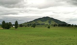
Mount Pirongia is an extinct stratovolcano located in the Waikato region of New Zealand's North Island. It rises to 959 m (3,146 ft) and is the highest peak in the Waikato region. Pirongia's many peaks are basaltic cones created by successive volcanic eruptions between the late Pliocene and early Pleistocene, about 2.5 million years ago. In the adjacent picture, the characteristic profile of the mountain can be seen, along with a prominent accessory cone to the right.

Lonquimay Volcano is a stratovolcano of late-Pleistocene to dominantly Holocene age, with the shape of a truncated cone. The cone is largely andesitic, though basaltic and dacitic rocks are present. It is located in the La Araucanía Region of Chile, immediately SE of Tolhuaca volcano. Sierra Nevada and Llaima are their neighbors to the south. The snow-capped volcano lies within the protected area Malalcahuello-Nalcas.

The volcanism of New Zealand has been responsible for many of the country's geographical features, especially in the North Island and the country's outlying islands.
Mount Labo, is a potentially active stratovolcano in the province of Camarines Norte, in the Bicol Region (Region V), on Luzon Island, in the Philippines. It is located at the northwest end of the Bicol Peninsula.

The Auckland Region of New Zealand is built on a basement of greywacke rocks that form many of the islands in the Hauraki Gulf, the Hunua Ranges, and land south of Port Waikato. The Waitākere Ranges in the west are the remains of a large andesitic volcano, and Great Barrier Island was formed by the northern end of the Coromandel Volcanic Zone. The Auckland isthmus and North Shore are composed of Waitemata sandstone and mudstone, and portions of the Northland Allochthon extend as far south as Albany. Little Barrier Island was formed by a relatively isolated andesitic volcano, active around 1 to 3 million years ago.
The Waikato and King Country regions of New Zealand are built upon a basement of greywacke rocks, which form many of the hills. Much of the land to the west of the Waikato River and in the King Country to the south has been covered by limestone and sandstone, forming bluffs and a karst landscape. The volcanic cones of Karioi and Pirongia dominate the landscape near Raglan and Kawhia Harbours. To the east, the land has been covered with ignimbrite deposits from the Taupō Volcanic Zone. Large amounts of pumice from the Taupō Volcanic Zone have been deposited in the Waikato Basin and Hauraki Plains.
Kakepuku is a volcanic cone which rises from the plain between the Waipā and Puniu rivers, about 3 km (2 mi) NW of Te Kawa and 8 km (5 mi) SW of Te Awamutu in the Waikato region of New Zealand's North Island.
Rakataura, also known as Hape or Rakatāura, is a legendary Polynesian navigator and a progenitor of many Māori iwi. Born in Hawaiki, Rakataura was the senior tohunga (priest/navigator) who led the Tainui migratory canoe to New Zealand. Rakataura is associated with stories involving the Manukau Harbour, the Te Tō Waka and the Waikato. Many place names in Tāmaki Makaurau and the Waikato region reference Rakataura, or are described in oral traditions as being named by Rakataura.

The Mangakino caldera complex is the westernmost and one of oldest extinct rhyolitic caldera volcanoes in the Taupō Volcanic Zone of New Zealand's North Island. It produced about a million years ago in the Kidnappers eruption of 1,200 km3 (287.9 cu mi), the most widespread ignimbrite deposits on Earth being over 45,000 km2 (17,000 sq mi) and was closely followed in time by the smaller 200 km3 (48.0 cu mi) Rocky Hill eruption. The Kidnappers eruption had a estimated VEI of 8 and has been assigned a total eruption volume of 2,760 km3 (662.2 cu mi).

The Hauraki Rift is an active NeS-to NWeSE-striking rift valley system in the North Island of New Zealand that has produced the Firth of Thames and the Hauraki Plains. It is approximately 25 kilometres (16 mi) wide and 250 kilometres (160 mi) long.

The extinct Ngatutura volcanic field that was active between 1.54 and 1.83 million years ago is one of four volcanic fields in an intraplate back arc relationship with the still active Hauraki Rift and the presently dormant Auckland volcanic field. The other volcanic fields, which are part of the Auckland Volcanic Province, are the oldest, Okete to the south near Raglan in late Pliocene times. and to the north the younger South Auckland volcanic field.
Pureora is an extinct 1,165 metres (3,822 ft) high basaltic andesite stratovolcano located in the Pureora Forest Park between Lake Taupō and Te Kūiti on the North Island Volcanic Plateau in New Zealand. The area of the mountain is in a scenic reserve that is "recognised as one of the finest rain forests in the world".
The Alexandra Volcanic Group is a chain of extinct calc-alkalic basaltic stratovolcanoes that were most active between 2.74 and 1.60 million years ago but is now known to have had more recent activity between 1.6 and 0.9 million years ago. They extend inland from Mount Karioi near Raglan with Mount Pirongia being the largest, with Pukehoua on the eastern slopes of Pirongia, Kakepuku, Te Kawa, and Tokanui completing the definitive lineament. The associated, but usually separated geologically basaltic monogenetic Okete volcanic field, lies mainly between Karioi and Pirongia but extends to the east and is quite scattered.
The Tauranga Volcanic Centre is a geologic region in New Zealand's Bay of Plenty. It extends from the southern end of Waihi Beach and from the old volcanoes of the Coromandel Peninsula that make up the northern part of the Kaimai Range, towards the Taupō Volcanic Zone.

The Coromandel Volcanic Zone (CVZ) is an extinct intraplate volcanic arc stretching from Great Barrier Island in the north, through the Coromandel Peninsula, to the Kaimai Range in the south. The area of transition between it and the newer and still active Taupō Volcanic Zone is now usually separated and is called the Tauranga Volcanic Centre. Its volcanic activity was associated with the formation and most active period of the Hauraki Rift.
Much of the volcanic activity in the northern portions of the North Island of New Zealand is recent in geological terms and has taken place over the last 30 million years. This is primarily due to the North Island's position on the boundary between the Indo-Australian and Pacific Plates, a part of the Pacific Ring of Fire, and particularly the subduction of the Pacific Plate under the Indo-Australian Plate. The activity has included some of the world's largest eruptions in geologically recent times and has resulted in much of the surface formations of the North Island being volcanic as shown in the map.

