
The Maypole in the Strand was a landmark maypole on the Strand, London, that was in place during the 17th and early 18th centuries, on the site of the current St Mary le Strand church.
The Maypole in the Strand was a landmark maypole on the Strand, London, that was in place during the 17th and early 18th centuries, on the site of the current St Mary le Strand church.
The first maypole was built in the early 16th century outside the church of St Mary le Strand, and is believed to have been around 100-foot (30 m) high. As was common at the time, it was a regular custom to cover the maypole with flowers each May and dance around it. [2] [3] It was destroyed in April 1644 by the Puritans during the English Civil War, after the House of Lords and House of Commons banned maypoles, believing them to represent pagan ceremonies that were considered "ungodly". [2] [4] It was replaced by a 135-foot (41 m) high structure on 14 April 1661 following the Restoration, [3] and is believed to have been constructed by the local farrier John Clarges whose daughter had married George Monck, 1st Duke of Albemarle when he was a military general. [5] [3] The new maypole was the most celebrated of its kind in London throughout the late 17th century. [4] It was damaged by wind a few years later, and subsequently restored. [5]
The maypole gradually decayed and was replaced in 1713; the current church was built in its location. [4] In 1717, Sir Isaac Newton bought the maypole and transported it to Sir Richard Child's Wanstead House, now Wanstead Park. It was used to support Newton's telescope, which at that time was the largest in the world. [2] [5]
Maypole Alley ran north from the maypole's location on the Strand. It was renamed Newcastle Street in the early 18th century after John Holles, 1st Duke of Newcastle, and subsequently demolished during construction of Aldwych in 1905. [3] [6]
A temporary maypole artwork was installed on the site in 2017, as part of the London Festival of Architecture. [7] [8]

Fleet Street is a major street mostly in the City of London. It runs west to east from Temple Bar at the boundary with the City of Westminster to Ludgate Circus at the site of the London Wall and the River Fleet from which the street was named.

Strand is a major thoroughfare in the City of Westminster, Central London. The street, which is part of London's West End theatreland, runs just over 3⁄4 mile (1,200 m) from Trafalgar Square eastwards to Temple Bar, where the road becomes Fleet Street in the City of London, and is part of the A4, a main road running west from inner London.

The Metropolitan Borough of Westminster was a metropolitan borough in the County of London, England, from 1900 to 1965.
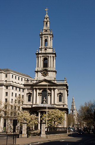
St Mary le Strand is a Church of England church at the eastern end of the Strand in the City of Westminster, London. It lies within the Deanery of Westminster within the Diocese of London. The church stands on what was until recently a traffic island to the north of Somerset House, King's College London's Strand campus, and south of Bush House. It is the official church of the Women's Royal Naval Service, and has a book of remembrance for members who have died in service. The nearest tube station is Temple, with the now-closed Aldwych station nearly opposite the church. It is known as one of the two 'Island Churches', the other being St Clement Danes.

St Andrew Undershaft is a Church of England church in the City of London, the historic nucleus and modern financial centre of London. It is located on St Mary Axe, within the Aldgate ward, and is a rare example of a City church that survived both the Great Fire of London and the Blitz.

The Kit-Cat Club was an early 18th-century English club in London with strong political and literary associations. Members of the club were committed Whigs. They met at the Trumpet tavern in London and at Water Oakley in the Berkshire countryside.

Northumberland House was a large Jacobean townhouse in London, so-called because it was, for most of its history, the London residence of the Percy family, who were the Earls and later Dukes of Northumberland and one of England's richest and most prominent aristocratic dynasties for many centuries. It stood at the far western end of the Strand from around 1605 until it was demolished in 1874. In its later years it overlooked Trafalgar Square.

St Mary Aldermanbury was a parish church in the City of London first mentioned in 1181 and destroyed by the Great Fire of London in 1666. Rebuilt in Portland stone by Christopher Wren, it was again gutted by the Blitz in 1940, leaving only the walls standing. These stones were transported to Fulton, Missouri in 1966, by the residents of that town, and rebuilt in the grounds of Westminster College as a memorial to Winston Churchill. Churchill had made his Sinews of Peace, "Iron Curtain" speech in the Westminster College Gymnasium in 1946.

The Guild Church of St Mary Aldermary, a contraction of St Mary Aldermanbury, is an Anglican church located in Watling Street at the junction with Bow Lane, in the City of London. Of medieval origin, it was rebuilt from 1510 - 1632. Badly damaged in the Great Fire of London in 1666, it was rebuilt once more, this time by Sir Christopher Wren; unlike the vast majority of Wren's City churches, St Mary Aldermary is in the Gothic style.
St Martin's Lane is a street in the City of Westminster, which runs from the church of St Martin-in-the-Fields, after which it is named, near Trafalgar Square northwards to Long Acre. At its northern end, it becomes Monmouth Street. St Martin's Lane and Monmouth Street together form the B404.

Northumberland Avenue is a street in the City of Westminster, Central London, running from Trafalgar Square in the west to the Thames Embankment in the east. The road was built on the site of Northumberland House, the London home of the Percy family, the Dukes of Northumberland between 1874 and 1876, and on part of the parallel Northumberland Street.

St Antholin, Budge Row, or St Antholin, Watling Street, was a church in the City of London. Of medieval origin, it was rebuilt to the designs of Sir Christopher Wren, following its destruction in the Great Fire of London in 1666. The 17th-century building was demolished in 1874.

St Mary Colechurch was a parish church in the City of London destroyed in the Great Fire of London in 1666 and not rebuilt.

St Peter le Poer was a parish church on the west side of Broad Street in the City of London. Of medieval origin, it was rebuilt in 1540, and again in 1792 to a design by Jesse Gibson with a circular nave. It was demolished in 1907.

St Michael-le-Querne, also called St Michael ad Bladum, was a parish church in the Farringdon Within Ward in the City of London. It was destroyed in the Great Fire of London of 1666 and not rebuilt. The name is apparently a reference to a quern-stone as there was a corn market in the churchyard.

St. Leonard, Eastcheap, sometimes referred to as St Leonard Milkchurch, was a parish church in the City of London. Of medieval origin, it was destroyed in the Great Fire of London in 1666 and not rebuilt. The site of the church was retained as a graveyard.

The Cheshire Cheese is a public house at 5 Little Essex Street, London WC2, on the corner with Milford Lane.

South Audley Street is a major shopping street in Mayfair, London. It runs north to south from the southwest corner of Grosvenor Square to Curzon Street.

St Luke's Church in Charlton, London, England, is an Anglican parish church in the Diocese of Southwark.

Trump Street is a street in the City of London that was originally known as Trumpadere Street, probably after the trumpet or horn makers who once worked there or in the adjacent Trump Alley. It was built after the Great Fire of London (1666) but completely destroyed by bombing during the Second World War and has since been entirely rebuilt.
Citations
Sources