
Jacksonville is the most populous city proper in the U.S. state of Florida, located on the Atlantic coast of northeastern Florida. It is the seat of Duval County, with which the City of Jacksonville consolidated in 1968. It is the largest city by area in the contiguous United States as of 2020.
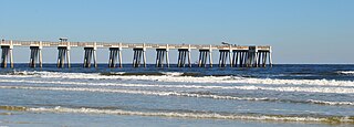
Jacksonville Beach is a coastal resort city in Duval County, Florida, United States. It was incorporated on May 22, 1907, as Pablo Beach, and changed to Jacksonville Beach in 1925. The city is part of group of communities collectively referred to as the Jacksonville Beaches. These communities include Mayport, Atlantic Beach, Neptune Beach, and Ponte Vedra Beach. When the city of Jacksonville consolidated with Duval County in 1968, Jacksonville Beach, together with Atlantic Beach, Neptune Beach, and Baldwin, voted to retain their own municipal governments. As a result, citizens of Jacksonville Beach are also eligible to vote in mayoral election for the City of Jacksonville. As of the 2020 US census, Jacksonville Beach had a total population of 23,830, up from 21,362 at the 2010 census. It is part of the Jacksonville, Florida Metropolitan Statistical Area.

Neptune Beach is a beachfront city east of Jacksonville in Duval County, Florida, United States. When the majority of Duval County communities consolidated with Jacksonville in 1968, Neptune Beach, along with Jacksonville Beach, Atlantic Beach and Baldwin remained quasi-independent. Like those other municipalities, it maintains its own municipal government but its residents vote in the Jacksonville mayoral election and are represented on the Jacksonville city council. As of the 2020 census, the population is 7,217, up from 7,037 at the 2010 census. Neptune Beach is the smallest of the Jacksonville Beaches communities. it is part of the Jacksonville, Florida Metropolitan Statistical Area.
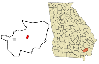
Nahunta is a city and the county seat in Brantley County, Georgia, United States. It is part of the Brunswick, Georgia metropolitan statistical area. The population was 1,013 at the 2020 census. The city is an important crossroad which is intersected by U.S. Route 82 and U.S. Route 301 in its downtown area.

Missouri generally has a variety of seasonal humid subtropical climate, with cool winters and long, hot summers. In the southern part of the state, particularly in the Bootheel, the climate borders on a more mild-type humid subtropical climate, and in the northern third, the state transitions into a humid continental climate. Because of its location in the interior United States, Missouri often experiences extremes in temperatures. Lacking either large mountains or oceans nearby to moderate its temperature, its climate is alternately influenced by air from the cold Arctic and the hot and humid Gulf of Mexico.

USS Charles F. Adams (DD-952/DDG-2), named for Charles Francis Adams III, was the lead ship of her class of guided missile destroyers of the United States Navy. Commissioned in 1960, during her 30-year operational history she participated in the recovery operation for the Mercury 8 space mission, and the Cuban Missile Crisis, as well as operations in the Indian Ocean and Arabian Sea. Decommissioned in 1990, attempts to save her as a museum ship failed and she was scrapped in 2021.
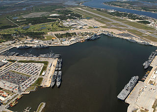
Naval Station Mayport is a major United States Navy base in Jacksonville, Florida. It contains a protected harbor that can accommodate aircraft carrier-size vessels, ship's intermediate maintenance activity (SIMA) and a military airfield with one asphalt paved runway (5/23) measuring 8,001 ft × 200 ft.

Annette Island or Taak'w Aan (Tlingit) is an island in the Gravina Islands of the Alexander Archipelago of the Pacific Ocean on the southeastern coast of the U.S. state of Alaska. It is at 55°08′06″N131°27′21″W. It is about 18 km (11 mi) long and about 18 km (11 mi) wide. The land area is 332.573 km2 (128.407 sq mi). Annette Island is located west across the Revillagigedo Channel from the Alaska mainland and south of Revillagigedo Island. The Island was named in 1879 by William Healey Dall, an American naturalist and explorer in Alaska, in honor of his wife Annette Whitney Dall.
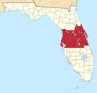
Central Florida is a region of the U.S. state of Florida. Different sources give different definitions for the region, but as its name implies it is usually said to comprise the central part of the state, including the Tampa Bay area and the Greater Orlando area, though in recent times the Tampa Bay area has often been described as its own region, with "central Florida" becoming more synonymous with the Orlando area.

North Stratford is an unincorporated community in the town of Stratford in Coos County, New Hampshire, United States. It is located in the northwestern corner of the town, along the Connecticut River and adjacent to Bloomfield, Vermont.

The climate of California varies widely from hot desert to alpine tundra, depending on latitude, elevation, and proximity to the Pacific Coast. California's coastal regions, the Sierra Nevada foothills, and much of the Central Valley have a Mediterranean climate, with warmer, drier weather in summer and cooler, wetter weather in winter. The influence of the ocean generally moderates temperature extremes, creating warmer winters and substantially cooler summers in coastal areas.
Dalton is an unincorporated census-designated place in the town of Kingston located in the southwestern corner of Green Lake County, Wisconsin, United States. It is located on Wisconsin Highway 44. It uses ZIP code 53926. As of the 2010 census, its population was 206. The surrounding countryside is mainly occupied by dairy farmers and an Amish community. Dalton has an area of 0.456 square miles (1.18 km2); 0.449 square miles (1.16 km2) of this is land, and 0.007 square miles (0.018 km2) is water. Dalton was named for John Dalton, who emigrated from Ireland with his family in the early 1850s.

Blount Island Command is a marine corps support facility located in Jacksonville, Florida.
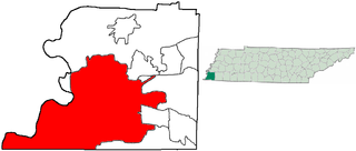
The City of Memphis is located on the eastern bank of the Mississippi River in the southwest corner of the U.S. state of Tennessee. It is the regional hub for a tri-state area of Arkansas, Mississippi and Tennessee.

Much of the state of Florida is situated on a peninsula between the Gulf of Mexico, the Atlantic Ocean, and the Straits of Florida. Spanning two time zones, it extends to the northwest into a panhandle along the northern Gulf of Mexico. It is bordered on the north by the states of Georgia and Alabama, on the west, at the end of the panhandle, by Alabama. It is near The Bahamas, and several Caribbean countries, particularly Cuba. Florida has 131 public airports, and more than 700 private airports, airstrips, heliports, and seaplane bases. Florida is one of the largest states east of the Mississippi River, and only Alaska and Michigan are larger in water area.

Cerro is an unincorporated community in Taos County, New Mexico, United States located along New Mexico State Road 378. It was founded in 1854 by settlers from Taos and Questa and was named for Cerro Guadalupe.

The Charles E. Bennett Memorial Bridge carries Florida State Road 116 traffic over the Intracoastal Waterway south of the St. Johns River in Jacksonville, Florida. It was named for Charles Edward Bennett, a member of the United States House of Representatives from Florida who was involved in the creation of Mayport Naval Station. The bridge is commonly referred to as the Wonderwood Bridge, as the bridge is located on Wonderwood Drive.
Luna is an unincorporated community in southern Marshall County, Minnesota, United States.

According to the Köppen climate classification, the climate of New York City is humid subtropical (Cfa), with parts of the city transitioning into a humid continental climate. (Dfa). The city experiences moderately cold, somewhat wet and snowy winters; and hot, humid summers with plentiful rainfall all year round. Also, New York's enormous population, human activity, and vast amounts of large buildings and streets, which absorb sunlight during the day, contribute significantly to the urban heat island effect. Were it not for this phenomenon, its climate would probably be within the humid continental temperature range.
Massadona is an unincorporated community in Moffat County, in the U.S. state of Colorado.


