Environment
The Mbari River is the main drainage axis of the Mbomou plateau. It is about 450 kilometres (280 mi) long, running in a NE-SW direction through a 2–3 kilometres (1.2–1.9 mi) wide alluvial plain. It drains a catchment area of 23,600 square kilometres (9,100 sq mi). The plateau has an elevation of 500–700 metres (1,600–2,300 ft), slightly inclined to the south, on the Asande rise between the Lake Chad depression to the north and the Congo Basin to the south. A study published in 2002 found signs that forest plants were replacing savanna vegetation in the Mbari valley, in part due to sufficient annual rainfall, reduced frequency of bush fires and migration of rural people away from the region due to the economic crisis in Central Africa.
African wild dogs have been documented in the south of the CAR in the Chinko/Mbari drainage basin in 2013.
History
The Bandia clan separated from the Abaza clan in the early 17th century. They controlled a large area between the Uele River and the Mbomou River. [4] In the last quarter of the 18th century one of their leaders, Ndounga, founded what became the Bangassou kingdom over the Nzakara people on the Mbari river. His brother Kassanga founded what became the Rafai kingdom on the Chinko River. These kingdoms prospered during the 19th century by participating in the growing slave trade, and thus avoiding raids by slave traders. [5]
In the 1880s the chief Bangassou, whom the Belgians called Sultan Bangassou, began to obtain rifles from agents of the Congo Free State, and used these to expand his power. In January he moved his headquarters to where the Mbari enters the Bangassou. [6] [lower-alpha 1] The Belgian Alphonse van Gèle founded the Yakoma post on the Ubangi River on 31 May 1890. Bangassou visited him there on 14 June 1890 and signed a treaty placing his Nzakara kingdom under the protection of the Congo Free State in order to obtain trade goods, weapons and military support from the Europeans. He sold huge quantities of ivory to agents of the Congo Free State. [6] In 1894 the Belgian Léon Hanolet ascended the Bari River while Théodore Nilis and Charles de la Kethulle ascended the Chinko River, another tributary of the Bomu.

The Uele, also known by the phonetically identical Uélé, Ouélé, or Welle River, is a river in the Democratic Republic of the Congo.
The Mbomou River or Bomu forms part of the boundary between the Central African Republic (CAR) and the Democratic Republic of the Congo (DRC).

Ubangi-Shari was a French colony in central Africa, a part of French Equatorial Africa.

Bangassou is a city in the south eastern Central African Republic, lying on the north bank of the Mbomou River. It has a population of 24,447 and is the capital of the Mbomou prefecture. It is known for its wildlife, market, and nearby Bangassou Airport and is linked by ferry to the Democratic Republic of Congo on the south bank. The city is also home to the Roman Catholic Diocese of Bangassou.

The Banda people are an ethnic group of the Central African Republic. They are likewise found in the Democratic Republic of the Congo, Cameroon, and South Sudan. They were severely affected by slave raids of the 19th century and slave trading out of Africa. Under French colonial rule, most converted to Christianity but retained elements of their traditional religious systems and values.
Mongoumba is a town located in the Lobaye Prefecture, Central African Republic. From 1905–1933, Mongoumba was part of Moyen-Congo.
Simon Narcisse Bozanga was a Central African politician. He was Prime Minister of the Central African Republic from 4 April 1981 to 1 September 1981, when his government was overthrown by a military coup.

Pousargues's mongoose, also known as the African tropical savannah mongoose, is a mongoose native to Central Africa. It is listed as data deficient on the IUCN Red List as little is known about its distribution and ecology. It is the only species in the genus Dologale.
Bangassou Airport is an airport serving Bangassou, a city on the Mbomou River in the Mbomou prefecture of the Central African Republic. The Mbomou River forms the local border with the Democratic Republic of the Congo.

Jean Jacques Marie Ferdinand de Béhagle was a French explorer of Africa. He served with the colonial service in Algeria and travelled in the Congo and Ubangi region. While attempting to find a viable land route from the Congo to the Mediterranean via Chad he was taken prisoner by Rabih az-Zubayr and hanged.

Alphonse van Gèle, also written van Gele or Vangele, was a Belgian soldier who served as the Vice-Governor General of the Congo Free State from December 1897 until January 1899. He established the Equator Station, or Station de l’Équateur, today Mbandaka, and concluded a treaty with the powerful Zanzibar trader Tippu Tip at the Stanley Falls station, today Kisangani. He is known for having confirmed that the Uele River was the upper part of the Ubangi River.
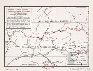
The Central African Republic–Democratic Republic of the Congo border is 1,747 km in length and runs from the tripoint with the Republic of the Congo in the west to the tripoint with South Sudan in the east.
Uele District was a district of the Congo Free State and the Belgian Congo. It roughly corresponded to the current provinces of Bas-Uélé and Haut-Uélé.
The Chinko River is a river of the Central African Republic. It is a right tributary of the Mbomou River.
Jules Alexandre Milz was a Belgian soldier who was active in exploring the northeast of the Congo Free State. He traveled extensively in Uele District, where he resolved the question of whether the Uele River was the upper portion of the Ubangi River. He was second in command of an expedition to the Nile in 1891–1892, and took over command after the leader died.

Léon-Charles-Édouard Hanolet was a Belgian soldier, explorer and colonial administrator. He is known for his explorations in 1894–1895 in what is now the Central African Republic, which led to an agreement between France and Belgium that the Ubangi-Mbomou rivers would form the boundary between their territories. He defended the Lado Enclave against the retreating Mahdist forces in 1898.
Georges-Edouard le Marinel was a Belgian soldier, engineer, explorer and colonial administrator. He is known for leading explorations of the country around the Ubangi River and Mbomou River, which later became the boundaries between French and Belgian territory.

Central African nationality law is regulated by the Constitution of the Central African Republic, as amended; the Central African Republic's Nationality Code, and its revisions; and various international agreements to which the country is a signatory. These laws determine who is, or is eligible to be, a national of the Central African Republic. The legal means to acquire nationality, formal legal membership in a nation, differ from the domestic relationship of rights and obligations between a national and the nation, known as citizenship. Central African nationality is typically obtained under the principle of jus sanguinis, i.e. by birth in the Central African Republic or abroad to parents with Central African nationality. It can be granted to persons with an affiliation to the country, or to a permanent resident who has lived in the country for a given period of time through naturalization.

Sultan Djabir was ruler of a region on the Uele River in what is now the Democratic Republic of the Congo. He engaged in the ivory and slave trade with Muslims from the north and with Belgians from the south. Eventually he was forced to flee to the Sudan when he refused to pay tribute to the Congo Free State.
This page is based on this
Wikipedia article Text is available under the
CC BY-SA 4.0 license; additional terms may apply.
Images, videos and audio are available under their respective licenses.
