McCurtain, Oklahoma

Last updated

McCurtain, Oklahoma
USA Oklahoma location map.svg
Red pog.svg
McCurtain, Oklahoma
Location of McCurtain, Oklahoma
Coordinates: 35°09′03″N94°58′01″W / 35.15083°N 94.96694°W / 35.15083; -94.96694
Country United States
State Oklahoma
County Haskell
Government
  Type Incorporated
Area
[1]
  Total1.13 sq mi (2.92 km2)
  Land1.11 sq mi (2.87 km2)
  Water0.02 sq mi (0.05 km2)
Elevation
[2]
627 ft (191 m)
Population
 (2020)
  Total355
  Density320.69/sq mi (123.80/km2)
Time zone UTC-6 (Central (CST))
  Summer (DST) UTC-5 (CDT)
ZIP code
74944
Area code(s) 539/918
FIPS code 40-44950 [3]
GNIS feature ID2412967 [2]

McCurtain is a town in Haskell County, Oklahoma, United States. The population was 357 at the 2020 census, a 30.8% decrease over the figure of 516 recorded in 2010. [4] A coal mine disaster in 1912 killed 73 miners and ended McCurtain's prosperity. The mine explosion remains one of the worst disasters in Oklahoma history.

Contents

History

In 1889, coal deposits discovered in the area that would become southern Haskell County attracted some European miners and American entrepreneurs. They established a community called Panther, which was renamed in 1902 to honor Choctaw Principal Chief Green McCurtain. Another mining town, Chant, was established nearby, and the two began to grow together. McCurtain and Chant prospered after the Fort Smith and Western Railroad connected McCurtain with Fort Smith, Arkansas in 1901. The railroad was built westward until it reached the Canadian River in 1902. The San Bois Coal Company built four hundred company houses for miners living in McCurtain and Chant. By 1907 statehood the combined population of the two communities was 1,760. [5]

A post office was established at Panther, Indian Territory on June 11, 1890. Its name was changed to McCurtain, Indian Territory on April 5, 1902. The site was located one half-mile west of its present site. At the time of its founding, the community was located in the Moshulatubbee District of the Choctaw Nation. [6]

In 1901 the two towns thrived as the Fort Smith and Western Railroad built to McCurtain, connecting it with Fort Smith, Arkansas. In 1902 the railroad continued building westward, reaching the South (main) Canadian River. The San Bois Coal Company built four hundred company houses, and McCurtain, as well as Chant, saw the addition of banks, stores, schools, newspapers, and even a bottling company. By 1907 statehood the combined population of the communities stood at 1,760, although in 1908 business directories suggested a combined population of 3,800, which would have been the largest to be seen in Haskell County. Newspapers that have served the two communities included the Haskell County Chant News, the Hustler, McCurtain American, McCurtain Leader, and Sans Bois News.

The towns and all of their successes, however, could not withstand the events of March 20, 1912, when a terrific underground explosion in Mine Number Two took the lives of seventy-three miners and sent the San Bois Coal Company into bankruptcy. With mining all but played out, the town's combined population dropped to 1,341 in 1920. The communities officially consolidated in 1922, but the Chant post office had closed in 1910. In 1940 the population rested at 870, declining to 528 by 1960. By 2000 the last of the mines had all closed. The town's population had dwindled to 466, a downward trend that reversed; in 2010 the number stood at 516. The only reminder of McCurtain's once-prosperous past was a memorial standing silently at the site of old Mine Number Two and seventy-three graves in the nearby Miners Cemetery. According to the Encyclopedia of Oklahoma History and Culture, "The only reminder McCurtain had to show of its once prosperous past was a memorial standing silently at the site of old Mine Number Two and seventy-three graves in the nearby Miners Cemetery." [5]

Economic Development

McCurtain's rapid economic transformation began with the discovery of coal in 1889, the same year as the Land Run. This discovery attracted a diverse influx of people, including Eastern European miners and American entrepreneurs, fueling the town's growth. At the forefront of this mining boom was the Sans Bois Mining Company, or Sans Bois Coal Company. In 1901, industrialist Henry Clay Frick, determined to source coal in his steel operations, purchased the Sans Bois Coal Company through ownership of the Fort Smith and Western Railway. [7]

The town of McCurtain faced successive decades of economic decline following the tragic explosion at San Bois Coal Company’s Mine Number Two. The 1912 tragedy would claim the lives of 73 miners and would begin a series of decades that included substantial population decline, decreases in job opportunities in the area, economically depressed residents would grow accustomed to severe poverty and even the next several generations that remained in the area live at or below the poverty level. [8]

Geography

McCurtain is 57 miles (92 km) east of McAlester and 28 miles (45 km) south southwest of Sallisaw. [5]

According to the United States Census Bureau, the town has a total area of 1.1 square miles (2.8 km2), of which 1.1 square miles (2.8 km2) is land and 0.04 square miles (0.10 km2) (1.77%) is water.

Historical population
CensusPop.Note
1910 526
1920 1,062101.9%
1930 934−12.1%
1940 870−6.9%
1950 705−19.0%
1960 528−25.1%
1970 5758.9%
1980 549−4.5%
1990 465−15.3%
2000 4660.2%
2010 51610.7%
2020 355−31.2%
U.S. Decennial Census [9]

Demographics

As of the census [3] of 2000, there were 466 people, 178 households, and 122 families residing in the town. The population density was 420.5 inhabitants per square mile (162.4/km2). There were 213 housing units at an average density of 192.2 per square mile (74.2/km2). The racial makeup of the town was 75.54% White, 16.74% Native American, 1.29% Asian, and 6.44% from two or more races. Hispanic or Latino of any race were 1.29% of the population.

There were 178 households, out of which 36.0% had children under the age of 18 living with them, 54.5% were married couples living together, 11.8% had a female householder with no husband present, and 30.9% were non-families. 29.8% of all households were made up of individuals, and 17.4% had someone living alone who was 65 years of age or older. The average household size was 2.62 and the average family size was 3.28.

In the town, the population was spread out, with 30.5% under the age of 18, 9.2% from 18 to 24, 24.2% from 25 to 44, 21.7% from 45 to 64, and 14.4% who were 65 years of age or older. The median age was 34 years. For every 100 females, there were 95.8 males. For every 100 females age 18 and over, there were 97.6 males.

The median income for a household in the town was $22,188, and the median income for a family was $29,167. Males had a median income of $29,167 versus $15,833 for females. The per capita income for the town was $11,410. About 16.2% of families and 22.5% of the population were below the poverty line, including 28.2% of those under age 18 and 25.0% of those age 65 or over.

Related Research Articles

<span class="mw-page-title-main">Pittsburg County, Oklahoma</span> County in Oklahoma, United States

Pittsburg County is a county located in the U.S. state of Oklahoma. As of the 2020 census, the population was 43,773. Its county seat is McAlester. The county was formed from part of the Choctaw Nation in Indian Territory in 1907. County leaders believed that its coal production compared favorably with Pittsburgh, Pennsylvania at the time of statehood.

<span class="mw-page-title-main">LeFlore County, Oklahoma</span> County in Oklahoma, United States

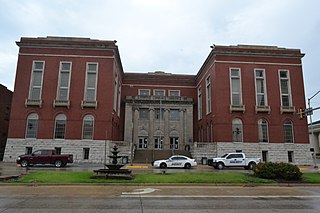
LeFlore County is a county along the eastern border of the U.S state of Oklahoma. As of the 2020 census, the population was 48,129. Its county seat is Poteau. The county is part of the Fort Smith metropolitan area and the name honors a Choctaw family named LeFlore. The United States District Court for the Eastern District of Oklahoma is the federal district court with jurisdiction in LeFlore County.

<span class="mw-page-title-main">Latimer County, Oklahoma</span> County in Oklahoma, United States

Latimer County is a county located in the southeastern part of the U.S. state of Oklahoma. Its county seat is Wilburton. As of the 2020 census, the population was 9,444. The county was created at statehood in 1907 and named for James L. Latimer, a delegate from Wilburton to the 1906 state Constitutional Convention. Prior to statehood, it had been for several decades part of Gaines County, Sugar Loaf County, and Wade County in the Choctaw Nation.

<span class="mw-page-title-main">Haskell County, Oklahoma</span> County in Oklahoma, United States

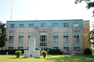
Haskell County is a county located in the southeast quadrant of the U.S. state of Oklahoma. As of the 2020 census, the population was 11,561. Its county seat is Stigler. The county is named in honor of Charles N. Haskell, the first governor of Oklahoma.

<span class="mw-page-title-main">Bonanza, Arkansas</span> City in Arkansas, United States

Bonanza is a city in Sebastian County, Arkansas, United States. It is part of the Fort Smith, Arkansas-Oklahoma Metropolitan Statistical Area. At the 2010 Census, the population of Bonanza was 575. According to the 2018 US Census Bureau estimates, the population of Bonanza was 564. Bonanza began as a coal mining town of the Central Coal and Coke company.

<span class="mw-page-title-main">Hartford, Arkansas</span> City in Arkansas, United States

Hartford is a city in Sebastian County, Arkansas, United States. It is part of the Fort Smith, Arkansas-Oklahoma Metropolitan Statistical Area. The population was 642 at the 2010 census.

<span class="mw-page-title-main">Coalville, Iowa</span> CDP in Iowa, United States

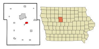
Coalville is a census-designated place (CDP) in Webster County, Iowa, United States. The population was 610 at the 2010 census. The community is located on U.S. Route 20 near Fort Dodge's large gypsum mines.

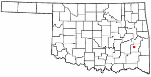
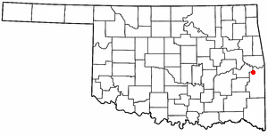
Keota is a town in southeastern Haskell County, Oklahoma, United States. The population was 438 at the 2020 census, a 22.3 percent decrease over the figure of 564 recorded in 2010.

Kinta is a town in Haskell County, Oklahoma, United States. The population was 297 at the 2010 census, an increase of 22.2 percent over the figure of 243 recorded in 2000.

<span class="mw-page-title-main">Stigler, Oklahoma</span> City in Oklahoma, United States

Stigler is a city in and county seat of Haskell County, Oklahoma. The population was 2,685 at the time of the 2010 census, down from 2,731 recorded in 2000.

<span class="mw-page-title-main">Wilburton, Oklahoma</span> City in Oklahoma, United States

Wilburton is a city in Latimer County, Oklahoma, United States. It is the county seat of Latimer County. The city had a population of 2,285 as of the 2020 Census. Robbers Cave State Park is 5 miles (8.0 km) north of Wilburton.

<span class="mw-page-title-main">Bokoshe, Oklahoma</span> Town in Oklahoma, United States

Bokoshe is a town in Le Flore County, Oklahoma, United States. It is part of the Fort Smith, Arkansas-Oklahoma metropolitan statistical area. Bokoshe is a Choctaw word meaning "little creek". The population was 396 at the 2020 census, a 22.3% decrease over the figure of 510 recorded in 2010.

<span class="mw-page-title-main">Panama, Oklahoma</span> Town in Oklahoma, United States

Panama is a town in Le Flore County, Oklahoma, United States. It is part of the Fort Smith, Arkansas-Oklahoma Metropolitan Statistical Area. The population was 1,413 at the 2010 census.

<span class="mw-page-title-main">Pocola, Oklahoma</span> Town in Oklahoma, United States

Pocola is a town in Le Flore County, Oklahoma, United States. It is part of the Fort Smith, Arkansas-Oklahoma metropolitan area. The population was 4,056 in 2010, a gain of 1.6 percent over the figure of 3,994 recorded in 2000. Pocola is a Choctaw word meaning "ten", the approximate distance in miles from Fort Smith, Arkansas.

<span class="mw-page-title-main">Weleetka, Oklahoma</span> Town in Oklahoma, United States

Weleetka is a town in Okfuskee County, Oklahoma, United States. It is approximately 10 miles (16 km) southeast of Okemah, the county seat. The name is a Creek word meaning "running water." The population was 806 at the time of the 2020 census.

<span class="mw-page-title-main">Haileyville, Oklahoma</span> City in Oklahoma, United States

Haileyville is a city in Pittsburg County, Oklahoma, United States. The population was 716 at the time of the 2020 United States census.

<span class="mw-page-title-main">Krebs, Oklahoma</span> City in Oklahoma, United States

Krebs is a city in Pittsburg County, Oklahoma, United States. The population was 2,083 at the time of the 2020 United States census, up 1.5% from the 2,053 reported at the 2010 census, which in turn was a slight increase from the 2,051 reported in 2000. Its nickname is "Little Italy." Krebs was founded before Oklahoma statehood as a coal-mining town in the Choctaw Nation of Indian Territory.

<span class="mw-page-title-main">Savanna, Oklahoma</span> Town in Oklahoma, United States

Savanna is a town in Pittsburg County, Oklahoma, United States. The population was 686 at the 2010 census, a decline of 6.0 percent from the figure of 730 recorded in 2000. It is the hometown of former Harlem Globetrotter and 2014 NAIA Dunk Champion Tyler Inman.

<span class="mw-page-title-main">Ravensdale, Washington</span> Census-designated place in Washington, United States

Ravensdale is a census-designated place (CDP) in King County, Washington, United States. The population was 555 at the 2020 census.

<span class="mw-page-title-main">Carbonado, Washington</span> Town in Washington, United States

Carbonado is a town in Pierce County, Washington, United States. It is located near the Carbon River in the north of the county, approximately 50 miles (80 km) southeast of Seattle. Carbonado is the last town before entering Mount Rainier National Park and is also a popular spot for off-roading. The town also served as an important coal mining community in the late nineteenth and early twentieth centuries, when the town operated the largest coal mine in Pierce County. The population was 734 at the 2020 census.

References

  1. "ArcGIS REST Services Directory". United States Census Bureau. Retrieved September 20, 2022.
  2. 1 2 U.S. Geological Survey Geographic Names Information System: McCurtain, Oklahoma
  3. 1 2 "U.S. Census website". United States Census Bureau . Retrieved January 31, 2008.
  4. CensusViewer:McCurtain, Oklahoma Population. Retrieved February 15, 2014.
  5. 1 2 3 Hyder, Glenn O. Encyclopedia of Oklahoma History and Culture. "McCurtain." Retrieved February 11, 2020.
  6. Morris, John W. Historical Atlas of Oklahoma (Norman: University of Oklahoma Press, 1986), plate 38; Shirk, George H. Oklahoma Place Names (Norman: University of Oklahoma Press, 1965), pp. 132 & 160.
  7. Augustus J. Veenendaal, Jr., Encyclopedia of Oklahoma History and Culture. "Fort Smith and Western Railway." Retrieved March 3, 2024.
  8. United States Census Bureau 2020 U.S. Census (census bureau economic conditions.
  9. "Census of Population and Housing". Census.gov. Retrieved June 4, 2015.