McLain, Mississippi

Last updated
McLain, Mississippi
Greene County Mississippi Incorporated and Unincorporated areas McLain Highlighted.svg
Location of McLain, Mississippi
Usa edcp location map.svg
Red pog.svg
McLain, Mississippi
Location in the United States
Coordinates: 31°6′18″N88°49′26″W / 31.10500°N 88.82389°W / 31.10500; -88.82389 Coordinates: 31°6′18″N88°49′26″W / 31.10500°N 88.82389°W / 31.10500; -88.82389
Country United States
State Mississippi
County Greene
Government
  MayorSteve McCluskey (L) [1]
Area
[2]
  Total3.45 sq mi (8.95 km2)
  Land3.39 sq mi (8.78 km2)
  Water0.06 sq mi (0.16 km2)
Elevation
72 ft (22 m)
Population
 (2020)
  Total313
  Density92.30/sq mi (35.63/km2)
Time zone UTC-6 (Central (CST))
  Summer (DST) UTC-5 (CDT)
ZIP code
39456
Area code 601
FIPS code 28-43840
GNIS feature ID0693928

McLain is a town in Greene County, Mississippi, United States. The population was 441 at the 2010 census, [3] down from 603 at the 2000 census.

Contents

History

Natural disasters

In early spring 2016, McLain had major flooding which closed many roads and the school. [4] On March 30, 2022, an EF2 tornado struck the town, causing considerable damage. [5]

Geography

McLain is located in southwestern Greene County; the western border of the town follows the Perry County line. The town is on the western side of the valley of the Leaf River, a south-flowing tributary of the Pascagoula River.

U.S. Route 98 passes through the northern part of the town; the four-lane highway leads northwest 33 miles (53 km) to Hattiesburg and southeast 60 miles (97 km) to Mobile, Alabama. Mississippi Highway 57 passes through the east side of McLain, leading south 54 miles (87 km) to U.S. Route 90 near Gautier and east 17 miles (27 km) to Leakesville, the Greene County seat.

According to the United States Census Bureau, McLain has a total area of 3.4 square miles (8.9 km2), of which 3.4 square miles (8.8 km2) is land and 0.077 square miles (0.2 km2), or 1.82%, is water, [3] consisting largely of the Leaf River, which flows along part of the eastern edge of the town.

Climate

The climate in this area is characterized by relatively high temperatures and evenly distributed precipitation throughout the year. According to the Köppen Climate Classification system, McLain has a Humid subtropical climate, abbreviated "Cfa" on climate maps.

Demographics

Historical population
CensusPop.Note
1970 632
1980 6888.9%
1990 536−22.1%
2000 60312.5%
2010 441−26.9%
2020 313−29.0%
U.S. Decennial Census [6]
McLain Attendance Center McLain Attendance Center MS.jpg
McLain Attendance Center
McLain High School McLain High School MS.jpg
McLain High School

As of the 2010 United States Census, There were 441 people living in the town. 73.0% were White, 26.1% African American, 0.5% Native American, and 0.5% of two or more races. 0.7% were Hispanic or Latino of any race.

As of the census [7] of 2000, there were 603 people, 228 households, and 157 families living in the town. The population density was 177.7 inhabitants per square mile (68.6/km2). There were 277 housing units at an average density of 81.6 per square mile (31.5/km2). The racial makeup of the town was 63.68% White, 35.66% African American, 0.17% Native American, 0.17% Asian, and 0.33% from two or more races. Hispanic or Latino of any race were 1.33% of the population.

There were 228 households, out of which 40.8% had children under the age of 18 living with them, 40.4% were married couples living together, 22.8% had a female householder with no husband present, and 31.1% were non-families. 28.1% of all households were made up of individuals, and 10.5% had someone living alone who was 65 years of age or older. The average household size was 2.64 and the average family size was 3.27.

In the town, the population was spread out, with 35.8% under the age of 18, 8.0% from 18 to 24, 28.2% from 25 to 44, 18.4% from 45 to 64, and 9.6% who were 65 years of age or older. The median age was 30 years. For every 100 females, there were 84.4 males. For every 100 females age 18 and over, there were 76.7 males.

The median income for a household in the town was $20,000, and the median income for a family was $27,981. Males had a median income of $29,375 versus $14,375 for females. The per capita income for the town was $10,272. About 26.4% of families and 31.2% of the population were below the poverty line, including 40.2% of those under age 18 and 28.6% of those age 65 or over.

Government

The mayor of McLain, Steve McCluskey, is Mississippi's first elected member of the Libertarian Party of Mississippi. [1]

Education

McLain is served by the Greene County School District and the Mclain Attendance Center.

Infrastructure

McLain has a public library run by local citizens. [8] There is also a volunteer fire department. [9]

Notable people

Related Research Articles

<span class="mw-page-title-main">Greene County, Mississippi</span> County in Mississippi, United States

Greene County is a county located on the southeast border of the U.S. state of Mississippi. As of the 2020 census, the population was 13,530. Its county seat is Leakesville. Established in 1811, the county was named for General Nathanael Greene of the American Revolutionary War.

<span class="mw-page-title-main">Eutaw, Alabama</span> City in and county seat of Greene County, Alabama

Eutaw is a city in and the county seat of Greene County, Alabama, United States. At the 2020 census, the population was 2,937. The city was named in honor of the Battle of Eutaw Springs, the last engagement of the American Revolutionary War in the Carolinas.

<span class="mw-page-title-main">Newberry, Indiana</span> Town in Indiana, United States

Newberry is a town in Cass Township, Greene County, Indiana, United States. The population was 193 at the 2010 census. It is part of the Bloomington, Indiana Metropolitan Statistical Area.

<span class="mw-page-title-main">Switz City, Indiana</span> Town in Indiana, United States

Switz City is a town in Fairplay and Grant townships, Greene County, Indiana, United States. The population was 293 at the 2010 census. It is part of the Bloomington, Indiana, Metropolitan Statistical Area.

<span class="mw-page-title-main">Ashland, Mississippi</span> Town in Mississippi, United States

Ashland is a town in Benton County, Mississippi, United States and the county seat. The population was 569 at the 2010 census. Ashland was incorporated on March 8, 1871, and has a Mayor-Aldermen form of government. Mitch Carroll is the 28th mayor of Ashland.

<span class="mw-page-title-main">Hickory Flat, Mississippi</span> Town in Mississippi, United States

Hickory Flat is a town in Benton County, Mississippi, United States. The population was 601 at the 2010 census.

<span class="mw-page-title-main">Carrollton, Mississippi</span> Town in Mississippi, United States

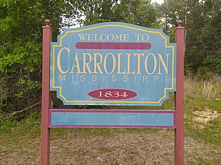
Carrollton is a town in and the second county seat of Carroll County, Mississippi, United States, which is within the Mississippi Delta. The population was 190 at the 2010 census, down from 408 in 2000. Centrally located in the county, the town is part of the Greenwood, Mississippi micropolitan area. The first county seat, Vaiden, Mississippi, was founded in the eastern part of the county during its early settlement.

<span class="mw-page-title-main">Lucedale, Mississippi</span> City in Mississippi, United States

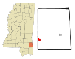
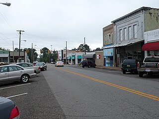
Lucedale is a city in George County, Mississippi, United States. It is part of the Pascagoula, Mississippi Metropolitan Statistical Area. Lucedale was founded in 1901 when Governor A.H. Longino signed his name and his seal to the proclamation. It was named after its founder, Gregory Marston Luce, who operated a lumber business there. The population was 2,923 at the 2010 census, up from 2,458 at the 2000 census. It is the county seat of George County.

<span class="mw-page-title-main">Leakesville, Mississippi</span> Town in Mississippi, United States

Leakesville is a town in and the county seat of Greene County, Mississippi, United States. It is located along the Chickasawhay River in Greene County, Mississippi, United States. It is served by the junction of Mississippi routes 57 and 63. As of the 2010 census, the rural town population was 898, down from 1,026 at the 2000 census.

<span class="mw-page-title-main">Bolton, Mississippi</span> Town in Mississippi, United States

Bolton is a town in Hinds County, Mississippi, United States. The population was 567 at the 2010 census, down from 629 at the 2000 census. It is part of the Jackson Metropolitan Statistical Area.

<span class="mw-page-title-main">Edwards, Mississippi</span> Town in Mississippi, United States

Edwards is a town in Hinds County, Mississippi, United States. The population was 1,034 at the 2010 census, down from 1,347 at the 2000 census. It is part of the Jackson Metropolitan Statistical Area.

<span class="mw-page-title-main">Learned, Mississippi</span> Town in Mississippi, United States

Learned is a town in Hinds County, Mississippi, United States.

<span class="mw-page-title-main">Montrose, Mississippi</span> Town in Mississippi, United States

Montrose is a town in Jasper County, Mississippi, United States. The population was 140 at the 2010 census.

<span class="mw-page-title-main">Marion, Mississippi</span> Town in Mississippi, United States

Marion is a town in Lauderdale County, Mississippi, United States. It is a northeastern suburb of Meridian, the county seat. The population of Marion was 1,479 at the 2010 census.

<span class="mw-page-title-main">Beaumont, Mississippi</span> Town in Mississippi, United States

Beaumont is a town in Perry County, Mississippi. It is part of the Hattiesburg, Mississippi Metropolitan Statistical Area. The population was 951 at the 2010 census.

<span class="mw-page-title-main">Magnolia, Mississippi</span> City in Mississippi, United States

Magnolia is a city in Pike County, Mississippi, United States. The population was 2,420 at the 2010 census. It is the county seat of Pike County, which lies within the McComb, Mississippi Micropolitan Statistical Area.

<span class="mw-page-title-main">Metcalfe, Mississippi</span> Town in Mississippi, United States

Metcalfe is a town in Washington County, Mississippi, United States. The population was 1,067 at the 2010 census. The county is located on the western border of the state, with the Mississippi River on the west. It is within the Mississippi Delta.

<span class="mw-page-title-main">Iaeger, West Virginia</span> Town in West Virginia, United States

Iaeger is a town in McDowell County, West Virginia, United States. The population was 257 at the 2020 census.

<span class="mw-page-title-main">Mathiston, Mississippi</span> Town in Mississippi, United States

Mathiston is a town in Choctaw and Webster counties, Mississippi. The population was 698 at the 2010 census.

<span class="mw-page-title-main">State Line, Mississippi</span> Town in Mississippi, United States

State Line is a town in Greene and Wayne counties, Mississippi, in the United States. The population was 452 at the 2020 census.

References

  1. 1 2 "Lounging with Libertarians". St. Louis Post-Dispatch. July 10, 2017.
  2. "2020 U.S. Gazetteer Files". United States Census Bureau. Retrieved July 24, 2022.
  3. 1 2 "Geographic Identifiers: 2010 Demographic Profile Data (G001): McLain town, Mississippi". American Factfinder. U.S. Census Bureau. Retrieved December 20, 2016.[ dead link ]
  4. Vagell, Quincy (March 18, 2016). "Over 26 Inches of Rain Triggers Record Flooding in the South, Including the Sabine River". Weather. Retrieved November 28, 2016.
  5. NWS Damage Survey for 03/30/2022 Greene County, MS and Mobile County, AL Tornado Event (Report). Iowa Environmental Mesonet. National Weather Service in Mobile, Alabama. March 31, 2022. Retrieved March 31, 2022.
  6. "Census of Population and Housing". Census.gov. Retrieved June 4, 2015.
  7. "U.S. Census website". United States Census Bureau . Retrieved 2008-01-31.
  8. "McLain Public Library". Pine Forest Regional Public Library System. Retrieved December 3, 2016.
  9. U.S. Geological Survey Geographic Names Information System: McLain Volunteer Fire Department
  10. "Nathaniel Bolton Stats". ProFootball Archives. Retrieved 25 January 2021.
  11. "Bolton-Holifield, Ruthie 1967–". Encyclopedia.com. Retrieved December 3, 2016.
  12. "De'Lance Turner". Alcorn State University Athletics. Retrieved 25 January 2021.