McMillan, Michigan

Last updated

McMillan, Michigan
McMillan, Michigan (June 2021).jpg
Looking west along M-28
USA Michigan location map.svg
Red pog.svg
McMillan
Location within the state of Michigan
Usa edcp location map.svg
Red pog.svg
McMillan
Location within the United States
Coordinates: 46°20′20″N85°41′14″W / 46.33889°N 85.68722°W / 46.33889; -85.68722
CountryUnited States
State Michigan
County Luce
Township Columbus
Settled1881
Established1882
Elevation
781 ft (238 m)
Time zone UTC-5 (Eastern (EST))
  Summer (DST) UTC-4 (EDT)
ZIP code(s)
49853
Area code 906
GNIS feature ID631994 [1]

McMillan is an unincorporated community in Luce County in the U.S. state of Michigan. [1] The community is located along M-28 within Columbus Township. As an unincorporated community, McMillan has no legally defined boundaries or population statistics of its own but does have its own post office with the 49853 ZIP Code. [2] [3]

Contents

History

McMillan listed on a 1911 county map Luce County, MI map (1911).jpg
McMillan listed on a 1911 county map

The community of McMillan was first settled in 1881 when the Duluth, South Shore and Atlantic Railway built a line through the area. A rail depot named the McMillan Station opened to serve the area. [4] [5] The station and the new community were named after railway executive and future Michigan senator James McMillan. [6] At the time, the area was part of western Chippewa County until Luce County was created in 1887. [7]

McMillan received a post office on April 21, 1882. The post office has continuously remained in operation and is currently located at 22579 M-28 in the center of the community. [8]

McMillan recorded a population of 40 in 1887. The community benefited from the increased lumber industry, and the railway connected it to many other communities within the Upper Peninsula. In 1910, the community reached a peak population of around 300 and consisted of several general stores, hotels, saloons, sawmill, livery, and the Northern Cooperage & Lumber Company. When the lumber industry declined, the community's population reduced to about 200 by 1927, and many businesses left. [9] In 1919, M-25 was designated as a state highway that ran through McMillan. In 1928, the highway was redesignated as M-28. [10] The railway line remains active and is operated by Canadian National Railway but no longer contains a stop or railway station within McMillan. [11]

The Columbus Township Cemetery, also known as the McMillan Cemetery, is located in the community along County Road 415 just south of M-28. [12]

Lincoln School

Around 1910, the McMillan School was built to serve its residents. The building was constructed in an unusual way, in which there are no windows on the front of the building. These were referred to as "blind walls" that were meant to control lighting in the corner classrooms. [13] The building did not receive electricity until 1925. In 1916, the school merged with the larger Standard School system in order to better serve the rural population. The same year, the building also received a significant addition as the student population grew. Until 1922, the school served students up to the eleventh grade, as twelfth grade students had to complete their education in Newberry. In 1923, the school saw its first graduating class of four students. In 1932, the building was rebranded as the Lincoln School, although budget restraints still caused some students to go to Newberry. [14] The school closed by 1973 and students were consolidated into Tahquamenon Area Schools in Newberry. The building was purchased and turned into a bottling company that filtered water from the nearby Tahquamenon River, although the original structure now remains vacant.

Geography

The community of McMillan is located within southeast Columbus Township in the state's Upper Peninsula about 10 miles (16.1 km) west of the village of Newberry. McMillan sits at an elevation of 781 feet (238 m) above sea level. [1] Some areas surrounding the community are included in the Sault Ste. Marie section of the Lake Superior State Forest.

McMillan is centered along M-28 and County Road 415 (known locally as McMillan Avenue). In addition to Newberry, other nearby communities include Dollarville to the east, Curtis and Helmer to the south, Seney to the west, and the smaller McMillan Corner directly to the south along H-33. [15]

Along with Newberry, McMillan has one of only two current post offices in Luce County. The McMillan post office uses the 49853 ZIP Code. The post office serves a much larger area that includes most of Columbus Township and Lakefield Township, as well as a very small northern portion of Portage Township in Mackinac County to the south and the eastern fringes of Germfask Township in Schoolcraft County to the west. [16] [17] The community is served by Tahquamenon Area Schools in Newberry, which has the largest area of any public school district in the state. [18] [19]

The upper portion of the Tahquamenon River flows just north of the center of the community. The Columbus Township Hall is located in McMillan at 7459 County Road 415. [20]

Media

Related Research Articles

<span class="mw-page-title-main">Luce County, Michigan</span> County in Michigan, United States

Luce County is a county located in the Upper Peninsula in the U.S. state of Michigan. As of the 2020 census, the population was 5,339, making it the second-least populous county in Michigan. The county seat is Newberry, Luce County's only incorporated community. The county was set off and organized in 1887 and named after former Michigan Governor Cyrus G. Luce.

<span class="mw-page-title-main">Whitefish Township, Michigan</span> Civil township in Michigan, United States

Whitefish Township is a civil township of Chippewa County in the U.S. state of Michigan. The population was 474 at the 2020 census.

<span class="mw-page-title-main">Newberry, Michigan</span> Village in Michigan, United States

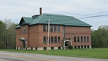
Newberry is a village and county seat of Luce County in the U.S. state of Michigan. The village is located within McMillan Township and is the only incorporated community in Luce County. The population was 1,446 at the 2020 census.

<span class="mw-page-title-main">Newport, Michigan</span> Unincorporated community in Michigan, United States

Newport is an unincorporated community in Monroe County in the U.S. state of Michigan. The community is located within Berlin Charter Township. As an unincorporated community, Newport has no legally defined boundaries or population statistics of its own but does have its own post office with the 48166 ZIP Code.

<span class="mw-page-title-main">Paradise, Michigan</span> Unincorporated community in Michigan, United States

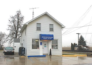
Paradise is an unincorporated community in Whitefish Township, Chippewa County in the U.S. state of Michigan. Paradise is on the northeastern portion of Michigan's Upper Peninsula, on the western side of Whitefish Bay, Lake Superior, about 60 miles (97 km) by road from Sault Ste. Marie and about 55 miles (89 km) north of the Mackinac Bridge. Its zip code is 49768, and the area code is 906. Founded in 1925, Paradise is surrounded by state and national forests and its main business is tourism. It is considered one of two gateways to the Tahquamenon Falls area and Tahquamenon Falls State Park. The area draws hunters, fishers, campers, backpackers, snowmobilers and birdwatchers. The region harvests blueberries and cranberries in season. It is also the home of the blueberry festival held every summer. Lake Superior shipping lanes are several miles off shore. The Paradise post office opened May 1, 1947.

<span class="mw-page-title-main">Pittsford, Michigan</span> Census-designated place & unincorporated community in Michigan, United States

Pittsford is an unincorporated community and census-designated place (CDP) in Hillsdale County in the U.S. state of Michigan. The population of the CDP was 553 at the 2020 census. The community is located along M-34 on the border between Jefferson Township to the west and Pittsford Township to the east.

<span class="mw-page-title-main">M-123 (Michigan highway)</span> State highway in Michigan, United States

M-123 is a state trunkline highway in the eastern Upper Peninsula of the US state of Michigan. It is one of only a few highways in Michigan that curve around and form a U-shape. In fact, M-123 has three intersections with only two state trunklines; it meets M-28 twice as a result of its U-shaped routing. M-123 also has a rare signed concurrency with a County-Designated Highway in Michigan; in Trout Lake, there is a concurrency with H-40. All of M-123 north of M-28 is a Scenic Heritage Route within the Michigan Heritage Route system.

<span class="mw-page-title-main">Gould City, Michigan</span> Unincorporated community in Michigan, United States

Gould City is an unincorporated community in Mackinac County in the U.S. state of Michigan. The community is located within Newton Township. As an unincorporated community, Gould City has no legal autonomy of its own but does have its own post office with the 49838 ZIP Code.

<span class="mw-page-title-main">Curtis, Michigan</span> Unincorporated community in Michigan, United States

Curtis is an unincorporated community in Mackinac County in the U.S. state of Michigan. The community is located within Portage Township. As an unincorporated community, Curtis has no legally defined boundaries or population statistics of its own but does have its own post office with the 49820 ZIP Code.

<span class="mw-page-title-main">Comins, Michigan</span> Unincorporated community in Michigan, United States

Comins is an unincorporated community in Oscoda County in the U.S. state of Michigan. The community is located within Clinton Township. As an unincorporated community, Comins has no legally defined boundaries or population statistics of its own but does have its own post office with the 48619 ZIP Code.

<span class="mw-page-title-main">Helmer, Michigan</span> Unincorporated community in Michigan, United States

Helmer is an unincorporated community in Luce County in the U.S. state of Michigan. The community is located within Lakefield Township. As an unincorporated community, Helmer has no legally defined boundaries or population statistics of its own.

<span class="mw-page-title-main">Ottawa Lake, Michigan</span> Unincorporated community in Michigan, United States

Ottawa Lake is an unincorporated community in Monroe County in the U.S. state of Michigan. The community is located within Whiteford Township. As an unincorporated community, Ottawa Lake has no legally defined boundaries or population statistics of its own but does have its own post office with the 49267 ZIP Code.

<span class="mw-page-title-main">Elmira, Michigan</span> Unincorporated community in Michigan, United States

Elmira is an unincorporated community in the U.S. state of Michigan. Located along M-32, the community is on the county line between Warner Township in Antrim County to the west and Elmira Township in Otsego County to the east.

<span class="mw-page-title-main">Engadine, Michigan</span> Unincorporated community in Michigan, United States

Engadine is an unincorporated community in Mackinac County in the U.S. state of Michigan. The community is located within Garfield Township. As an unincorporated community, Engadine has no legally defined boundaries or population statistics of its own but does have its own post office with the 49827 ZIP Code.

<span class="mw-page-title-main">Garnet, Michigan</span> Unincorporated community in Michigan, United States

Garnet is an unincorporated community in Mackinac County in the U.S. state of Michigan. The community is located within Hudson Township. As an unincorporated community, Garnet has no legally defined boundaries or population statistics of its own.

<span class="mw-page-title-main">Samaria, Michigan</span> Unincorporated community in Michigan, United States

Samaria is an unincorporated community in Monroe County in the U.S. state of Michigan. The community is located within Bedford Township. As an unincorporated community, Samaria has no legally defined boundaries or population statistics of its own but does have its own post office with the 48177 ZIP Code.

<span class="mw-page-title-main">Lake, Clare County, Michigan</span> Unincorporated community in Michigan, United States

Lake is an unincorporated community in Clare County in the U.S. state of Michigan. The community is located within Garfield Township. As an unincorporated community, Lake has no legal autonomy of its own but does have its own post office with the 48632 ZIP Code.

<span class="mw-page-title-main">Columbus Township, Luce County, Michigan</span> Civil township in Michigan, United States

Columbus Township is a civil township of Luce County in the U.S. state of Michigan. As of the 2020 census, the township population was 169.

<span class="mw-page-title-main">McMillan Township, Luce County, Michigan</span> Civil township in Michigan, United States

McMillan Township is a civil township of Luce County in the U.S. state of Michigan. The population was 2,471 at the 2020 census. At 588.78 square miles (1,524.9 km2) of total land area, McMillan Township is the largest municipality by area in the state of Michigan.

<span class="mw-page-title-main">Emerson, Michigan</span> Unincorporated community in Michigan, United States

Emerson is an uninhabited unincorporated community in Chippewa County in the U.S. state of Michigan. As an unincorporated community, Emerson has no legally defined boundaries or population statistics of its own. The community is located within Whitefish Township.

References

  1. 1 2 3 U.S. Geological Survey Geographic Names Information System: McMillan, Michigan
  2. Google (August 24, 2021). "49853 ZIP Code map" (Map). Google Maps . Google. Retrieved August 24, 2021.
  3. UnitedStatesZipCodes.org (2021). "ZIP Code 49853: McMillan" . Retrieved August 24, 2021.
  4. Michiganrailroads.com (2021). "Station: McMillan, MI" . Retrieved October 21, 2021.
  5. U.S. Geological Survey Geographic Names Information System: McMillan Station
  6. Romig, Walter (October 1, 1986) [1973]. Michigan Place Names: The History of the Founding and the Naming of More Than Five Thousand Past and Present Michigan Communities (Paperback). Great Lakes Books Series. Detroit, Michigan: Wayne State University Press. pp. 342–343. ISBN   978-0-8143-1838-6.
  7. "Bibliography on Luce County". Clarke Historical Library, Central Michigan University . Retrieved July 17, 2013.
  8. U.S. Geological Survey Geographic Names Information System: McMillan Post Office
  9. Dodge, Ray (1996) [1973]. Michigan Ghost Towns: Of the Upper Peninsula (formerly Michigan Ghost Towns, Vol. III). Alpena, Michigan: Thunder Bay Press Michigan. pp. 187–188. ISBN   9780934884020.
  10. Michigan State Highway Department (December 1, 1927). Official Highway Service Map (Map). [c. 1:810,000]. Lansing: Michigan State Highway Department. OCLC   12701195, 79754957.
  11. Michigan Department of Transportation (March 2017). "Michigan's Railroad System: Railroads Operating in Michigan" (PDF). Retrieved July 4, 2021.
  12. U.S. Geological Survey Geographic Names Information System: Columbus Township Cemetery
  13. State Historic Preservation Office (September 2003). "An Honor and an Ornament: Public School Buildings in Michigan" (PDF). Retrieved October 22, 2021.
  14. Haynes, Dutch; Delbert, Musgrave; Bohn, Musgrave (2000). History of Columbus Township. McMillan, MI: Columbus Township. pp. 393–395.
  15. U.S. Geological Survey Geographic Names Information System: McMillan Corner, Michigan
  16. Google (September 3, 2021). "49853 ZIP Code map" (Map). Google Maps . Google. Retrieved September 3, 2021.
  17. UnitedStatesZipCodes.org (2021). "ZIP Code 49853: McMillan" . Retrieved September 3, 2021.
  18. Michigan Geographic Framework (November 15, 2013). "Luce County School Districts" (PDF). Retrieved July 24, 2021.
  19. State of Michigan (May 22, 2018). "Square mileage of Michigan school districts" (PDF). Retrieved July 21, 2021.
  20. Michigan Townships Association (2021). "Columbus Twp., Luce Co" . Retrieved October 22, 2021.
  21. Federal Communications Commission (2021). "FM Query Results: WMJT" . Retrieved October 21, 2021.
  22. Theodric Technologies LLC. (2021). "WMJT-FM 96.7 MHz" . Retrieved October 21, 2021.