Related Research Articles

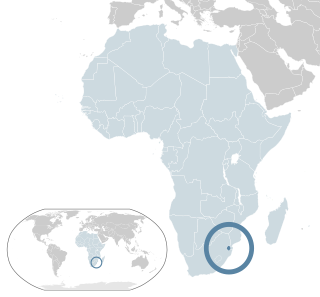
Eswatini, formally the Kingdom of Eswatini and formerly named Swaziland, is a landlocked country in Southern Africa. It is bordered by Mozambique to its northeast and South Africa to its north, west, south, and southeast. At no more than 200 km (120 mi) north to south and 130 km (81 mi) east to west, Eswatini is one of the smallest countries in Africa; despite this, its climate and topography are diverse, ranging from a cool and mountainous highveld to a hot and dry lowveld.
The Umbutfo Eswatini Defence Force (UEDF) is the military of the Southern African Kingdom of Eswatini (Swaziland). It is used primarily during domestic protests, with some border and customs duties; the force has never been involved in a foreign conflict. The army has struggled with high rates of HIV infection. Since measures were put in place the rate is dropping.
Artifacts indicating human activity dating back to the early Stone Age have been found in the Kingdom of Eswatini. The earliest known inhabitants of the region were Khoisan hunter-gatherers. Later, the population became predominantly Nguni during and after the great Bantu migrations. People speaking languages ancestral to the current Sotho and Nguni languages began settling no later than the 11th century. The country now derives its name from a later king named Mswati II. Mswati II was the greatest of the fighting kings of Eswatini, and he greatly extended the area of the country to twice its current size. The people of Eswatini largely belong to a number of clans that can be categorized as Emakhandzambili, Bemdzabu, and Emafikamuva, depending on when and how they settled in Eswatini.

Mbabane is a city in Eswatini, and is one of the two capitals, serving as the executive capital.

Mswati III is Ngwenyama (King) of Eswatini and head of the Swazi royal family.

Hhohho is a region of Eswatini, located in the north western part of the country. Hhohho was named after the capital of King Mswati II, who expanded the Swazi territory to the north and west, taking in the districts of Barberton, Nelspruit, Carolina and Piet Retief. These areas were later acquired by what was the Province of Transvaal and today they form part of the Mpumalanga Province of South Africa. It has an area of 3,625.17 km², a population of 320,651 (2017), and is divided into 14 tinkhundla. The administrative center is the national capital of Mbabane. It borders Lubombo Region on the southeast and Manzini Region in the southwest.

Sobhuza II, was Ngwenyama (King) of Swaziland for 82 years and 254 days, the longest verifiable reign of any monarch in recorded history.
Labotsibeni Mdluli, also known as Gwamile, was the queen mother and queen regent of Swaziland.
Lobamba is a city in Eswatini, and is one of the two capitals, serving as the legislative, traditional, spiritual, seat of government of the Parliament of Eswatini, and Ludzidzini Royal Village, the residence of Queen Ntfombi, the Queen Mother.

Manzini is a large city in Eswatini (Swaziland), which is also the capital of Eswatini's Manzini Region. The city is the country's second largest urban center behind Mbabane, with a population of 110,000 (2008). It is known as "The Hub" of Eswatini and lies on the MR3 road. Eswatini's primary industrial site at Matsapha lies near the town's western border.
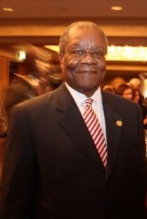
Prince Barnabas Sibusiso Dlamini was a Swazi politician who served as Prime Minister of Eswatini, from 1996 to 2003 and again from October 2008 to September 2018.
The House of Dlamini is the royal house of the Kingdom of Eswatini. Mswati III, as king and Ngwenyama of Eswatini, is the current head of the house of Dlamini. Swazi kings up to the present day are referred to as Ingwenyama and they rule together with the Queen Mother who is called Indlovukati. The Swazi kings, like other Nguni nations, practice polygamy and thus have many wives and children.
Lesbian, gay, bisexual, and transgender (LGBT) rights in Eswatini are limited. LGBT people face legal challenges not experienced by non-LGBT residents. According to Rock of Hope, a Swati LGBT advocacy group, "there is no legislation recognising LGBTIs or protecting the right to a non-heterosexual orientation and gender identity and as a result [LGBT people] cannot be open about their orientation or gender identity for fear of rejection and discrimination". Homosexuality is illegal in Eswatini, though this law is in practice unenforced. According to the 2021 Human Rights Practices Report from the US Department of State, "there has never been an arrest or prosecution for consensual same-sex conduct."
Maxwell Dlamini is the Secretary General of SWAYOCO and the former President of the University of Swaziland Students Representative Council. During the so-called "April 12 Swazi Uprising" in April 2011, he and fellow activist Musa Ngubeni were arrested on charges of possession of explosives under Sections 8 and 9 of Swaziland’s Explosives Act 4 of 1961. They were both allegedly tortured and were subsequently refused bail. They were imprisoned at the Manzini Remand Centre.
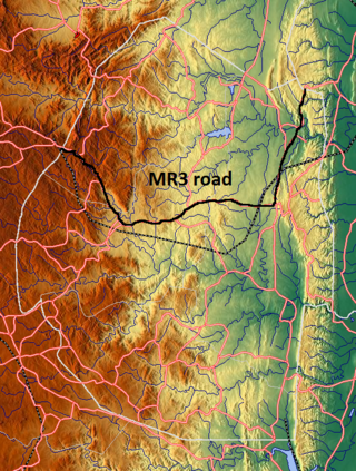
The MR3 road, also known as the Matsapha–Mbabane–Ngwenya road or Road No. MR3, is a major highway of Eswatini. It is one of the most heavily trafficked roads in the country, crossing it from east to west. Along with the MR7 and MR8 roads, it forms the "backbone of Swaziland's internal transport system." It connects the EN5 road in Mozambique near Namaacha at 25°59′21″S31°59′53″E to the N17 road in South Africa at 26°12′45″S30°59′18″E, near Ngwenya. The road passes through Hlane Royal National Park and through the capital of Mbabane, about 110 kilometres (68 mi) further to the southwest. The highway descends into the Ezulwini Valley in four lanes. At Manzini, a bridge crosses the Mzimene River.
Ezulwini Valley is a valley of northwest Eswatini. Also known as "The Valley of Heaven", the valley lasts for about 30 kilometres, and is bounded to the east by the Mdzimba hills. The historical capital of Eswatini Lobamba is located in the valley, also known as the Royal Valley, a place of many legends of Swazi history. The main highway is the MR3 road; some parts have four lanes. The valley extends as far down as Kwaluseni. The valley contains a number of notable wildlife sanctuaries and features including the 4,500-hectare Mlilwane Wildlife Sanctuary and the Royal Swazi Sun Hotel. The valley is undergoing significant development with the growth of Tourism in Eswatini, with the building of casinos, bars, hotels, shops such as the Gables Shopping Centre and urbanization. Also of note is the Ezulwini Handicrafts Centre and Swazi National Museum in Lobamba. Despite the urban developments in the valley, the landscape still has some "soft green hills and plains-game grazing in the lush lands below."

Tatenda Mandaza, known professionally as Tendaness, is a Swazi-born record producer, DJ and songwriter.
Matata is a town in Eswatini.
The history of the Jews of Eswatini, formerly Swaziland.
Eswatini nationality law is regulated by the Constitution of Eswatini, as amended; the Swaziland Citizenship Act, and its revisions; and various international agreements to which the country is a signatory. These laws determine who is, or is eligible to be, a national of Eswatini. The legal means to acquire nationality, formal legal membership in a nation, differ from the domestic relationship of rights and obligations between a national and the nation, known as citizenship. Nationality describes the relationship of an individual to the state under international law, whereas citizenship is the domestic relationship of an individual within the nation. Eswatini nationality is typically obtained under the principle of jus soli, i.e. by birth in Eswatini, or jus sanguinis, born to parents with Eswatini nationality. It can be granted to persons with an affiliation to the country, or to a permanent resident who has lived in the country for a given period of time through naturalisation or the traditional khonta system.
References
- ↑ Westermann, Diedrich; Smith, Edwin William; Forde, Cyril Daryll (1937). Africa. Oxford University Press. Retrieved 22 March 2012.
- ↑ Annual Report on Swaziland. H.M.S.O. 1954. p. 51. Retrieved 22 March 2012.
- ↑ Great Britain. Colonial Office (1895). South Africa: Further correspondence respecting the affairs of Swaziland. Eyre and Spottiswoode. Retrieved 22 March 2012.
| | This Eswatini location article is a stub. You can help Wikipedia by expanding it. |