Meare Lake Village

Last updated
Meare Lake Village
Somerset UK location map.svg
Red pog.svg
Location of Meare Lake Village in Somerset
Location Meare, Somerset, England
Coordinates 51°10′35″N2°47′44″W / 51.17639°N 2.79556°W / 51.17639; -2.79556 Coordinates: 51°10′35″N2°47′44″W / 51.17639°N 2.79556°W / 51.17639; -2.79556
Built Iron Age
Reference no.194185 [1]

Meare Lake Village is the site of an Iron Age settlement on the Somerset Levels at Meare, Somerset, England. It is a Scheduled Ancient Monument. [2] [3]

Contents

Description

In prehistoric times there were two villages situated within the now-drained Meare Pool, occupied at different times between 300 BC and 100 AD, [4] similar to the nearby Glastonbury Lake Village. Investigation of the Meare Pool indicates that it was formed by the encroachment of raised peat bogs around it, particularly during the Subatlantic climatic period (1st millennium BC), and core sampling demonstrates that it is filled with at least 2 metres (6.6 ft) of detritus mud. [5] [6] The pool at that time was at least 2 miles (3.2 km) long by 1 mile (1.6 km) wide. [7]

The villages were built on a morass on an artificial foundation of timber filled with brushwood, bracken, rubble and clay. [8] The two villages, east and west, within Meare Pool appear to originate from a collection of structures erected on the surface of the dried peat, such as tents, windbreaks and animal folds. [9] There were 50 to 60 hut sites in each of the villages. [1]

Clay was later spread over the peat, providing raised stands for occupation, industry and movement, and in some areas thicker clay spreads accommodated hearths built of clay or stone. [9] More recent studies have shown that the villages were formed by laying dried clay over the Sphagnum Moss of the bog. [9]

Little has been found of walls or roofing material, which has led to speculation that the huts were in fact tent-like structures, which may have only been occupied on a seasonal basis. [2]

The lake villages in the area were connected by tracks such as the Sweet Track through the peat bog, and include the Honeygore, Abbotts Way, Bells, Bakers, Westhay, and Nidons trackways. [10] The purpose of these structures was to enable easier travel between the settlements.

Excavation

The Meare villages were discovered in 1895 but excavation did not start until 1908, [11] with much of the early work being carried out by Arthur Bulleid and Harold Gray. [12] [13] In the 1970s the Somerset Levels Project undertook further excavations of the western area and followed this up with exploration of the eastern area in the 1980s. A ground-penetrating radar survey was undertaken in 1998 by the Centre for Wetland Archaeology at the University of Hull when coring was also undertaken by Exeter University. [3]

Archaeologists uncovered several hearths in the buried ruins of one of the houses. They also found several lias stones lying around the fire, including one vertical stone which may have been a backrest. The archaeologists also found several artefacts, including cut pieces of red deer antler, pieces of iron, the rim of a bronze bowl, a spiral finger ring made from bronze, and a decorated amber bead. [14] Bone and antler weaving combs have been found in large numbers suggesting that braid production may have been important. [15]

The site was used during the Iron Age for glass working specialising particularly in bead production, [16] some of which are now in the National Museum of Wales. [17]

Related Research Articles

Glastonbury Human settlement in England

Glastonbury is a town and civil parish in Somerset, England, situated at a dry point on the low-lying Somerset Levels, 23 miles (37 km) south of Bristol. The town, which is in the Mendip district, had a population of 8,932 in the 2011 census. Glastonbury is less than 1 mile (2 km) across the River Brue from Street, which is now larger than Glastonbury.

Somerset Levels Coastal plain and wetland area of Somerset, England

The Somerset Levels are a coastal plain and wetland area of Somerset, England, running south from the Mendips to the Blackdown Hills.

Street, Somerset Human settlement in England

Street is a large village and civil parish in Somerset, England, with a population of 11,805 in 2011. On a dry spot in the Somerset Levels, at the end of the Polden Hills, it is 2 miles (3.2 km) south-west of Glastonbury. There is evidence of Roman occupation. Much of the history of the village is dominated by Glastonbury Abbey, and a 12th-century causeway from Glastonbury built to transport local Blue Lias stone to it.

Sweet Track Ancient causeway in the Somerset Levels, England

The Sweet Track is an ancient trackway, or causeway, in the Somerset Levels, England, named after its finder, Ray Sweet. It was built in 3807 BC and is the second-oldest timber trackway discovered in the British Isles, dating to the Neolithic. It is now known that the Sweet Track was predominantly built along the course of an earlier structure, the Post Track.

River Brue river in Somerset, England

The River Brue originates in the parish of Brewham in Somerset, England, and reaches the sea some 50 kilometres (31 mi) west at Burnham-on-Sea. It originally took a different route from Glastonbury to the sea, but this was changed by Glastonbury Abbey in the twelfth century. The river provides an important drainage route for water from a low-lying area which is prone to flooding which man has tried to manage through rhynes, canals, artificial rivers and sluices for centuries.

Westhay Moor Site of Special Scientific Interest

Westhay Moor is a 513.7-hectare (1,269-acre) biological Site of Special Scientific Interest 2.5 kilometres (1.6 mi) north-east of Westhay village and 4 kilometres (2.5 mi) from Wedmore in Somerset, England, notified in 1971. Westhay Moor is also notified as part of the Somerset Levels and Moors Special Protection Area under the EU Birds Directive and as a Ramsar site, and a National Nature Reserve.

Meare Human settlement in England

Meare is a village and civil parish 3 miles (4.8 km) north west of Glastonbury on the Somerset Levels, in the Mendip district of Somerset, England. The parish includes the village of Westhay.

Peat Moors Centre

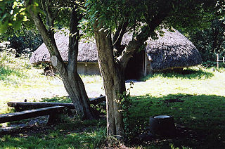
The Peat Moors Centre lay on the road between Shapwick and Westhay in Somerset, England. The centre was run by the Somerset Historic Environment Service, but Somerset County Council closed it in October 2009 in the course of budget cuts.

Glastonbury Lake Village Former Iron Age village in Somerset, UK

Glastonbury Lake Village was an Iron Age village, situated on a crannog or man made island in the Somerset Levels, near Godney, some 3 miles (5 km) north west of Glastonbury in the southwestern English county of Somerset. It has been designated as a scheduled monument.

Meare Pool was a lake in the Somerset Levels in South West England. Lake villages existed there in prehistoric times. During medieval times it was an important fishery, but following extensive drainage works it had disappeared from maps in the eighteenth century.

The Abbots Fish House, Meare Grade I listed building and Scheduled Ancient Monument in Meare, Somerset, England

The Abbot's Fish House in Meare, Somerset, England, was built in the 14th century and has been designated as a Grade I listed building and Scheduled Ancient Monument. It is the only surviving monastic fishery building in England.

The Tribunal, Glastonbury Grade I listed architectural structure in Glastonbury

The Tribunal in Glastonbury, Somerset, England, was built in the 15th century as a merchant's house. It has been designated as a Grade I listed building.

Ham Wall Wetland nature reserve in Somerset, England

Ham Wall is an English wetland National Nature Reserve (NNR) 4 kilometres (2.5 mi) west of Glastonbury on the Somerset Levels. It is managed by the Royal Society for the Protection of Birds (RSPB). Since the last Ice Age, decomposing plants in the marshes of the Brue valley in Somerset have accumulated as deep layers of peat that were commercially exploited on a large scale in the twentieth century. Consumer demand eventually declined, and in 1994 the landowners, Fisons, gave their old workings to what is now Natural England, who passed the management of the 260 hectares Ham Wall section to the RSPB.

Peat extraction on the Somerset Levels

Peat extraction on the Somerset Levels, in South West England has occurred since the area was first drained by the Romans, and continues today on an area of less than 0.5% of the total geography. The modern system in recycling land back to farm use and conservation has resulted in the creation of numerous Sites of Special Scientific Interest.

Scheduled monuments in Mendip

Mendip is a local government district of Somerset in England. The Mendip district covers a largely rural area of 285 square miles (738 km2) ranging from the Mendip Hills through on to the Somerset Levels. It has a population of approximately 110,000. The administrative centre of the district is Shepton Mallet but the largest town is Frome.

Scheduled monuments in Somerset Nationally important sites in Somerset, England

There are over 670 scheduled monuments in the ceremonial county of Somerset in South West England. The county consists of a non-metropolitan county, administered by Somerset County Council, which is divided into five districts, and two unitary authorities. The districts of Somerset are West Somerset, South Somerset, Taunton Deane, Mendip and Sedgemoor. The two administratively independent unitary authorities, which were established on 1 April 1996 following the breakup of the county of Avon, are North Somerset and Bath and North East Somerset. These unitary authorities include areas that were once part of Somerset before the creation of Avon in 1974.

Arthur Bulleid

Arthur Bulleid (1862–1951) was a British antiquarian, known for the excavation of Glastonbury Lake Village and Meare Lake Village.

Harold St George Gray was a British archaeologist. He was involved in the Pitt Rivers Museum in Oxford and later was the librarian-curator of the Museum for the Somerset Archaeological and Natural History Society.

The Avalon Marshes Partnership is a group of conservation organisations working together in the Somerset Levels. The members are Natural England,, the Royal Society for the Protection of Birds (RSPB), the Somerset Wildlife Trust the Hawk and Owl Trust, Historic England, South West Heritage Trust and the Environment Agency. Between 2012 and 2016 the scheme was supported by a Heritage Lottery Fund grant of £1,772,500 with additional investment of £920,080 from other sources. The Avalon Marshes Centre, run by Natural England, is near the Ham Wall reserve. The network of reserves and private land managed for conservation in the Avalon marshes means that wetland management can be carried out on a landscape scale.

References

  1. 1 2 Historic England. "Meare Lake Villages (194185)". Research records (formerly PastScape). Retrieved 24 March 2011.
  2. 1 2 "Iron-age settlement (Meare West), Meare". Somerset Historic Environment Record. Somerset County Council . Retrieved 10 February 2011.
  3. 1 2 "Iron-age settlement (Meare East), Meare". Somerset Historic Environment Record. Somerset County Council . Retrieved 10 February 2011.
  4. "Meare and Ferran Mere". Sacred Sites around Glastonbury. Retrieved 2008-11-03.
  5. Rippon, Stephen (2004). "Making the Most of a Bad Situation? Glastonbury Abbey, Meare, and the Medieval Exploitation of Wetland Resources in the Somerset Levels" (PDF). Medieval Archaeology. Maney Publishing. 48: 119. doi:10.1179/007660904225022816. hdl: 10036/20952 . S2CID   161985196.
  6. Godwin, H.; Macfadyen, W. A. (1955). "Studies of the Post-Glacial History of British Vegetation. XIII. The Meare Pool Region of the Somerset Levels". Philosophical Transactions of the Royal Society B . Royal Society. 239 (662): 161–190. doi: 10.1098/rstb.1955.0008 .
  7. Havinden, Michael (1982). The Somerset Landscape. The making of the English landscape. London: Hodder and Stoughton. pp. 161–162. ISBN   0-340-20116-9.
  8. Cunliffe, Barry (2005). Iron Age Communities in Britain (4th Ed). Abingdon, Oxon: Routledge. p. 266. ISBN   0-415-34779-3.
  9. 1 2 3 Chapmana, Henry P.; Van de Noort, Robert (2001). "High-Resolution Wetland Prospection, using GPS and GIS: Landscape Studies at Sutton Common (South Yorkshire), and Meare Village East (Somerset)". Journal of Archaeological Science. 28 (4): 365–375. doi:10.1006/jasc.2000.0581.
  10. "Sweet Track – Somerset Levels". Digital Digging. Archived from the original on 5 March 2012. Retrieved 8 June 2010.
  11. "The iron-age wetlands of central Somerset" (PDF). Somerset County Council. Archived from the original (PDF) on 4 July 2010. Retrieved 14 November 2010.
  12. "Papers of Dr Arthur Bulleid (1862-1951) of Glastonbury". The National Archives. Retrieved 10 February 2011.
  13. Bulleid, Arthur. "General Description of the Meare Lake Village". Gallica. Archived from the original on 17 February 2012. Retrieved 10 February 2011.
  14. "Meare Lake Village, Somerset". Nature. 142 (3593): 468. September 10, 1938. doi: 10.1038/142468b0 .
  15. Webster, C.J. (2007). The Archaeology of South West England South West Archaeological Research Framework (PDF). Somerset County Council. p. 133. Archived from the original (PDF) on 2016-03-04.
  16. Minnitt, Stephen. "Chapter 12 The iron-age wetlands of central Somerset" (PDF). Somerset County Council. Archived from the original (PDF) on 4 July 2010. Retrieved 10 February 2011.
  17. "Glass Beads". Discovering the Celtic Iron Age in Wales. National Museum of Wales. Archived from the original on 3 October 2012. Retrieved 10 February 2011.