
Randolph County is a county on the central eastern border of the U.S. state of Alabama. As of the 2020 census, the population was 21,967. Its county seat is Wedowee. Its name is in honor of John Randolph, a member of the United States Senate from Virginia. Randolph County was a prohibition or dry county until 2012, when the citizens of Randolph County voted to repeal prohibition.

Randolph County is a county located in the U.S. state of North Carolina. As of the 2020 census, the population was 144,171. Its county seat is Asheboro.

Carroll County is a county in the U.S. state of New Hampshire. As of the 2020 census, the population was 50,107, making it the third-least populous county in New Hampshire. Its county seat is Ossipee. The county was created in 1840 and organized at Ossipee from towns removed from Strafford County. It was named in honor of Charles Carroll of Carrollton, who had died in 1832, the last surviving signer of the United States Declaration of Independence.

Randolph County is a county located in the central section of U.S. state of Indiana, on its eastern border with Ohio. As of 2020, the population was 24,502. The county seat is Winchester.

Randolph County is a county located in the U.S. state of Illinois. According to the 2020 census, it had a population of 30,163. Its county seat is Chester.

Randolph County is a county located in the southwestern portion of the US state of Georgia and is considered part of the Black Belt, historically an area of plantations. As of the 2020 census, the population was 6,425, roughly one-third of its peak population in 1910, when there were numerous agricultural workers. The county seat is Cuthbert.

Jasper County is a county located in the central portion of the U.S. state of Georgia. As of the 2020 census, the population was 14,588, up from 13,900 in 2010. The county seat is Monticello. Jasper County is part of the Atlanta-Sandy Springs-Roswell, GA Metropolitan Statistical Area.

Moreland is a town in Coweta County, Georgia, United States. As of the 2020 census, the town population was 382.
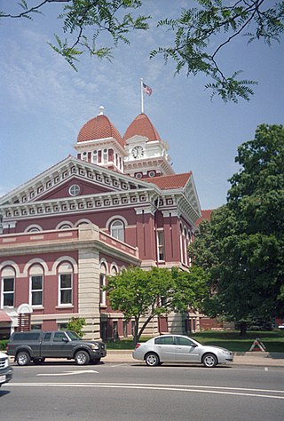
Crown Point is a city in and the county seat of Lake County, Indiana, United States. The population was 33,899 at the 2020 census. The city was incorporated in 1868. On October 31, 1834, Solon Robinson and his family became the first settlers to an area that later became Crown Point. Due to its location, Crown Point is known as the "Hub of Lake County".

Elwood is a city in Madison and Tipton counties in the U.S. state of Indiana. The Madison County portion, which is nearly all of the city, is part of the Indianapolis–Carmel–Anderson metropolitan statistical area. The population of Elwood was 8,410 at the 2020 census.

Lapel is a town in Stony Creek and Green townships, Madison County, Indiana, United States. It is part of the Indianapolis–Carmel–Anderson metropolitan statistical area. The population was 2,325 at the 2020 census, up from 2,068 in 2010.

Modoc is a town in Union Township, Randolph County, in the U.S. state of Indiana. The population was 196 at the 2010 census.

Ridgeville is a town in Franklin Township, Randolph County, Indiana, United States, along the Mississinewa River. The population was 688 at the 2020 census.
Winchester is a city in White River Township, Randolph County, in the U.S. state of Indiana. The population was 4,935 at the 2010 census. The city is the county seat of Randolph County. It is the home of Winchester Speedway.
Shelby Township is a township in Blue Earth County, Minnesota, United States. The population was 294 as of the 2000 census.

Brady Township is a township in Clearfield County, Pennsylvania, United States. The population was 1,942 at the 2020 census.
Randolph is a town in Cattaraugus County, New York, United States. The population was 2,470 at the 2020 census. The town was named after Randolph, Vermont.
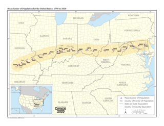
The mean center of the United States population is determined by the United States Census Bureau from the results of each national census. The Bureau defines it as follows:
The concept of the center of population as used by the U.S. Census Bureau is that of a balance point. The center of population is the point at which an imaginary, weightless, rigid, and flat surface representation of the 50 states and the District of Columbia would balance if weights of identical size were placed on it so that each weight represented the location of one person. More specifically, this calculation is called the mean center of population.

In demographics, the center of population of a region is a geographical point that describes a centerpoint of the region's population. There are several ways of defining such a "center point", leading to different geographical locations; these are often confused.

Delaware Township is one of twelve townships in Delaware County, Indiana. According to the 2010 census, its population was 3,481 and it contained 1,591 housing units.
