Medici-Laurentian Atlas

Last updated

World map from the Medici-Laurentian atlas, 1351. Medici-Laurentian Atlas 1351.jpg
World map from the Medici-Laurentian atlas, 1351.

The Medici-Laurentian Atlas, also known simply as the Medici Atlas (and other variants, e.g. "Laurenziano Gaddiano", "Laurentian Portolano", "Atlante Mediceo" or "Laurentian Atlas"), is an anonymous 14th-century set of maps, probably composed by a Genoese cartographer and explicitly dated 1351, although most historians believe it was composed, or at least retouched, later. The atlas is currently held by the Biblioteca Medicea Laurenziana in Florence, Italy.

Contents

Background

The author of the Medici-Laurentian atlas is unknown, save that he comes from the Liguria region of Italy (probably Genoese), and might have composed it for a Florentine owner. The atlas is explicitly dated 1351 (as per its astronomical calendar), but scholars believed it was more likely composed around 1370, possibly from earlier material, and probably amended further later, with emendations as late as 1425–50. [1] [2]

A 1370 date would place it in between the Pizzigani brothers map of 1367 and the Catalan Atlas of 1375, both of which share elements of the Medici-Laurentian map, although it is impossible to tell exactly if it preceded or followed them. [3] It is also contemporaneous with the Libro del Conoscimiento , a fantastical travelogue by an unknown Castilian author, believed to have been written sometime between 1350 and 1399, with which it shares many significant geographic features. The book's author may have inspired, or have been inspired by, the Medici-Laurentian atlas. [4]

The Atlas is currently held by the Biblioteca Medicea Laurenziana in Florence, Italy (Gaddi. Rel. 9).

Features

The Medici-Laurentian atlas is composed of eight sheets. The first sheet is an astronomical calendar, the second sheet contains an unusual world map , the third, fourth and fifth sheets compose a typical 14th-century portolan chart (covering Europe, North Africa, the Mediterranean and Black Seas), the sixth, seventh and eighth sheets are specialized charts of the Aegean Sea, Adriatic Sea and Caspian Sea. [2]

World map

The second sheet, the world map, is the one that has attracted most attention. If the original date 1351 is true, that would make it the first (extant) map to incorporate the travel reports of Marco Polo and Ibn Batuta. It shows Asia up to India, marking places like the Delhi Sultanate and others with reasonable accuracy. The atlas also shows the Caspian as a closed sea (unusual for maps of that time).

Among the most startling features is its depiction of the recognizable shape of the continent of Africa with remarkable precision. Nearly a century before the Portuguese Age of Discovery, the Medici atlas draws the bend of the Gulf of Guinea and shows that Africa has a southern end, i.e. that the Atlantic and Indian Oceans are connected to each other below the African continent.

While the remarkable shape of Africa has given rise to speculative theories about ancient sailing and secret voyages, the explanation is probably more mundane. [2] The probable source of the "Guinea bend" is the legend of the Sinus Aethiopicus, the rumor of a gulf that lay somewhere south of Cape Bojador that was said to penetrate deeply into the African continent. This gulf is described in the fantastical travelogue of the Libro del Conoscimiento (possibly as early as 1350) [5] and finds itself again in the Fra Mauro map (1459), well before it was discovered by Portuguese explorers. The notion that the West African coast did not extend straight south but took a sharp eastward bend, could be a hazy reference to the actual Gulf of Guinea, but more probably it was just a lucky guess and a bit of wishful thinking. (Historian Russell [6] notes that the Portuguese Prince Henry the Navigator was entranced by the legend of the Sinus Aethiopicus, as it held out the prospect of a direct sea route around West Africa to the Christian kingdom of Prester John (Ethiopian Empire), avoiding the complications of travelling through the Muslim lands of Egypt to reach it. In the Medici Atlas, the depth of the penetration of the Sinus indeed almost reaches Ethiopia.)

As for the southward extension of the East African coast, uncommon for European maps, this was probably drawn from Arab sources, who would have known of the commercial traffic down the Muslim Swahili coast to Sofala. Finally, the connection between the two oceans under South Africa just ratifies the old assumption (from Biblical and Classical authority) that all the world's great water bodies were connected to each other. An Africa surrounded by water is already found on other maps (e.g. Pietro Vesconte's c. 1320 mappa mundi). Long before the Medici map, the Vivaldi brothers of Genoa, in 1291, had tried to sail down the west African coast, with the explicit objective of trying to find a sea route to Asia.

The imaginary nature of Africa's shape in the Medici map is almost proven by noticing there are no names or details given below Cape Bojador. [2] The great exception is the legendary "River of Gold", the "western Nile" of Arab sources (i.e. the Senegal River, assumed connected to the Niger River, flowing through the heart of the gold-producing Mali Empire). This is the same Palolus river as in the Pizzigani brothers map of 1367. [7] If one elects to date the Medici Atlas before the Pizzigani, then this is the first European map depicting that all-important river.

Atlantic islands

The Medici Atlas is also important for the history of the north Atlantic islands. It is probably the first map to benefit from the 1341 mapping expedition to the Canary Islands, sponsored by King Afonso IV of Portugal and commanded by the Florentine Angiolino del Tegghia de Corbizzi and the Genoese Nicoloso da Recco. The expedition is said to have visited thirteen Canary islands (seven major and six minor). [8] The Medici Atlas shows most of the main Canary islands, excellently delineated (if not yet fully named), greatly improving upon the couple in the 1339 Angelino Dulcert map.

The Medici Atlas shows also for the first time, and almost correctly placed, the Madeira archipelago, with their modern names: Porto sto (Porto Santo), I. de lo Legname (Madeira, legname is Ligurian for "wood") and I dexerta (Desertas). The Madeira archipelago will not be officially discovered by the Portuguese until c. 1420. These names could have been in the original, or retouched later - although these same names were already given in the Libro del Conoscimiento . [9]

The Medici Atlas also seems to show the location of the Azores, being the first to do so. [10] They are depicted northwest of the Madeira group, aligned on a north to south axis, rather than trailing diagonally from northwest to southeast. The islands are not all individually named, but rather named by cluster. Most southerly are the insule de Cabrera ("Goat islands", encompassing two islands, what seem like Santa Maria and São Miguel), further north is the individually named Insula Brasi ("island of embers/fire" (volcanic?) or "dyewood", either of which point to Terceira, but could also be the legendary Irish Brazil ), then, just west of it, a group called insule de Ventura Sive de Columbis ("islands of venture/winds or the pigeons", three islands, probably São Jorge, Faial and Pico), and then, furthest north, are a cluster of two islands labelled insule de Corvis Marinis ('islands of the sea crows', Corvo and Flores). Only Graciosa seems to be missing.

These Azores islands appear with these names in two subsequent Majorcan maps - the 1375 Catalan Atlas and the 1385 map of Guillem Soler, with some more detailed sorting of the groups, e.g. Medici's "Ventura Sive de Columbis" label is broken into three distinct names: "San Zorzo" ("St. George", S. Jorge), Ventura (Faial) and Li Columbis (Pico); and the pair of "Corvis Marinis" are distinguished between Corvis Marinis (Corvo) and Li Conigi ("rabbits", Flores). The anonymous Castilian author of the Libro del Conoscimiento also supplies these names, breaking up the southerly Cabrera group (which the Catalan forgot) into the islands of las cabras ("goats", S. Miguel) and lobo ("seals"? S. Maria). [11]

None of the Azores islands will be officially discovered until nearly a century later, in the 1430s and 1440s. They could simply be purely legendary, possibly of Andalusian Arab origin (e.g. al-Idrisi speaks of an Atlantic island of wild goats (the Cabras) and another of "cormorants", a scavenger bird, possibly the "sea crows" of Corvis Marinis?). But outside their erroneous axis tilt, the Azores do seem clustered with reasonable accuracy on the Medici atlas. One (unproven) possibility is that the Azores were indeed discovered, or at least seen from a distance, quite by accident, by the aforementioned 1341 mapping expedition on their return via a long sailing arc ( volta do mar ) from the Canary islands.

Related Research Articles

<span class="mw-page-title-main">Azores</span> Portuguese archipelago in the North Atlantic

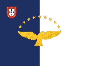
The Azores, officially the Autonomous Region of the Azores, is one of the two autonomous regions of Portugal. It is an archipelago composed of nine volcanic islands in the Macaronesia region of the North Atlantic Ocean, about 1,400 km (870 mi) west of Lisbon, about 1,500 km (930 mi) northwest of Morocco, and about 1,930 km (1,200 mi) southeast of Newfoundland, Canada.

<span class="mw-page-title-main">Prince Henry the Navigator</span> Portuguese navigator and Prince (1394–1460)

Dom Henrique of Portugal, Duke of Viseu, better known as Prince Henry the Navigator, was a central figure in the early days of the Portuguese Empire and in the 15th-century European maritime discoveries and maritime expansion. Through his administrative direction, he is regarded as the main initiator of what would be known as the Age of Discovery. Henry was the fourth child of King John I of Portugal, who founded the House of Aviz.

<span class="mw-page-title-main">History of Portugal (1415–1578)</span>

The history of the Kingdom of Portugal from the Illustrious Generation of the early 15th century to the fall of the House of Aviz in the late 16th century has been named the "Portuguese golden age" and the "Portuguese Renaissance". During this period, Portugal was the first European power to begin building a colonial empire as during the Age of Exploration Portuguese sailors and explorers discovered an eastern route to India as well as several Atlantic archipelagos and colonized the African coast and Brazil. They also explored the Indian Ocean and established trading routes throughout most of southern Asia, sending the first direct European maritime trade and diplomatic missions to Ming China and to Japan, at the same time installing trading posts and the most important colony: Portuguese Macau. The Portuguese Renaissance produced a plethora of poets, historians, critics, theologians, and moralists. The Cancioneiro Geral by Garcia de Resende is taken to mark the transition from Old Portuguese to the modern Portuguese language.

<span class="mw-page-title-main">Pico Island</span> Portuguese island in Azores archipelago

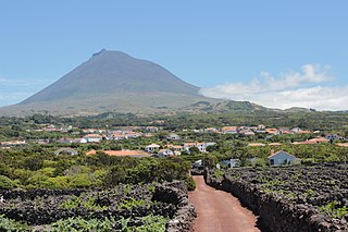
Pico Island is an island in the Central Group of the Portuguese Azores. The landscape features an eponymous volcano, Ponta do Pico, which is the highest mountain in Portugal, the Azores, and the highest elevation of the Mid-Atlantic Ridge. In the tradition of the Portuguese poet, Raul Brandão, Pico is referred to as the Ilha Preta, for its black volcanic soils, which nourish its UNESCO-designated vineyards that once allowed the development of the island's economy. Pico is the second largest and, geologically speaking, the most recently formed island of the Azores, being around 300,000 years old.

<span class="mw-page-title-main">Macaronesia</span> Archipelagos off the Atlantic coasts of Africa and Europe

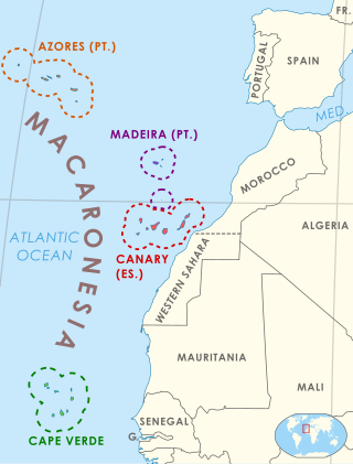
Macaronesia is a collection of four volcanic archipelagos in the North Atlantic, off the coasts of Africa and Europe. Each archipelago is made up of a number of Atlantic oceanic islands, which are formed by seamounts on the ocean floor whose peaks have risen above the ocean's surface. They are grouped politically into four groups- the Azores and Madeira archipelagos are part of Portugal, the Canary Islands are part of Spain, and the Cape Verde islands comprise their own sovereign nation. Politically, the islands belonging to Portugal and Spain are part of the European Union. Geologically, most of Macaronesia is part of the African tectonic plate. The Azores are located in the triple junction between the Eurasian, North American and African plates.

<span class="mw-page-title-main">Antillia</span> 15th-century phantom island

Antillia is a phantom island that was reputed, during the 15th-century age of exploration, to lie in the Atlantic Ocean, far to the west of Portugal and Spain. The island also went by the name of Isle of Seven Cities.

<span class="mw-page-title-main">Postage stamps and postal history of the Azores</span>

Postage stamps and postal history of the Azores surveys the postal history of the Portuguese archipelago, situated in the north Atlantic.

Diogo de Silves is the presumed name of an obscure Portuguese explorer of the Atlantic who allegedly discovered the Azores islands in 1427.

Vandino and Ugolino Vivaldi were two brothers and Genoese explorers and merchants who are best known for their attempted voyage from Europe to India via Africa. They set sail west from the Mediterranean into the Atlantic and were never heard from again.

<span class="mw-page-title-main">Mount Pico</span> Volcano in the Azores, Portugal

Mount Pico is a currently quiescent stratovolcano located on Pico Island, in the mid-Atlantic archipelago of the Azores. It is the highest mountain in Portugal, at 2,351 metres (7,713 ft) above sea level, and is one of the highest Atlantic mountains; it is more than twice the elevation of any other peak in the Azores. It has been a designated nature reserve since 1972.

<span class="mw-page-title-main">History of the Azores</span> History of the Azores

The following article describes the history of the Azores, an archipelago composed of nine volcanic islands in the Macaronesia region of the North Atlantic Ocean, about 1,400 km (870 mi) west of Lisbon, about 1,500 km (930 mi) northwest of Morocco, and about 1,930 km (1,200 mi) southeast of Newfoundland, Canada.

<span class="mw-page-title-main">Topo Volcanic Complex</span>

Volcanic Complex of Topo is a complex of scoria cones and volcanic structures, located near the village Topo in the southeastern part of the island of São Jorge, in the Portuguese archipelago of the Azores.

<span class="mw-page-title-main">Lopo Homem</span> 16th century Portuguese cartographer

Lopo Homem was a 16th-century Portuguese cartographer and cosmographer based in Lisbon and best known for his work on the Miller Atlas.

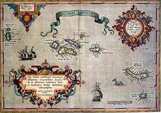
Gabriel de Vallseca, also referred to as Gabriel de Valseca and Gabriel de Valsequa was a cartographer of Jewish descent connected to the Majorcan cartographic school. His most notable map is the portolan of 1439, containing the first depiction of the recently-discovered Azores islands.

<span class="mw-page-title-main">Zuane Pizzigano</span>

Zuane Pizzigano, was a 15th-century Venetian cartographer. He is the author of a famous 1424 portolan chart, the first known to depict the phantom islands of the purported Antillia archipelago, in the north Atlantic Ocean.

The Weimar map is an anonymous 15th-century Italian portolan chart, held by the Grand Ducal Library of Weimar. Although frequently dated as 1424, most historians believe it was probably composed a half century later. The author is unknown, although said to be a member of the Freducci family of cartographers of Ancona, most probably Conte di Ottomano Freducci. Faint and fragile, the Weimar map is rarely photographed and has been hard to decipher.

The Corbitis Atlas is a late 14th-century atlas of four portolan charts, composed by an anonymous Venetian cartographer, and held by the Biblioteca Nazionale Marciana in Venice, Italy.

<span class="mw-page-title-main">Cornaro Atlas</span> Venetian collection of nautical charts and tracts

The Cornaro Atlas is an extensive Venetian collection of nautical charts and tracts, currently held in the Egerton Collection of manuscripts of the British Library.

The Captaincies of the Portuguese Empire were the socio-administrative territorial divisions and hereditary lordships established initially by Henry the Navigator, as part of the Donatário system in order to settle and developed the Portuguese overseas Empire. Pioneered on the island of Madeira and institutionalized in the archipelago of the Azores, the captaincy system was eventually adapted to the New World.

<i>Saudades da Terra</i>

Saudades da Terra is a manuscript, was published by father Gaspar Frutuoso,which forms a reference work on Macaronesia in the late 16th century.

References

  1. The existence of the Medici Atlas was announced and described in Theobald Fischer (1886: pp. 127–147).
  2. 1 2 3 4 Portolano Laurenziano Gaddiano by Henry Davis. Consulted 10 June 2011.]
  3. Armando Cortesão (1954 (1975):p. 78)
  4. Beazley
  5. Libro del Conoscimiento (1877: p. 60)
  6. Russell (2000: p. 122)
  7. Beazley (1899: cxxv)
  8. The 1341 expedition is related by Giovanni Boccaccio "De Canaria et insula reliquis, ultra Ispaniam, in occeano noviter repertis" (repr. in Monumenta Henricina, vol. I, pp. 202–06.)
  9. Libro de Conoscimiento (1877 ed.: p. 50)
  10. Amat di S. Filippo (1892). However, Marcel (1887: p. 31) suggest it may have already been hinted at in the Dulcert (1339) map, under the names St. Brendan, Primaria sive puellarum, Capraria and Canaria.
  11. Libro de Conoscimiento (1877 ed.: p. 50). The rest of the names are as given in the Catalan Atlas: S. Jorge as sant jorge (S. Jorge), ventura (Faial), colunbaria (Pico), brasil (Terceira), Cueruos marines (Corve) and los conjeos (Flores).

Sources