Shetland, also called the Shetland Islands, is an archipelago in Scotland lying between Orkney, the Faroe Islands, and Norway. It is the northernmost region of the United Kingdom.

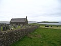
Fetlar is one of the North Isles of Shetland, Scotland, with a usually resident population of 61 at the time of the 2011 census. Its main settlement is Houbie on the south coast, home to the Fetlar Interpretive Centre. Other settlements include Aith, Funzie, Herra and Tresta. Fetlar is the fourth-largest island of Shetland and has an area of just over 4,000 ha.
Trondra is one of the Scalloway Islands, a subgroup of the Shetland Islands in Scotland. It shelters the harbour of Scalloway and has an area of 275 hectares (1.06 sq mi).

Google Maps is a web mapping platform and consumer application offered by Google. It offers satellite imagery, aerial photography, street maps, 360° interactive panoramic views of streets, real-time traffic conditions, and route planning for traveling by foot, car, bike, air and public transportation. As of 2020, Google Maps was being used by over one billion people every month around the world.

Orkney and Shetland is a constituency of the House of Commons of the Parliament of the United Kingdom. It elects one Member of Parliament (MP) by the first past the post system of election. In the Scottish Parliament, Orkney and Shetland are separate constituencies. The constituency was historically known as Orkney and Zetland.

Google Earth is a computer program that renders a 3D representation of Earth based primarily on satellite imagery. The program maps the Earth by superimposing satellite images, aerial photography, and GIS data onto a 3D globe, allowing users to see cities and landscapes from various angles. Users can explore the globe by entering addresses and coordinates, or by using a keyboard or mouse. The program can also be downloaded on a smartphone or tablet, using a touch screen or stylus to navigate. Users may use the program to add their own data using Keyhole Markup Language and upload them through various sources, such as forums or blogs. Google Earth is able to show various kinds of images overlaid on the surface of the Earth and is also a Web Map Service client. In 2019, Google revealed that Google Earth now covers more than 97 percent of the world, and has captured 10 million miles of Street View imagery.

Half Moon Island is a minor Antarctic island, lying in McFarlane Strait 1.35 km (0.84 mi) north of Burgas Peninsula, Livingston Island in the South Shetland Islands of the Antarctic Peninsula region. Its surface area is 171 hectares. The Argentine Cámara Base is located on the island. It is only accessible by sea and by helicopter; there is no airport of any kind. The naval base is operational occasionally during the summer, but is closed during the winter.
Sandness is a headland and district in the west of Shetland Mainland, Scotland. Sandness was a civil parish, which also included the island of Papa Stour some 1600 metres northwest across Papa Sound. In 1891, it was combined with Walls to the south, to form Walls and Sandness Parish, which had an administrative function until the abolition of Civil parishes in Scotland by the Local Government (Scotland) Act 1929, and had been a statistical regional unit since. Currently, the community council area of Sandness and Walls covers about the same area. The 1878 map of Sandness Parish shows that the parish to the east was Aithsting, before it was included into Sandsting to the south.

Assater is a hamlet on Mainland, in Shetland, Scotland. Assater is situated in the parish of Northmaven. It is about 1.3 miles (2.1 km) northwest of Urafirth and 1.2 miles (1.9 km) southeast of Heylor by road.
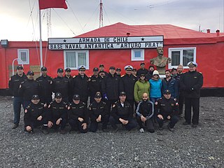
Captain Arturo Prat Base is a Chilean Antarctic research station located at Iquique Cove, Greenwich Island in the South Shetland Islands, Antarctica.

Ollaberry is a village on Mainland, Shetland, Scotland on the west shore of Yell Sound, 10.9 miles (17.5 km) north by road from Brae. Ollaberry Churchyard contains a Listed B monument, sculpted by John Forbes in 1754. Ollaberry Primary School was established in 1873.

Maldonado Base, also Pedro Vicente Maldonado Base, is the Ecuadorian Antarctic research base situated at Guayaquil Bay, Greenwich Island. It is located in the South Shetland Islands, Antarctica. It opened in 1990. The area was visited by early 19th century sealers operating from nearby Clothier Harbour.

Risopatrón Base, also Luis Risopatrón Base, is a small Chilean Antarctic research base in the northwest of Robert Island in the South Shetland Islands, Antarctica situated on the isthmus linking Coppermine Peninsula to Alfatar Peninsula and bounded by Carlota Cove to the north and Coppermine Cove to the south. Established as a refuge in 1949 and opened as a base in 1954, the facility supports summer research in geology, geophysics and terrestrial biology.
The following is a timeline for Google Street View, a technology implemented in Google Maps and Google Earth that provides ground-level interactive panoramas of cities. The service was first introduced in the United States on May 25, 2007, and initially covered only five cities: San Francisco, Las Vegas, Denver, Miami, and New York City. By the end of 2008, Street View had full coverage available for all of the major and minor cities in the continental United States, and had started expanding its scope to include some of the country's national parks, as well as cities elsewhere in the world. For the first year and a half of its existence, Street View featured camera icon markers, each representing at least one major city or area. By its 10th anniversary, the Street View service had provided imagery for more than 10 million miles' worth of roads across 83 countries worldwide.
Melby can refer to the following:

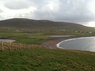
St Magnus Bay is a large coastal feature in the north-west of Mainland Shetland, Scotland. Roughly circular in shape with a diameter of about 19 kilometres (12 mi), it is open to the North Atlantic Ocean to the west. The indented coastline to the north, south and east between Esha Ness in the north and the Ness of Melby in the south contains numerous bays, firths and voes and there are several islands around the perimeter. The waters of the bay are up to 165 metres (541 ft) deep and may have been the site of a substantial meteor impact.
Lunning is a coastal hamlet in Mainland, Shetland Islands, Scotland, United Kingdom; the nearest settlement is Vidlin, and it is within the parish of Nesting. There is a standing stone near the settlement.

Holm of Melby is a small uninhabited island off Mainland, Shetland in Scotland. It lies in the Sound of Papa just offshore from the settlement of Melby in the district of Sandness.