The South Tynedale Railway is a preserved, 2 ft narrow gauge heritage railway in Northern England and is England's highest narrow gauge railway. The 2 ft line runs from Alston in Cumbria, up the South Tyne Valley, via Gilderdale, Kirkhaugh and Lintley, across the South Tyne, Gilderdale and Whitley Viaducts to Slaggyford in Northumberland.
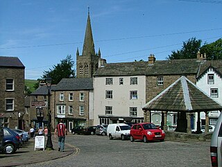
Alston is a small town in Cumbria, England, within the civil parish of Alston Moor on the River South Tyne. It shares the title of the 'highest market town in England', at about 1,000 feet (300 m) above sea level, with Buxton, Derbyshire. Despite being at such an altitude and in a remote location, the town is easily accessible via the many roads which link the town to Weardale valley, Teesdale, Hartside Pass as well as the Tyne valley. Historically part of Cumberland, Alston lies within the North Pennines, a designated Area of Outstanding Natural Beauty and is surrounded by beautiful views of the surrounding fells and the South Tyne Valley. Much of the town centre is a designated Conservation Area which includes several listed buildings.

Tynedale was a local government district in south-west Northumberland, England. It had a resident population of 58,808 according to the 2001 Census, and was named after the River Tyne. Its main towns were Hexham, Haltwhistle and Prudhoe. The district contained part of Hadrian's Wall.

Allendale, often marked on maps as Allendale Town, is a village and civil parish in south west Northumberland, England. At the 2001 census, the parish had a population of 2,120, decreasing to 2,021 at the 2011 Census. Allendale is within the North Pennines Area of Outstanding Natural Beauty (AONB) – the second largest of the 40 AONB's in England and Wales. The local economy is predominantly based on agriculture and tourism, although of late it has become a popular commuter town for Newcastle upon Tyne.

Wark on Tyne is a small village and civil parish usually called Wark in Northumberland, England about 12 miles (19 km) north of Hexham. The name is derived from the Viking word for Earthworks, and refers to the mound at the south of the village, where a meeting hall once stood. The hotel name 'battlesteads' is taken from the stables that once stood there, as the meeting hall was used as the main meeting place for the Clan Chieftains. Wark was also once the capital town of Tynedale, and still retains a Town Hall, rather than a Village Hall. A Bronze-age stone circle known as The Goatstones is located near Ravensheugh crags in Wark parish.

Broomley and Stocksfield was a civil parish in Northumberland, England. At the 2001 census, the parish, which included the village of Stocksfield, along with the hamlets of Branch End, Broomley, Hindley, New Ridley and Painshawfield, had a population of 3,039, falling slightly to 3,011 at the 2011 Census.

Hesket is a large civil parish in the Eden District of Cumbria, England. It was formed in 1934 by a County Review Order which merged the parishes of Hesket-in-the-Forest and Plumpton Wall.

Wetheral is a village, civil parish and electoral ward in Cumbria, England. The village serves mostly as a dormitory town for nearby Carlisle. At the 2001 census, the population of the Wetheral Ward was 4,039, The civil parish of Wetheral is slightly larger, with a population of 5,203. being counted as 4,541 at the 2011 Census for both Parish and Ward. Along with nearby Scotby, Wetheral is one of the most affluent villages in North Cumbria.

Greenhead is a village in Northumberland, England. The village is on the Military Road (B6318), about 17 miles (27 km) from Chollerford, 3 miles (5 km) from Haltwhistle and 9 miles (14 km) from Brampton, Cumbria along the A69 road. The A69 road bypasses the village, but until the 1980s all vehicular traffic passed through the village. The village lies just outside the Northumberland National Park, close to Hadrian's Wall. Just to the north of the village is the 12th-century Thirlwall Castle, recently restored and opened to the public. Nearby villages include Upper Denton and Haltwhistle.

The Alston line was a 13.5-mile (21.7 km) standard-gauge branch line railway that operated in the counties of Northumberland and Cumberland in England. Starting at its junction with the Newcastle and Carlisle Railway line at Haltwhistle, the line ran to the town of Alston. An 1846 Parliamentary Act authorised a line as far as Nenthead, providing an outlet for the lead mines in the Alston area, and plans were made to connect with railways further south. When the decision was made to terminate the branch at Alston, a further act was needed in 1849.

Tarset is a civil parish in Northumberland, England, created in 1955 from parts of Bellingham, Tarset West and Thorneyburn parishes. It is 4 miles (6 km) west-north-west of Bellingham. Today it shares a parish council with the adjacent parish of Greystead. It is partly located within the Northumberland National Park, and also mostly within the international dark skies park.

Commondale is a village and civil parish in the Scarborough district of North Yorkshire, England that lies within the North York Moors National Park. "Commondale" derives from the Gaelic Irish personal name Colmán.

Hough is a village and civil parish in the unitary authority of Cheshire East and the ceremonial county of Cheshire, England. The village is 3 miles (4.8 km) south of Crewe and 4 miles (6.4 km) east of Nantwich. The parish also includes part of the settlement of Goodalls Corner. The total population is a little over 800, measured at 808 in the 2011 Census. Nearby villages include Basford, Chorlton, Shavington, Weston and Wybunbury.
The ecclesiastical parish of Norton le Moors is located in the north-east of the city of Stoke-On-Trent, in the county of Staffordshire. The majority of the parish is in the city however some lies in the Staffordshire Moorlands district. Approximately 3.4 miles (5.5 km) north of Hanley, one of six major towns that joined together to form the city of Stoke-on-Trent in 1910. Norton le Moors borders Ball Green in the north, Stockton Brook in the east, Milton in the south, and Bradeley in the west, making it one of a number of small villages in the Stoke area.

Lambley, formerly known as Harper Town, is a village in Northumberland, England about four miles (6 km) southwest of Haltwhistle.The village lies adjacent to the River South Tyne. The place name Lambley refers to the "pasture of lambs". Lambley used to be the site of a small convent of Benedictine Nuns, founded by Adam de Tindale and Heloise, his wife, in the 12th century. The Scots led by William Wallace devastated it in 1296 [Rowland gives 1297]. However it was restored and one William Tynedale was ordained priest to the nunnery in about 1508 – most likely not William Tyndale, the reformer, as once believed but another man of the same name. At the time of the suppression of religious houses by Henry VIII, the nunnery contained six inmates. Nothing now remains but the bell from the nunnery, which hangs in the church, and a few carved stones. The village lies in the Midgeholme Coalfield and there are reserves of good-quality coal remaining.

Dalston is a large village and civil parish within the Carlisle district of Cumbria, England. It is situated on the B5299 road about four miles (6 km) south-south-west of Carlisle city centre, and approximately five miles (8 km) from Junction 42 of the M6 motorway.

Stapleton is a village and civil parish in the City of Carlisle district, in the county of Cumbria, in the North West of England. It falls under this jurisdiction of Cumbria County Council.

Kingwater is a civil parish in City of Carlisle district, Cumbria, England. At the 2011 census it had a population of 170.