Bardon Mill

Last updated

Bardon Mill
Bardon Mill in 2007.jpg
Northumberland UK location map.svg
Red pog.svg
Bardon Mill
Location within Northumberland
Population452 (2011 Census data for Bardon Mill Parish)
OS grid reference NY785645
Unitary authority
Ceremonial county
Region
Country England
Sovereign state United Kingdom
Post town Hexham
Postcode district NE47
Dialling code 01434
Police Northumbria
Fire Northumberland
Ambulance North East
UK Parliament
List of places
UK
England
Northumberland
54°58′30″N2°20′13″W / 54.975°N 2.337°W / 54.975; -2.337 Coordinates: 54°58′30″N2°20′13″W / 54.975°N 2.337°W / 54.975; -2.337

Bardon Mill is a small village in Northumberland, within the vicinity of the ancient Hadrian's Wall. It is located around 10+12 miles (17 kilometres) from Hexham, 26+12 mi (43 km) from Carlisle, and 32 mi (51 km) from Newcastle upon Tyne.

Contents

Nearby landmarks include Allen Banks & Staward Gorge, Sycamore Gap, The Sill: National Landscape Discovery Centre and Vindolanda Roman Fort.

Amenities

The local pub in Bardon Mill is The Bowes Hotel. Church services alternate weekly between St. Cuthbert's Church at Beltingham and the Church of All Hallows at Henshaw, both of which are very close to the village. There is a very active Women's Institute.

A leek club show is held every year, the produce from which is auctioned along with donations the day after the show. Funds are then donated to local charities.

Every October, there is the Bardon Mill and Roman Empire conkers championships, which is held on the village green. Local community projects are asked to run a stall at the event to raise funds for their own or community projects.

Demography

The data below shows that 49.3% of the population in Bardon Mill (Parish) are male, and 50.7% are female, which is similar to the national average (49.2 and 50.8% respectively) and the average within the county of Northumberland (48.8 and 51.2% respectively). [1] [2] [3]

A total of 1.8% of the population were from a black, Asian and minority ethnic (BAME) group in Bardon Mill (Parish). This figure is lower than that of the average in Northumberland (2.6%), as well as being significantly lower than the national average (14.6%). [1] [2] [3]

Data from the Office for National Statistics found that the average life expectancy in the Haydon and Hadrian electoral ward is 81.9 years for men, and 85.4 years for women. These statistics compare very favourably, when compared to the average life expectancy in the North East of England, of 77.4 and 81.4 years, for men and women respectively. [4]

Car ownership is very high in Bardon Mill (Parish), with a total of 95.3% households having access to at least one car. This is significantly higher than the average within Northumberland (78.0%), as well as the national average (74.2%). [1] [2] [3]

Demography (data from 2011 Census)
Demographic% of population
Bardon Mill (Parish) [1]
% of population
Northumberland [2]
% of population
England [3]
Total452316,02853,012,456
Male49.3%48.8%49.2%
Female50.7%51.2%50.8%
BAME 1.8%2.6%14.6%
Age 65+20.6%20.2%16.4%

Economy

The Errington Reay pottery Pottery in Bardon Mill - geograph.org.uk - 2004075.jpg
The Errington Reay pottery

The only commercial pottery in the United Kingdom currently licensed to produce salt glaze pottery is Errington Reay & Co., which was established in the village in 1878.

Education

Henshaw Church of England First School is located in the neighbouring village of Henshaw, providing education for students aged between 4 and 11 years old. The nearby Haltwhistle Academy provides education for students aged between 3 and 11 years old.

In terms of secondary education, Haydon Bridge High School provides secondary education for students aged between 11 and 16 years old, as well as post-16 study.

Folklore

A nearby farm is reputed to be haunted by the ghost of a robber, who was murdered there in the 14th century. The last alleged sighting was in 1933. [5]

Governance

Haydon and Hadrian is a local council ward in the county of Northumberland. This ward covers an area of around 89.1 square miles (230.8 km2), and has a population of 4,454. [6]

As of September 2020, the Haydon and Hadrian ward is served by Liberal Democrats councillor, Alan Sharp. [7]

The village is located within the parliamentary constituency of Hexham, and is served by Conservative Party Member of Parliament (MP), Guy Opperman. [8]

The village is also in two civil parishes, divided by the Chainley Burn. The west of the village is in Henshaw parish, while the eastern portion is in Bardon Mill parish, which also extends a long way south of the River South Tyne, as well as north of the village. [9]

Northumberland County Council Local Elections 2021: Haydon and Hadrian [10]
CandidatePolitical partyTotal votes% of votes
Alan Sharp  Liberal Democrats  83551.1%
Jan Harding  Conservative  48629.8%
David Clegg  Labour  22513.8%
Bill Day  Green  875.3%

Landmarks

Hadrian's Wall looking east from Housesteads. The Knag Burn Gateway is visible in the distance. Hadrians wall - geograph.org.uk - 946856.jpg
Hadrian's Wall looking east from Housesteads. The Knag Burn Gateway is visible in the distance.

A little over a mile to the south-west of the village is Willimoteswick Manor, a 16th-century fortified manor house, largely rebuilt in 1900. Just over a mile east of Bardon Mill is Ridley Hall and Allen Banks.

Ridley Hall was the ancestral home of a branch of the Bowes-Lyons, the late Queen Mother's family. Weddings and other functions are often held there including a Burns Night Ceilidh which is organised by the local church. The churches for the area are in Beltingham and Henshaw.

Allen Banks, which was formerly the estate belonging to the hall, were donated to the National Trust and includes 500 acres of riverbank and woodland walks, affording some of the best views in the area.

Northumberland National Park is located within a couple of miles of Bardon Mill. The northern end of the North Pennines is just a mile or so from here.

Vindolanda Roman settlement is in the parish just over one mile (1.5 kilometres) north of the A69. It is a world-renowned site and the location of the finding of the Vindolanda tablets – the oldest 'postcards' in the world. Some of these are to be found in the museum at Vindolanda along with a great many Roman finds from the days of the emperor Hadrian.

Hadrian's Wall is located three miles (five kilometres) north of Bardon Mill and is a World Heritage Site. Many people come from all over the world to see the Wall and the forts along it, the best preserved being Housesteads, which is located three miles (five kilometres) from the village. The Hadrian's Wall Path, covering a distance of 83 miles (134 km), as well as the Hadrian's Cycleway, both pass through the village.

Notable residents

Lilian Bowes-Lyon (1895–1949), was born and grew up at Ridley Hall, near Bardon Mill. She wrote many poems about Northumberland, including Allendale Dog and Northumbrian Farm. She was a cousin of Queen Elizabeth, the Queen Mother.

Transport

Air

The nearest airports are Carlisle Lake District Airport and Newcastle International Airport, which are located around 21+12 and 29+12 miles (35 and 47 km) from the village by road respectively.

Bus

The village is served by Arriva North East and Stagecoach Cumbria & North Lancashire's 685 bus service, which provides one bus per hour linking Carlisle, Brampton and Haltwhistle with Hexham, Corbridge and Newcastle.

Rail

The village is served by Bardon Mill station, which serves the Tyne Valley Line. Northern Trains provide 11 trains per day to Carlisle, and 13 trains per day to Hexham and Newcastle. From nearby Haltwhistle, which is located around five miles (eight kilometres) from the village, there is a more regular service provided, with two trains per hour to Carlisle, Hexham and Newcastle. [11]

Road

The village is located near to the A69 road, which runs for 54 miles (87 km) from Carlisle to the A1 at Denton Burn.

See also

Related Research Articles

<span class="mw-page-title-main">Stanegate</span> Roman road that ran from Carlisle to Corbridge, England

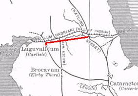
The Stanegate was an important Roman road built in what is now northern England. It linked many forts including two that guarded important river crossings: Corstopitum (Corbridge) on the River Tyne in the east, and situated on Dere Street, and Luguvalium (Carlisle) on the River Eden in the west. The Stanegate ran through the natural gap formed by the valleys of the River Tyne in Northumberland and the River Irthing in Cumbria. It predated Hadrian's Wall by several decades; the Wall would later follow a similar route, albeit slightly to the north.

<span class="mw-page-title-main">Hexham</span> Human settlement in England

Hexham is a market town and civil parish in Northumberland, England, on the south bank of the River Tyne, formed by the confluence of the North Tyne and the South Tyne at Warden nearby, and close to Hadrian's Wall. Hexham was the administrative centre for the Tynedale district from 1974 to 2009. In 2011, it had a population of 13,097.

<span class="mw-page-title-main">Tynedale</span> Former local government district in England

Tynedale was a local government district in Northumberland, England. The district had a resident population of 58,808 according to the 2001 census. The main towns were Hexham, Haltwhistle and Prudhoe. The district contained part of Hadrian's Wall and the southern part of Northumberland National Park.

<span class="mw-page-title-main">A69 road</span> Major trunk road in northern England

The A69 is a major northern trunk road in England, running east–west across the Pennines, through the counties of Tyne and Wear, Northumberland and Cumbria. Originally, the road started in the centre of Newcastle upon Tyne then later near Birtley, but since the creation of the A1 Western Bypass around Newcastle upon Tyne, it now starts at Denton Burn, a suburb of Newcastle upon Tyne.

<span class="mw-page-title-main">Haltwhistle</span> Human settlement in England

Haltwhistle is a market town and civil parish in Northumberland, England, ten miles east of Brampton. It had a population of 3,811 at the 2011 Census.

<span class="mw-page-title-main">Allendale, Northumberland</span> Human settlement in England

Allendale, often marked on maps as Allendale Town, is a village and civil parish in south west Northumberland, England. It is located within the North Pennines Area of Outstanding Natural Beauty.

<span class="mw-page-title-main">Haydon Bridge</span> Human settlement in England

Haydon Bridge is a village in Northumberland, England, which had a population of 2,184 in the 2011 census. Its most distinctive features are the two bridges crossing the River South Tyne: the picturesque original bridge for which the village was named and a modern bridge which used to carry the A69 road. A bypass was completed in 2009 and the A69 now bypasses the village to the south.

<span class="mw-page-title-main">Hadrian's Wall Path</span> Long-distance footpath in the north of England

Hadrian's Wall Path is a long-distance footpath in the north of England, which became the 15th National Trail in 2003. It runs for 84 miles (135 km), from Wallsend on the east coast of England to Bowness-on-Solway on the west coast. For most of its length it is close to the remains of Hadrian's Wall, the defensive wall built by the Romans on the northern border of their empire. This is now recognised as part of the "Frontiers of the Roman Empire" World Heritage Site.

<span class="mw-page-title-main">Riding Mill railway station</span> Railway station in Northumberland, England

Riding Mill is a railway station on the Tyne Valley Line, which runs between Newcastle and Carlisle via Hexham. The station, situated 16 miles 71 chains west of Newcastle, serves the villages of Broomhaugh and Riding Mill in Northumberland, England. It is owned by Network Rail and managed by Northern Trains.

<span class="mw-page-title-main">Bardon Mill railway station</span> Railway station in Northumberland, England

Bardon Mill is a railway station on the Tyne Valley Line, which runs between Newcastle and Carlisle via Hexham. The station, situated 27 miles 54 chains east of Carlisle, serves the village of Bardon Mill in Northumberland, England. It is owned by Network Rail and managed by Northern Trains.

<span class="mw-page-title-main">Haltwhistle railway station</span> Railway station in Northumberland, England

Haltwhistle is a railway station on the Tyne Valley Line, which runs between Newcastle and Carlisle via Hexham. The station, situated 22 miles 66 chains east of Carlisle, serves the market town of Haltwhistle in Northumberland, England. It is owned by Network Rail and managed by Northern Trains.

<span class="mw-page-title-main">Greenhead, Northumberland</span> Human settlement in England

Greenhead is a village in Northumberland, England. The village is on the Military Road (B6318), about 17 miles (27 km) from Chollerford, 3 miles (5 km) from Haltwhistle and 9 miles (14 km) from Brampton, Cumbria along the A69 road. The A69 bypasses the village, but until the 1980s all vehicular traffic passed through it. The village lies just outside the Northumberland National Park, close to Hadrian's Wall. Just to the north of the village is the 12th-century Thirlwall Castle, recently restored and opened to the public. Nearby villages include Upper Denton and Haltwhistle.

<span class="mw-page-title-main">Melkridge</span> Human settlement in England

Melkridge is a village and civil parish in Northumberland, England, on the river South Tyne. The village of Melkridge is in the south of the parish, and is about two miles (3 km) east of Haltwhistle along the A69 road. At the 2001 the civil parish had a population of 212, increasing slightly to 216 at the 2011 Census.

Henshaw is a small village and civil parish in Northumberland, within the vicinity of the ancient Hadrian's Wall. It is located around 11.5 miles (19 km) from Hexham, 25.5 miles (41 km) from Carlisle, and 33 miles (53 km) from Newcastle upon Tyne.

<span class="mw-page-title-main">Once Brewed</span> Human settlement in England

Once Brewed is a village in Northumberland, England. It lies on the Military Road (Northumberland) B6318. A motorist arriving over the B6138 from the east will see the place name shield "Once Brewed", while those coming from the west will read "Twice Brewed".

<span class="mw-page-title-main">Horsley, Northumberland</span> Human settlement in England

Horsley is a small village and civil parish in Northumberland, England. The village lies around 11 miles (18 km) from Newcastle upon Tyne and 12 miles (19 km) from Hexham.

<span class="mw-page-title-main">Tyne Valley line</span> Railway line in north of England

The Tyne Valley Line is a 58-mile (93 km) route, linking Newcastle upon Tyne with Hexham and Carlisle, England. The line follows the course of the River Tyne through Tyne and Wear and Northumberland. Five stations and two viaducts on the route are listed structures.

References

  1. 1 2 3 4 UK Census (2011). "Local Area Report – Bardon Mill (Parish) (as of 2011) (E04010738)". Nomis. Office for National Statistics . Retrieved 25 September 2020.
  2. 1 2 3 4 UK Census (2011). "Local Area Report – Northumberland Local Authority (E06000057)". Nomis. Office for National Statistics . Retrieved 25 September 2020.
  3. 1 2 3 4 UK Census (2011). "Local Area Report – England Country (E92000001)". Nomis. Office for National Statistics . Retrieved 25 September 2020.
  4. "Health state life expectancy by 2011 Census wards, England and Wales: 2009 to 2013". Office for National Statistics. 7 March 2018. Archived from the original on 19 July 2018. Retrieved 25 September 2020.
  5. Ash, Russell (1973). Folklore, Myths and Legends of Britain. Reader's Digest Association Limited. p. 336. ISBN   9780340165973.
  6. UK Census (2011). "Local Area Report – Haydon and Hadrian (as of 2011) (E05008047)". Nomis. Office for National Statistics . Retrieved 25 September 2020.
  7. "Councillors, Committees and Meetings". Northumberland County Council. Archived from the original on 16 August 2015. Retrieved 25 September 2020.
  8. "MPS representing Hexham (Constituency)". UK Parliament. Archived from the original on 5 August 2020. Retrieved 25 September 2020.
  9. Northumberland Parishes: Bardon Mill Parish Council
  10. "Declaration of result of poll: Haydon and Hadrian Division of Northumberland County Council" (PDF). Northumberland County Council. 5 May 2017. Archived (PDF) from the original on 9 May 2021. Retrieved 25 September 2020.
  11. "Train times: Sunderland and Newcastle to Hexham and Carlisle" (PDF). Northern Trains. 14 September 2020. Archived (PDF) from the original on 18 September 2020. Retrieved 25 September 2020.