
The administrative geography of the United Kingdom is complex, multi-layered and non-uniform. The United Kingdom, a sovereign state to the northwest of continental Europe, consists of England, Northern Ireland, Scotland and Wales. For local government in the United Kingdom, England, Northern Ireland, Scotland and Wales each have their own system of administrative and geographic demarcation. Consequently, there is "no common stratum of administrative unit encompassing the United Kingdom".
The subdivisions of England constitute a hierarchy of administrative divisions and non-administrative ceremonial areas.

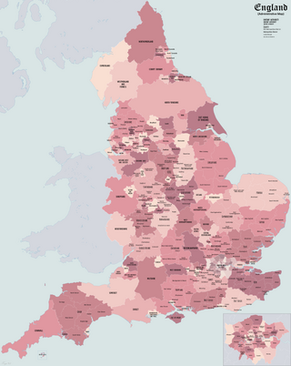
The districts of England are a level of subnational division of England used for the purposes of local government. As the structure of local government in England is not uniform, there are currently four principal types of district-level subdivision. There are a total of 296 districts made up of 36 metropolitan boroughs, 32 London boroughs, 164 two-tier non-metropolitan districts and 62 unitary authorities, as well as the City of London and the Isles of Scilly which are also districts, but do not correspond to any of these other categories. Some districts are styled as cities, boroughs or royal boroughs; these are purely honorific titles and do not alter the status of the district or the powers of their councils. All boroughs and cities are led by a mayor who in most cases is a ceremonial figure elected by the district council, but—after local government reform—is occasionally a directly elected mayor who makes most of the policy decisions instead of the council.

The counties of England are divisions of England. There are currently 48 ceremonial counties, which have their origin in the historic counties of England established in the Middle Ages. The current ceremonial counties are the result of the Lieutenancies Act 1997 and are based on the Local Government Act 1972 administrative counties which included a number of new counties such as Greater Manchester and Tyne and Wear. However, some counties introduced by the Local Government Act 1972, including Avon, Cleveland and Humberside no longer exist. The term "county", relating to any of its meanings, is used as the geographical basis for a number of institutions such as police and fire services, sports clubs and other non-government organisations.

Local government in England broadly consists of three layers: civil parishes, local authorities, and regional authorities. Every part of England is governed by at least one local authority, but parish councils and regional authorities do not exist everywhere. In addition, there are 31 police and crime commissioners, four police, fire and crime commissioners, and ten national park authorities with local government responsibilities. Local government is not standardised across the country, with the last comprehensive reform taking place in 1974.
The Metropolitan Borough of Wigan is a metropolitan borough of Greater Manchester, England. It is named after its largest town, Wigan but covers a far larger area which includes the towns of Atherton, Ashton-in-Makerfield, Golborne, Hindley, Ince-in-Makerfield, Leigh and Tyldesley. The borough also covers the villages and suburbs of Abram, Aspull, Astley, Bryn, Hindley Green, Lowton, Mosley Common, Orrell, Pemberton, Shevington, Standish, Winstanley and Worsley Mesnes. The borough is also the second-most populous district in Greater Manchester.

The Borough of Stockton-on-Tees is a unitary authority with borough status in the counties of County Durham and North Yorkshire, England. The borough had a population of 196,600 in 2021.
GSS codes are nine-character geocodes maintained by the United Kingdom's Office for National Statistics (ONS) to represent a wide range of geographical areas of the UK, for use in tabulating census and other statistical data. GSS refers to the Government Statistical Service of which ONS is part.
A county council is the elected administrative body governing an area known as a county. This term has slightly different meanings in different countries.

The Local Government Act 1972 is an act of the Parliament of the United Kingdom that reformed local government in England and Wales on 1 April 1974. It was one of the most significant Acts of Parliament to be passed by the Heath Government of 1970–74.
The counties of the United Kingdom are subnational divisions of the United Kingdom, used for the purposes of administrative, geographical and political demarcation. The older term, shire is historically equivalent to county. By the Middle Ages, county had become established as the unit of local government, at least in England. By the early 17th century, all of England, Wales, Scotland, and Ireland had been separated into counties. In Scotland shire was the only term used until after the Act of Union 1707.

Metropolitan and non-metropolitan counties are one of the four levels of subdivisions of England used for the purposes of local government outside Greater London and the Isles of Scilly. As originally constituted, the metropolitan and non-metropolitan counties each consisted of multiple districts, had a county council and were also the counties for the purposes of Lieutenancies. Later changes in legislation during the 1980s and 1990s have resulted in counties with no county council and 'unitary authority' counties with no districts. Counties for the purposes of Lieutenancies are now defined separately, based on the metropolitan and non-metropolitan counties.
The Local Government Act 1888 was an Act of Parliament which established county councils and county borough councils in England and Wales. It came into effect on 1 April 1889, except for the County of London, which came into existence on 21 March at the request of the London County Council.

The unitary authorities of England are a type of local authority responsible for all local government services in an area. They combine the functions of a non-metropolitan county council and a non-metropolitan district council, which elsewhere in England provide two tiers of local government.

The Council of the Isles of Scilly is a sui generis unitary local government authority covering the Isles of Scilly off the west coast of Cornwall. It is currently made up of 16 seats, with all councillors being independents. The council was created in 1890 as the Isles of Scilly Rural District Council and was renamed in 1974.
This article documents the strengths of political parties in the 317 local authorities of England, 32 local authorities of Scotland, 22 principal councils of Wales and 11 local councils of Northern Ireland.

North Lincolnshire Council is the local authority of North Lincolnshire, England. It is a unitary authority, having the powers of a county council and district council combined. It provides a full range of local government services including Council Tax billing, libraries, social services, town planning, and waste collection and disposal. It is also a local education authority. The council is based in Scunthorpe.

Southend-on-Sea City Council is the local authority of the Southend-on-Sea district in Essex, England. It is a unitary authority, having the powers of a non-metropolitan county and district council combined. It is a member of the East of England Local Government Association. It is based at Southend Civic Centre in Southend-on-Sea.
The Council of the Isles of Scilly is a sui generis authority in the ceremonial county of Cornwall, England, UK. It is elected every four years.
The Index of Place Names (IPN) in Great Britain is published by the Office for National Statistics.