List of electoral wards in Worcestershire

Last updated

This is a list of electoral divisions and wards in the ceremonial county of Worcestershire in the West Midlands. All changes since the re-organisation of local government following the passing of the Local Government Act 1972 are shown. The number of councillors elected for each electoral division or ward is shown in brackets.

Contents

County council

Worcestershire

Electoral Divisions from 1 April 1998 (first election 1 May 1997) to 5 May 2005: [1]

  1. Alvechurch (1)
  2. Barnt Green (1)
  3. Batchley (1)
  4. Bedwardine (1)
  5. Bowbrook (1)
  6. Bredon (1)
  7. Brinton Park (1)
  8. Broadway (1)
  9. Bromsgrove North (1)
  10. Bromsgrove South (1)
  11. Bromsgrove West (1)
  12. Chaddesley (1)
  13. Church Hill (1)
  14. Claines (1)
  15. Cookley, Wolverley & Wribbenhall (1)
  16. Crabbs Cross (1)
  17. Croome (1)
  18. Droitwich Rural (1)
  19. Droitwich South (1)
  20. Droitwich Town (1)
  21. Evesham Hampton (1)
  22. Evesham Town (1)
  23. Habberley & Blakebrook (1)
  24. Hagley & Furlongs (1)
  25. Hallow (1)
  26. Hoobrook (1)
  27. Hurcott (1)
  28. Inkberrow (1)
  29. Lodge Park (1)
  30. Malvern Chase (1)
  31. Malvern Langland (1)
  32. Malvern Link (1)
  33. Malvern Trinity (1)
  34. Matchborough (1)
  35. Mitton (1)
  36. Nunnery (1)
  37. Pershore Town (1)
  38. Powick (1)
  39. Puxton (1)
  40. Redditch Central (1)
  41. Redditch West (1)
  42. Rock & Bewdley (1)
  43. Rubery (1)
  44. Severn (1)
  45. St Barnabas (1)
  46. St Chad (1)
  47. St Clement (1)
  48. St John (1)
  49. St Martin (1)
  50. St Peter (1)
  51. St Stephen (1)
  52. Tenbury (1)
  53. The Littletons (1)
  54. Uffdown (1)
  55. Winyates (1)
  56. Woodvale (1)
  57. Wythall (1)

Electoral Divisions from 5 May 2005 to present: [2]

Worcestershire UK electoral division map (blank).svg
  1. Alvechurch (1)
  2. Arrow Valley East (2)
  3. Arrow Valley West (2)
  4. Beacon (1)
  5. Bedwardine (1)
  6. Bewdley (1)
  7. Bowbrook (1)
  8. Bredon (1)
  9. Broadway (1)
  10. Bromsgrove Central (1)
  11. Bromsgrove East (1)
  12. Bromsgrove South (1)
  13. Bromsgrove West (1)
  14. Chaddesley (1)
  15. Claines (1)
  16. Clent Hills (1)
  17. Cookley, Wolverley & Wribbenhall (1)
  18. Croome (1)
  19. Droitwich East (1)
  20. Droitwich West (1)
  21. Evesham North West (1)
  22. Evesham South (1)
  23. Gorse Hill & Warndon (1)
  24. Hallow (1)
  25. Harvington (1)
  26. Littletons (1)
  27. Malvern Chase (1)
  28. Malvern Langland (1)
  29. Malvern Link (1)
  30. Malvern Trinity (1)
  31. Nunnery (1)
  32. Ombersley (1)
  33. Pershore (1)
  34. Powick (1)
  35. Rainbow Hill (1)
  36. Redditch North (2)
  37. Redditch South (2)
  38. Riverside (1)
  39. St Barnabas (1)
  40. St Chads (1)
  41. St Georges & St Oswald (1)
  42. St John (1)
  43. St Johns (1)
  44. St Marys (1)
  45. St Peter (1)
  46. St Stephen (1)
  47. Stourport-on-Severn (2)
  48. Tenbury (1)
  49. Upton Snodsbury (1)
  50. Warndon Parish (1)
  51. Woodvale (1)
  52. Wythall (1)

District councils

Bromsgrove

Wards from 1 April 1974 (first election 7 June 1973) to 3 May 1979: [3]

Wards from 3 May 1979 to 1 May 2003: [4]

  1. Uffdown (); ward abolished in 1995 [5]
  2. Waseley (); ward abolished in 1995 [5]
  3. Uffdown & Waseley (3); new ward added in 1995 [5]

Wards from 1 May 2003 to 7 May 2015: [6]

Bromsgrove UK ward map 2010 (blank).svg
  1. Alvechurch (3)
  2. Beacon (1)
  3. Catshill (2)
  4. Charford (2)
  5. Drakes Cross & Walkers Heath (2)
  6. Furlongs (2)
  7. Hagley (2)
  8. Hillside (2)
  9. Hollywood & Majors Green (2)
  10. Linthurst (1)
  11. Marlbrook (2)
  12. Norton (2)
  13. St Johns (2)
  14. Sidemoor (2)
  15. Slideslow (2)
  16. Stoke Heath (1)
  17. Stoke Prior (1)
  18. Tardebigge (1)
  19. Uffdown (1)
  20. Waseley (2)
  21. Whitford (2)
  22. Woodvale (1)
  23. Wythall South (1)

Wards from 7 May 2015 to present: [7]

Bromsgrove UK ward map 2015 (blank).svg
  1. Alvechurch South (1)
  2. Alvechurch Village (1)
  3. Aston Fields (1)
  4. Avoncroft (1)
  5. Barnt Green & Hopwood (1)
  6. Belbroughton & Romsley (2)
  7. Bromsgrove Central (1)
  8. Catshill North (1)
  9. Catshill South (1)
  10. Charford (1)
  11. Cofton (1)
  12. Drakes Cross (1)
  13. Hagley East (1)
  14. Hagley West (1)
  15. Hill Top (1)
  16. Hollywood (1)
  17. Lickey Hills (1)
  18. Lowes Hill (1)
  19. Marlbrook (1)
  20. Norton (1)
  21. Perryfields (1)
  22. Rock Hill (1)
  23. Rubery North (1)
  24. Rubery South (1)
  25. Sanders Park (1)
  26. Sidemoor (1)
  27. Slideslow (1)
  28. Tardebigge (1)
  29. Wythall East (1)
  30. Wythall West (1)

Malvern Hills

Wards from 1 April 1974 (first election 7 June 1973) to 3 May 1979: [3]

Wards from 3 May 1979 to 1 May 1997: [8]

Wards from 1 May 1997 to 1 May 2003: [1]

  1. Baldwin (1)
  2. Bayton & Mamble (1)
  3. Broadheath (1)
  4. Chase (3)
  5. Hallow (1)
  6. Kempsey (2)
  7. Kyre Vale (1)
  8. Langland (3)
  9. Laugherne Hill (1)
  10. Leigh & Bransford (1)
  11. Lindridge (1)
  12. Link (3)
  13. Longdon (1)
  14. Martley (1)
  15. Morton (1)
  16. Powyke (2)
  17. Priory (2)
  18. Ripple (1)
  19. Temeside (1)
  20. Tenbury Town (2)
  21. The Hanleys (1)
  22. Trinity (3)
  23. Upton-upon-Severn (2)
  24. Valley of the Teme (1)
  25. Wells (2)
  26. West (2)
  27. Woodbury (1)

Wards from 1 May 2003 to present: [9]

Malvern Hills UK ward map 2010 (blank).svg
  1. Alfrick & Leigh (2)
  2. Baldwin (1)
  3. Broadheath (2)
  4. Chase (3)
  5. Dyson Perrins (2)
  6. Hallow (1)
  7. Kempsey (2)
  8. Lindridge (1)
  9. Link (3)
  10. Longdon (1)
  11. Martley (1)
  12. Morton (1)
  13. Pickersleigh (3)
  14. Powick (2)
  15. Priory (2)
  16. Ripple (1)
  17. Teme Valley (1)
  18. Tenbury (2)
  19. Upton & Hanley (2)
  20. Wells (2)
  21. West (2)
  22. Woodbury (1)

Redditch

Wards from 1 April 1974 (first election 7 June 1973) to 5 May 1983: [3]

  1. Batchley (3)
  2. Central (3)
  3. Crabbs Cross (3)
  4. East (2)
  5. Feckenham (2)
  6. Greenlands (7)
  7. North (2)
  8. West (3)

Wards from 5 May 1983 to 10 June 2004: [10]

  1. Abbey (2)
  2. Batchley (3)
  3. Central (3)
  4. Church Hill (2)
  5. Crabbs Cross (2)
  6. Feckenham (2)
  7. Greenlands (3)
  8. Lodge Park (3)
  9. Matchborough (3)
  10. West (3)
  11. Winyates (3)

Wards from 10 June 2004 to present: [11]

Redditch UK ward map 2010 (blank).svg
  1. Abbey (2)
  2. Astwood Bank & Feckenham (2)
  3. Batchley (3); renamed Batchley & Brockhill in 2008 [12]
  4. Central (2)
  5. Church Hill (3)
  6. Crabbs Cross (2)
  7. Greenlands (3)
  8. Headless Cross & Oakenshaw (3)
  9. Lodge Park (2)
  10. Matchborough (2)
  11. West (2)
  12. Winyates (3)

Worcester

Wards from 1 April 1974 (first election 7 June 1973) to 3 May 1979: [3]

Wards from 3 May 1979 to 10 June 2004: [13]

Wards from 10 June 2004 to present: [14]

Worcester UK ward map 2010 (blank).svg
  1. Arboretum (2)
  2. Battenhall (2)
  3. Bedwardine (3)
  4. Cathedral (3)
  5. Claines (3)
  6. Gorse Hill (2)
  7. Nunnery (3)
  8. Rainbow Hill (2)
  9. St Clement (2)
  10. St John (3)
  11. St Peter’s Parish (2)
  12. St Stephen (2)
  13. Warndon (2)
  14. Warndon Parish North (2)
  15. Warndon Parish South (2)

Wychavon

Wards from 1 April 1974 (first election 7 June 1973) to 3 May 1979: [3]

Wards from 3 May 1979 to 1 May 2003: [15]

  1. Claines Central & West (); ward abolished in 1987 [16]
  2. Claines East (); ward abolished in 1987 [16]
  3. North Claines (2); new ward added in 1987 [16]

Wards from 1 May 2003 to present: [17]

Wychavon UK ward map 2010 (blank).svg
  1. Badsey (1)
  2. Bengeworth (2)
  3. Bowbrook (1)
  4. Bredon (1)
  5. Bretforton & Offenham (1)
  6. Broadway & Wickhamford (2)
  7. Dodderhill (1)
  8. Drakes Broughton (1)
  9. Droitwich Central (1)
  10. Droitwich East (2)
  11. Droitwich South East (2)
  12. Droitwich South West (2)
  13. Droitwich West (2)
  14. Eckington (1)
  15. Elmley Castle & Somerville (1)
  16. Evesham North (2)
  17. Evesham South (2)
  18. Fladbury (1)
  19. Great Hampton (1)
  20. Hartlebury (1)
  21. Harvington & Norton (1)
  22. Honeybourne & Pebworth (1)
  23. Inkberrow (2)
  24. Little Hampton (2)
  25. Lovett & North Claines (2)
  26. Norton & Whittington (1)
  27. Ombersley (1)
  28. Pershore (3)
  29. Pinvin (1)
  30. South Bredon Hill (1)
  31. The Littletons (1)
  32. Upton Snodsbury (1)

Wyre Forest

Wards from 1 April 1974 (first election 7 June 1973) to 3 May 1979: [3]

Wards from 3 May 1979 to 10 June 2004: [18]

Wards from 10 June 2004 to 7 May 2015: [19]

Wyre Forest UK ward map 2010 (blank).svg
  1. Aggborough & Spennells (3)
  2. Areley Kings (3)
  3. Bewdley & Arley (3)
  4. Blakedown & Chaddesley (2)
  5. Broadwaters (3)
  6. Cookley (1)
  7. Franche (3)
  8. Greenhill (3)
  9. Habberley & Blakebrook (3)
  10. Lickhill (3)
  11. Mitton (3)
  12. Offmore & Comberton (3)
  13. Oldington & Foley Park (2)
  14. Rock (1)
  15. Sutton Park (3)
  16. Wolverley (1)
  17. Wribbenhall (2)

Wards from 7 May 2015 to present: [20]

Wyre Forest UK ward map 2015 (blank).svg
  1. Aggborough & Spennells (3)
  2. Areley Kings & Riverside (3)
  3. Bewdley & Rock (3)
  4. Blakebrook & Habberley South (3)
  5. Broadwaters (3)
  6. Foley Park & Hoobrook (3)
  7. Franche & Habberley North (3)
  8. Lickhill (1)
  9. Mitton (3)
  10. Offmore & Comberton (3)
  11. Wribbenhall & Arley (2)
  12. Wyre Forest Rural (3)

Former county council

Hereford and Worcester

Electoral Divisions from 1 April 1974 (first election 12 April 1973) to 2 May 1985: [21] [22] [23]

  1. Alvechurch & Cofton Hackett (1)
  2. Belbroughton (1)
  3. Bewdley No. 1 (1)
  4. Bewdley No. 2 (1)
  5. Bromsgrove East (1)
  6. Bromsgrove North (1)
  7. Bromsgrove North West (1)
  8. Bromsgrove South (1)
  9. Bromsgrove South East (1)
  10. Bromsgrove West (1)
  11. Bromyard (1)
  12. Chaddesley Corbett (1)
  13. Croome (1)
  14. Dore & Bredwardine (1)
  15. Droitwich North (1)
  16. Droitwich Rural No. 1 (1)
  17. Droitwich Rural No. 2 (1)
  18. Droitwich Rural No. 3 (1)
  19. Droitwich South (1)
  20. Evesham East (1)
  21. Evesham Rural No. 1 (1)
  22. Evesham Rural No. 2 (1)
  23. Evesham Rural No. 3 (1)
  24. Evesham West (1)
  25. Hagley (1)
  26. Hereford No. 1 (Bartonsham) (1)
  27. Hereford No. 2 (2)
  28. Hereford No. 3 (Holmer) (1)
  29. Hereford No. 4 (St Martins) (2)
  30. Hereford No. 5 (North Tupsley) (1)
  31. Hereford No. 6 (South Tupsley) (1)
  32. Hereford Rural No. 1 (1)
  33. Hereford Rural No. 2 (1)
  34. Hereford Rural No. 3 (1)
  35. Kidderminster Baxter (1)
  36. Kidderminster Oldington (1)
  37. Kidderminster Park (1)
  38. Kidderminster Rowland Hill (1)
  39. Kidderminster St Georges (1)
  40. Kidderminster St Johns (2)
  41. Kidderminster St Marys (1)
  42. Kington (1)
  43. Ledbury No. 1 (1)
  44. Ledbury No. 2 (1)
  45. Leominster & Wigmore No. 1 (1)
  46. Leominster & Wigmore No. 2 (1)
  47. Leominster (1)
  48. Malvern East (1)
  49. Malvern North (1)
  50. Malvern South (1)
  51. Malvern West (1)
  52. Martley No. 1 (1)
  53. Martley No. 2 (1)
  54. Pershore No. 1 (1)
  55. Pershore No. 2 (1)
  56. Pershore No. 3 (1)
  57. Powick (1)
  58. Redditch No. 1 (1)
  59. Redditch No. 2 (1)
  60. Redditch No. 3 (1)
  61. Redditch No. 4 (1)
  62. Redditch No. 5 (1)
  63. Redditch No. 6 (2)
  64. Ross & Whitchurch No. 1 (1)
  65. Ross & Whitchurch No. 2 (1)
  66. Ross-on-Wye (1)
  67. Stoke Prior (1)
  68. Stourport No. 1 (1)
  69. Stourport No. 2 (1)
  70. Stourport No. 3 (1)
  71. Tenbury (1)
  72. Upton-on-Severn (1)
  73. Weobley (1)
  74. Wolverley & Cookley (1)
  75. Worcester No. 1 (All Saints) (1)
  76. Worcester No. 2 (Bedwardine) (1)
  77. Worcester No. 3 (Claines) (1)
  78. Worcester No. 4 (Holy Trinity) (1)
  79. Worcester No. 5 (Nunnery) (1)
  80. Worcester No. 6 (St Barnabas) (1)
  81. Worcester No. 7 (St Clement) (1)
  82. Worcester No. 8 (St John) (1)
  83. Worcester No. 9 (St Martin) (1)
  84. Worcester No. 10 (St Nicholas) (1)
  85. Worcester No. 11 (St Peter) (1)
  86. Worcester No. 12 (St Stephen) (1)
  87. Wythall North (1)
  88. Wythall South (1)

Electoral Divisions from 2 May 1985 to 1 April 1998 (county abolished): [24] [25]

  1. Alvechurch (1)
  2. Barnt Green (1)
  3. Batchley (1)
  4. Bedwardine (1)
  5. Bowbrook (1)
  6. Bredon (1)
  7. Brinton Park (1)
  8. Broadway (1)
  9. Bromsgrove North (1)
  10. Bromsgrove South (1)
  11. Bromsgrove West (1)
  12. Bromyard (1)
  13. Central & St Nicholas (1)
  14. Chaddesley (1)
  15. Church Hill (1)
  16. Claines (1)
  17. College (1)
  18. Cookley Wolverley & Wribbenhall (1)
  19. Crabbs Cross (1)
  20. Croome (1)
  21. Dinmore (1)
  22. Dore & Bredwardine (1)
  23. Droitwich Rural (1)
  24. Droitwich South (1)
  25. Droitwich Town (1)
  26. Evesham Hampton (1)
  27. Evesham Town (1)
  28. Habberley & Blakebrook (1)
  29. Hagley & Furlongs (1)
  30. Hallow (1)
  31. Hinton & Hunderton (1)
  32. Hoobrook (1)
  33. Hope End (1)
  34. Hurcott (1)
  35. Inkberrow (1)
  36. Kington & Wigmore (1)
  37. Ledbury (1)
  38. Leominster (1)
  39. Leominster Rural (1)
  40. Lodge Park (1)
  41. Malvern Chase (1)
  42. Malvern Langland (1)
  43. Malvern Link (1)
  44. Malvern Trinity (1)
  45. Matchborough (1)
  46. Mitton (1)
  47. Nunnery (1)
  48. Pershore Town (1)
  49. Powick (1)
  50. Puxton (1)
  51. Redditch Central (1)
  52. Redditch West (1)
  53. Redhill & Newton Farm (1)
  54. Rock & Bewdley (1)
  55. Ross Rural (1)
  56. Ross-on-Wye (1)
  57. Rubery (1)
  58. Severn (1)
  59. St Barnabas (1)
  60. St Chad (1)
  61. St Clement (1)
  62. St John (1)
  63. St Martin (1)
  64. St Peter (1)
  65. St Stephen (1)
  66. Tenbury (1)
  67. The Littletons (1)
  68. Thinghill (1)
  69. Three Elms (1)
  70. Tupsley (1)
  71. Uffdown (1)
  72. Weobley (1)
  73. Winyates (1)
  74. Woodvale (1)
  75. Wormelow (1)
  76. Wythall (1)

Former district council

Leominster

See: List of electoral wards in Herefordshire#Leominster

Electoral wards by constituency

Bromsgrove

Alvechurch, Beacon, Catshill, Charford, Drakes Cross and Walkers Heath, Furlongs, Hagley, Hillside, Hollywood and Majors Green, Linthurst, Marlbrook, Norton, St Johns, Sidemoor, Slideslow, Stoke Heath, Stoke Prior, Tardebigge, Uffdown, Waseley, Whitford, Woodvale, Wythall South.

Mid Worcestershire

Badsey, Bengeworth, Bowbrook, Bretforton and Offenham, Broadway and Wickhamford, Dodderhill, Drakes Broughton, Droitwich Central, Droitwich East, Droitwich South East, Droitwich South West, Droitwich West, Evesham North, Evesham South, Fladbury, Great Hampton, Hartlebury, Harvington and Norton, Honeybourne and Pebworth, Little Hampton, Lovett and North Claines, Norton and Whittington, Ombersley, Pinvin, The Littletons, Upton Snodsbury.

Redditch

Abbey, Astwood Bank and Feckenham, Batchley, Central, Church Hill, Crabbs Cross, Greenlands, Headless Cross and Oakenshaw, Inkberrow, Lodge Park, Matchborough, West, Winyates.

West Worcestershire

Alfrick and Leigh, Baldwin, Bredon, Broadheath, Chase, Dyson Perrins, Eckington, Elmley Castle and Somerville, Hallow, Kempsey, Lindridge, Link, Longdon, Martley, Morton, Pershore, Pickersleigh, Powick, Priory, Ripple, South Bredon Hill, Teme Valley, Tenbury, Upton and Hanley, Wells, West, Woodbury.

See also

Related Research Articles

<span class="mw-page-title-main">Worcestershire</span> County of England

Worcestershire is a ceremonial county in the West Midlands of England. It borders Shropshire, Staffordshire, and the West Midlands county to the north, Warwickshire to the east, Gloucestershire to the south, and Herefordshire to the west. The largest settlement is the city of Worcester.

<span class="mw-page-title-main">Wychavon</span> Non-metropolitan district in England

<span class="mw-page-title-main">History of Worcestershire</span>

The area now known as Worcestershire has had human presence for over half a million years. Interrupted by two ice ages, Worcestershire has had continuous settlement since roughly 10,000 years ago. In the Iron Age, the area was dominated by a series of hill forts, and the beginnings of industrial activity including pottery and salt mining can be found. It seems to have been relatively unimportant during the Roman era, with the exception of the salt workings.

<span class="mw-page-title-main">Mid Worcestershire (UK Parliament constituency)</span>

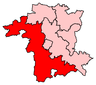
Mid Worcestershire is a constituency represented in the House of Commons of the UK Parliament since 2015 by Nigel Huddleston, a Conservative.

<span class="mw-page-title-main">West Worcestershire (UK Parliament constituency)</span> Parliamentary constituency in the United Kingdom, 1997 onwards

West Worcestershire is a constituency in Worcestershire represented in the House of Commons of the UK Parliament since 2010 by Harriett Baldwin, a Conservative. The constituency is considered a safe seat for the Conservatives. The constituency boundaries roughly correspond with the Malvern Hills District.

Bromsgrove District Council elections are held every four years. Bromsgrove District Council is the local authority for the non-metropolitan district of Bromsgrove in Worcestershire, England. Since the last boundary changes in 2015, 31 councillors are elected from 30 wards.

<span class="mw-page-title-main">Kidderminster (UK Parliament constituency)</span> Parliamentary constituency in the United Kingdom, 1832–1983

Kidderminster was a parliamentary constituency in Worcestershire, represented in the House of Commons of the Parliament of the United Kingdom. It elected one Member of Parliament (MP) by the first past the post voting system.

<span class="mw-page-title-main">Droitwich Spa railway station</span> Railway station in Worcestershire, England

Droitwich Spa railway station serves the town of Droitwich Spa in Worcestershire, England. It is located just to the south-west of Droitwich Spa Junction of the Worcester to Leamington Spa Line and the Worcester to Birmingham New Street line. The station is managed by West Midlands Trains, who also operate all trains serving it.

The Worcestershire Senior Cup is a football competition organised by the Worcestershire County Football Association. It began in the 1893-94 season, with Redditch Town taking the first honours. Due to the dearth of professional clubs within the county, few professional teams have taken part, though Walsall, Aston Villa, and Kidderminster Harriers are past winners.

The Worcestershire Senior Urn is a football competition for Worcestershire County FA club teams, organized by the Worcestershire County Football Association. It began in the 1973–74 season with Malvern Town taking the honours in the first final.

The Worcestershire County Cricket League (WCL) is an English club cricket league, and consists of club teams primarily from Worcestershire, as well as several other clubs from bordering counties Herefordshire, Shropshire, Staffordshire and Warwickshire.

<span class="mw-page-title-main">Worcestershire in the English Civil War</span>

Worcestershire was the county where the first battle and last battle of the English Civil War took place. The first battle, the Battle of Powick Bridge, fought on 23 September 1642, was a cavalry skirmish and a victory for the Royalists (Cavaliers). The final battle, the battle of Worcester, fought on 3 September 1651, was decisive and ended the war with a Parliamentary (Roundhead) victory and King Charles II a wanted fugitive.

<span class="mw-page-title-main">Evolution of Worcestershire county boundaries since 1844</span>

The administrative boundaries of Worcestershire, England have been fluid for over 150 years since the first major changes in 1844. There were many detached parts of Worcestershire in the surrounding counties, and conversely there were islands of other counties within Worcestershire. The 1844 Counties Act began the process of eliminating these, but the process was not completed until 1966, when Dudley was absorbed into Staffordshire.

The North Midlands Rugby Football Union is a governing body for rugby union in part of The Midlands, England. The union is the constituent body of the Rugby Football Union for the counties of Herefordshire, Shropshire, Worcestershire and the Greater Birmingham area.

References

  1. 1 2 legislation.gov.uk - The Hereford and Worcester (Structural, Boundary and Electoral Changes) Order 1996. Retrieved on 6 November 2015.
  2. legislation.gov.uk - The County of Worcestershire (Electoral Changes) Order 2005. Retrieved on 3 November 2015.
  3. 1 2 3 4 5 6 The County of Hereford and Worcester (District Wards) Order 1973
  4. The District of Bromsgrove (Electoral Arrangements) Order 1977
  5. 1 2 3 legislation.gov.uk - The District of Bromsgrove (Electoral Arrangements) Order 1995. Retrieved on 4 November 2015.
  6. legislation.gov.uk - The District of Bromsgrove (Electoral Changes) Order 2003. Retrieved on 3 November 2015.
  7. legislation.gov.uk - The Bromsgrove (Electoral Changes) Order 2014. Retrieved on 3 November 2015.
  8. The District of Malvern Hills (Electoral Arrangements) Order 1976
  9. legislation.gov.uk - The District of Malvern Hills (Electoral Changes) Order 2002. Retrieved on 4 October 2015.
  10. The District of Redditch (Electoral Arrangements) Order 1980
  11. legislation.gov.uk - The Borough of Redditch (Electoral Changes) Order 2002. Retrieved on 4 October 2015.
  12. Redditch Borough Council letter dated 1 April 2008
  13. The City of Worcester (Electoral Arrangements) Order 1977
  14. legislation.gov.uk - The City of Worcester (Electoral Changes) Order 2002. Retrieved on 4 October 2015.
  15. The District of Wychavon (Electoral Arrangements) Order 1978
  16. 1 2 3 legislation.gov.uk - The Hereford and Worcester (District Boundaries) Order 1987. Retrieved on 6 November 2015.
  17. legislation.gov.uk - The District of Wychavon (Electoral Changes) Order 2002. Retrieved on 4 October 2015.
  18. The District of Wyre Forest (Electoral Arrangements) Order 1978
  19. legislation.gov.uk - The District of Wyre Forest (Electoral Changes) Order 2002. Retrieved on 4 October 2015.
  20. legislation.gov.uk - The Wyre Forest (Electoral Changes) Order 2015. Retrieved on 3 November 2015.
  21. The County of Hereford and Worcester (Electoral Divisions) Order 1973
  22. Rallings, Colin; Thrasher, Michael. Local Elections Handbook 1973. The Elections Centre. Retrieved 3 May 2016.
  23. Rallings, Colin; Thrasher, Michael. Local Elections Handbook 1977. The Elections Centre. Retrieved 3 May 2016.
  24. The County of Hereford and Worcester (Electoral Arrangements) Order 1983
  25. Rallings, Colin; Thrasher, Michael. Local Elections Handbook 1985, Volume 3. The Elections Centre. Retrieved 3 May 2016.