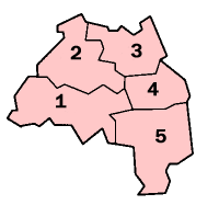
List of electoral wards in Tyne and Wear

Last updated

This is a list of electoral divisions and wards in the ceremonial county of Tyne and Wear in North East England. All changes since the re-organisation of local government following the passing of the Local Government Act 1972 are shown. The number of councillors elected for each electoral division or ward is shown in brackets.

Contents

District councils

Gateshead

Wards from 1 April 1974 (first election 10 May 1973) to 6 May 1982:

Wards from 6 May 1982 to 10 June 2004: [1]

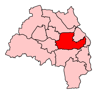
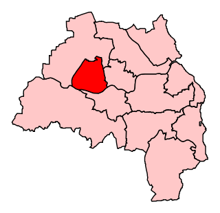
Wards from 10 June 2004 to present: [2]

Gateshead UK ward map 2010 (blank).svg
  1. Birtley (3)
  2. Blaydon (3)
  3. Bridges (3)
  4. Chopwell & Rowlands Gill (3)
  5. Chowdene (3)
  6. Crawcrook & Greenside (3)
  7. Deckham (3)
  8. Dunston & Teams (3)
  9. Dunston Hill & Whickham East (3)
  10. Felling (3)
  11. High Fell (3)
  12. Lamesley (3)
  13. Lobley Hill & Bensham (3)
  14. Low Fell (3)
  15. Pelaw & Heworth (3)
  16. Ryton, Crookhill & Stella (3)
  17. Saltwell (3)
  18. Wardley & Leam Lane (3)
  19. Whickham North (3)
  20. Whickham South & Sunniside (3)
  21. Windy Nook & Whitehills (3)
  22. Winlaton & High Spen (3)

Newcastle upon Tyne

Wards from 1 April 1974 (first election 10 May 1973) to 6 May 1982:

Wards from 6 May 1982 to 10 June 2004: [3]

Wards from 10 June 2004 to 3 June 2018: [4]

Newcastle upon Tyne UK ward map 2010 (blank).svg
  1. Benwell & Scotswood (3)
  2. Blakelaw (3)
  3. Byker (3)
  4. Castle (3)
  5. Dene (3)
  6. Denton (3)
  7. East Gosforth (3)
  8. Elswick (3)
  9. Fawdon (3)
  10. Fenham (3)
  11. Kenton (3)
  12. Lemington (3)
  13. Newburn (3)
  14. North Heaton (3)
  15. North Jesmond (3)
  16. Ouseburn (3)
  17. Parklands (3)
  18. South Heaton (3)
  19. South Jesmond (3)
  20. Walker (3)
  21. Walkergate (3)
  22. Westerhope (3)
  23. Westgate (3)
  24. West Gosforth (3)
  25. Wingrove (3)
  26. Woolsington (3)

Wards from 3 May 2018 to present: [5]

Newcastle upon Tyne UK ward map 2018 (blank).svg

North Tyneside

Wards from 1 April 1974 (first election 10 May 1973) to 6 May 1982:

Wards from 6 May 1982 to 10 June 2004: [6]

Wards from 10 June 2004 to present: [7]

North Tyneside UK ward map 2010 (blank).svg
  1. Battle Hill (3)
  2. Benton (3)
  3. Camperdown (3)
  4. Chirton (3)
  5. Collingwood (3)
  6. Cullercoats (3)
  7. Howdon (3)
  8. Killingworth (3)
  9. Longbenton (3)
  10. Monkseaton North (3)
  11. Monkseaton South (3)
  12. Northumberland (3)
  13. Preston (3)
  14. Riverside (3)
  15. St Mary's (3)
  16. Tynemouth (3)
  17. Valley (3)
  18. Wallsend (3)
  19. Weetslade (3)
  20. Whitley Bay (3)

South Tyneside

Wards from 1 April 1974 (first election 10 May 1973) to 6 May 1982:

Wards from 6 May 1982 to 10 June 2004: [8]

Wards from 10 June 2004 to present: [9]

South Tyneside UK ward map 2010 (blank).svg
  1. Beacon & Bents (3)
  2. Bede (3)
  3. Biddick & All Saints (3)
  4. Boldon Colliery (3)
  5. Cleadon & East Boldon (3)
  6. Cleadon Park (3)
  7. Fellgate & Hedworth (3)
  8. Harton (3)
  9. Hebburn North (3)
  10. Hebburn South (3)
  11. Horsley Hill (3)
  12. Monkton (3)
  13. Primrose (3)
  14. Simonside & Rekendyke (3)
  15. Westoe (3)
  16. West Park (3)
  17. Whitburn & Marsden (3)
  18. Whiteleas (3)

Sunderland

Wards from 1 April 1974 (first election 10 May 1973) to 6 May 1982:

Wards from 6 May 1982 to 10 June 2004: [10]

Wards from 10 June 2004 to present: [11]

Sunderland UK ward map 2010 (blank).svg
  1. Barnes (3)
  2. Castle (3)
  3. Copt Hill (3)
  4. Doxford (3)
  5. Fulwell (3)
  6. Hendon (3)
  7. Hetton (3)
  8. Houghton (3)
  9. Millfield (3)
  10. Pallion (3)
  11. Redhill (3)
  12. Ryhope (3)
  13. St Anne's (3)
  14. St Chad's (3)
  15. St Michael's (3)
  16. St Peter's (3)
  17. Sandhill (3)
  18. Shiney Row (3)
  19. Silksworth (3)
  20. Southwick (3)
  21. Washington Central (3)
  22. Washington East (3)
  23. Washington North (3)
  24. Washington South (3)
  25. Washington West (3)

Former county council

Tyne and Wear

Electoral Divisions from 1 April 1974 (first election 12 April 1973) to 1 April 1986 (county abolished): [12] [13]

  1. Benwell (1)
  2. Bishopswearmouth (1)
  3. Blakelaw (1)
  4. Blaydon (Central) (1)
  5. Blaydon (East) (1)
  6. Blaydon (West) (1)
  7. Boldon (1)
  8. Castle Ward No. 1 (1)
  9. Castle Ward No. 2 (1)
  10. Castleton & Hylton (1)
  11. Central (1)
  12. Chester-le-Street (2)
  13. Colliery (1)
  14. Dene (1)
  15. Deptford & Pallion (1)
  16. Downhill (1)
  17. East City (1)
  18. Elswick (1)
  19. Fawdon (1)
  20. Felling No. 1 (1)
  21. Felling No. 2 (1)
  22. Felling No. 3 (1)
  23. Fenham (1)
  24. Ford & Pennywell (1)
  25. Fulwell (1)
  26. Gateshead No. 1 (2)
  27. Gateshead No. 2 (2)
  28. Gateshead No. 3 (2)
  29. Gateshead No. 4 (Wrekenton) (2)
  30. Gosforth No. 1 (1)
  31. Gosforth No. 2 (1)
  32. Heaton (1)
  33. Hebburn No. 1 (1)
  34. Hebburn No. 2 (1)
  35. Hendon (1)
  36. Hetton No. 1 (1)
  37. Hetton No. 2 (1)
  38. Houghton-le-Spring No. 1 (1)
  39. Houghton-le-Spring No. 2 (1)
  40. Houghton-le-Spring No. 3 (1)
  41. Humbledon (1)
  42. Jarrow No. 1 (1)
  43. Jarrow No. 2 (1)
  44. Jesmond (1)
  45. Kenton (1)
  46. Longbenton No. 1 (1)
  47. Longbenton No. 2 (1)
  48. Longbenton No. 3 (1)
  49. Longbenton No. 4 (1)
  50. Monkwearmouth & Roker (1)
  51. Moorside (1)
  52. Newburn No. 1 (1)
  53. Newburn No. 2 (1)
  54. Newburn No. 3 (1)
  55. Ryhope with Burdon (1)
  56. Ryton (1)
  57. Sandyford (1)
  58. Scotswood (1)
  59. Seaton Valley (Backworth & Earsdon) (1)
  60. Silksworth (1)
  61. South Shields No. 1 (1)
  62. South Shields No. 2 (2)
  63. South Shields No. 3 (2)
  64. South Shields No. 4 (2)
  65. South Shields No. 5 (1)
  66. South Shields No. 6 (1)
  67. Southwick (1)
  68. St Anthonys (1)
  69. St Chads (1)
  70. St Lawrence (1)
  71. St Michaels (1)
  72. Thorney Close (1)
  73. Thornhill (1)
  74. Tynemouth No. 1 (1)
  75. Tynemouth No. 2 (2)
  76. Tynemouth No. 3 (1)
  77. Tynemouth No. 4 (1)
  78. Tynemouth No. 5 (1)
  79. Walker (1)
  80. Walkergate (1)
  81. Wallsend No. 1 (1)
  82. Wallsend No. 2 (1)
  83. Wallsend No. 3 (1)
  84. Wallsend No. 4 (1)
  85. Washington No. 1 (1)
  86. Washington No. 2 (1)
  87. West City (1)
  88. Whickham No. 1 (Dunston) (1)
  89. Whickham No. 2 (1)
  90. Whickham No. 3 (1)
  91. Whitburn (1)
  92. Whitley Bay No. 1 (1)
  93. Whitley Bay No. 2 (1)
  94. Whitley Bay No. 3 (1)
  95. Wingrove (1)

Electoral wards by constituency

Blaydon

Birtley, Blaydon, Chopwell and Rowlands Gill, Crawcrook and Greenside, Dunston Hill and Whickham East, Lamesley, Ryton, Crookhill and Stella, Whickham North, Whickham South and Sunniside, Winlaton and High Spen.

Gateshead

Bridges, Chowdene, Deckham, Dunston and Teams, Felling, High Fell, Lobley Hill and Bensham, Low Fell, Saltwell, Windy Nook and Whitehills.

Houghton and Sunderland South

Copt Hill, Doxford, Hetton, Houghton, St Chad's, Sandhill, Shiney Row, Silksworth.

Jarrow

Bede, Boldon Colliery, Cleadon and East Boldon, Fellgate and Hedworth, Hebburn North, Hebburn South, Monkton, Pelaw and Heworth, Primrose, Wardley and Leam Lane.

Newcastle upon Tyne Central

Benwell and Scotswood, Blakelaw, Elswick, Fenham, Kenton, Westgate, West Gosforth, Wingrove.

Newcastle upon Tyne East

Byker, Dene, North Heaton, North Jesmond, Ouseburn, South Heaton, South Jesmond, Walker, Walkergate.

Newcastle upon Tyne North

Castle, Denton, East Gosforth, Fawdon, Lemington, Newburn, Parklands, Westerhope, Woolsington.

North Tyneside

Battle Hill, Benton, Camperdown, Howdon, Killingworth, Longbenton, Northumberland, Riverside, Wallsend, Weetslade.

South Shields

Beacon and Bents, Biddick and All Saints, Cleadon Park, Harton, Horsley Hill, Simonside and Rekendyke, Westoe, West Park, Whitburn and Marsden, Whiteleas.

Sunderland Central

Barnes, Fulwell, Hendon, Millfield, Pallion, Ryhope, St Michael's, St Peter's, Southwick.

Tynemouth

Chirton, Collingwood, Cullercoats, Monkseaton North, Monkseaton South, Preston, St Mary's, Tynemouth, Valley, Whitley Bay.

Washington and Sunderland West

Castle, Redhill, St Anne's, Washington Central, Washington East, Washington North, Washington South, Washington West.

See also

Related Research Articles

<span class="mw-page-title-main">Tyne and Wear</span> Metropolitan county in North East England

Tyne and Wear is a metropolitan county in North East England, situated around the mouths of the rivers Tyne and Wear. It was created in 1974, by the Local Government Act 1972, along with five metropolitan boroughs of Gateshead, Newcastle upon Tyne, Sunderland, North Tyneside and South Tyneside. It is bordered by Northumberland to the north and Durham to the south; the county boundary was formerly split between these counties with the border as the River Tyne.

<span class="mw-page-title-main">Blaydon (UK Parliament constituency)</span> Parliamentary constituency in the United Kingdom since 1918

Blaydon is a constituency represented in the House of Commons since 2017 by Liz Twist of the Labour Party.

<span class="mw-page-title-main">Civil parishes in Tyne and Wear</span>

A civil parish is a country subdivision, forming the lowest unit of local government in England. There are 10 civil parishes in the ceremonial county of Tyne and Wear, most of the county being unparished; North Tyneside and South Tyneside are completely unparished. It is the County of England with the least count of civil parishes. At the 2001 census, there were 41,044 people living in the 10 parishes, accounting for 3.8 per cent of the county's population.

<span class="mw-page-title-main">Jarrow (UK Parliament constituency)</span> Parliamentary constituency in the United Kingdom, 1885 onwards

Jarrow is a constituency represented in the House of Commons of the UK Parliament since 2019 by Kate Osborne of the Labour Party.

<span class="mw-page-title-main">Newcastle upon Tyne Central (UK Parliament constituency)</span> Parliamentary constituency in the United Kingdom, 1918 onwards

Newcastle upon Tyne Central is a constituency represented in the House of Commons of the UK Parliament since 2010 by Chi Onwurah of the Labour Party. As with all constituencies, the constituency elects one Member of Parliament (MP) by the first past the post system of election at least every five years.

<span class="mw-page-title-main">Newcastle City Council</span>

Newcastle City Council is the local government authority for the city and metropolitan borough of Newcastle upon Tyne. The council consists of 78 councillors, three for each of the 26 wards in the city. It is currently controlled by the Labour Party, led by Nick Kemp. Karen Robinson serves as the Lord Mayor and Veronica Dunn serves as Deputy Lord Mayor and Sheriff. The council is a member of the North of Tyne Combined Authority.

The Northern Football Alliance is a football league based in the North East, England. It has four divisions headed by the Premier Division, which sits at step 7 of the National League System.

<span class="mw-page-title-main">Newcastle upon Tyne East (UK Parliament constituency)</span> Parliamentary constituency in the United Kingdom, 2010 onwards

Newcastle upon Tyne East is a constituency represented in the House of Commons of the UK Parliament by Nick Brown of the Labour Party. Brown has held the seat since its recreation in 2010.

<span class="mw-page-title-main">Tyneside Electrics</span>

The Tyneside Electrics were the suburban railways on Tyneside that the North Eastern Railway and the London and North Eastern Railway electrified using the third rail system. The North Tyneside Loop was electrified from 1904 onwards and formed one of the earliest suburban electric networks; the South Tyneside line to South Shields via Pelaw was electrified in March 1938. British Railways converted these lines to diesel operation in the 1960s: the line to South Shields in January 1963 and the North Tyneside lines in June 1967 when the electrical supply infrastructure and the rolling stock had become life expired. In addition, the system was losing passengers and suffering from costly vandalism. Since the late 1970s, much of the system has been converted to form the Tyne and Wear Metro.

<span class="mw-page-title-main">A1058 road</span> Road in North Tyneside, England

The A1058, known locally as the Coast Road, is a major road in Newcastle upon Tyne and the adjoining borough of North Tyneside in the North East. It runs from the Newcastle Central Motorway to the coast, terminating between Whitley Bay and Tynemouth. From west to east it connects Newcastle city centre with Jesmond, Heaton, Wallsend, Battle Hill, Howdon, Meadow Well, North Shields, Whitley Bay and Tynemouth. The road has existed since December 1924, when it was opened by then-transport minister Wilfrid Ashley.

Tyneside was a parliamentary constituency in the Tyneside area of north-east England, which returned one Member of Parliament (MP) to the House of Commons of the Parliament of the United Kingdom, elected by the first-past-the-post voting system.

<span class="mw-page-title-main">Transport in Tyne and Wear</span> Overview of transport in Tyne and Wear

Tyne and Wear is a metropolitan area covering the cities of Newcastle upon Tyne and Sunderland, as well as North and South Tyneside, Gateshead and Washington.

<span class="mw-page-title-main">Tyne Valley line</span> Railway line in north of England

The Tyne Valley Line is a 58-mile (93 km) route, linking Newcastle upon Tyne with Hexham and Carlisle, England. The line follows the course of the River Tyne through Tyne and Wear and Northumberland. Five stations and two viaducts on the route are listed structures.

<span class="mw-page-title-main">Tyneside Passenger Transport Executive</span>

The Tyneside Passenger Transport Executive was the operations arm of the Tyneside Passenger Transport Authority, created by the Transport Act 1968. and came into operation on 1 January 1970.

<span class="mw-page-title-main">1973 Tyne and Wear County Council election</span> Election

The 1973 Tyne and Wear County Council election was held on 12 April 1973 as part of the first elections to the new local authorities established by the Local Government Act 1972 in England and Wales. 104 councillors were elected from 95 electoral divisions across the region's five boroughs. Each division returned either one or two county councillors each by First-past-the-post voting for a four-year term of office. The election took place ahead of the elections to the area's metropolitan borough councils, which followed on 10 May 1973.

The ceremonial county of Tyne and Wear has returned 12 MPs to the UK Parliament since 2010. It was created under the Local Government Act 1972, which came into effect on 1 April 1974, comprising the urban areas around the mouths of the Rivers Tyne and Wear, previously parts of the historic counties of Northumberland and Durham.

References

  1. The Borough of Gateshead (Electoral Arrangements) Order 1980
  2. legislation.gov.uk - The Borough of Gateshead (Electoral Changes) Order 2004. Retrieved on 3 November 2015.
  3. The City of Newcastle upon Tyne (Electoral Arrangements) Order 1980
  4. legislation.gov.uk - The City of Newcastle upon Tyne (Electoral Changes) Order 2004. Retrieved on 3 November 2015.
  5. legislation.gov.uk - The Newcastle upon Tyne (Electoral Changes) Order 2017. Retrieved on 18 June 2018.
  6. The Borough of North Tyneside (Electoral Arrangements) Order 1980
  7. legislation.gov.uk - The Borough of North Tyneside (Electoral Changes) Order 2004. Retrieved on 3 November 2015.
  8. The Borough of South Tyneside (Electoral Arrangements) Order 1980
  9. legislation.gov.uk - The Borough of South Tyneside (Electoral Changes) Order 2004. Retrieved on 3 November 2015.
  10. The Borough of Sunderland (Electoral Arrangements) Order 1980
  11. legislation.gov.uk - The City of Sunderland (Electoral Changes) Order 2004. Retrieved on 3 November 2015.
  12. Rallings, Colin; Thrasher, Michael. Local Elections Handbook 1973. The Elections Centre. Retrieved 3 May 2016.
  13. Rallings, Colin; Thrasher, Michael. Local Elections Handbook 1977. The Elections Centre. Retrieved 3 May 2016.