

Melton Ross is a small village in North Lincolnshire, separated from New Barnetby by a railway line and level crossing. The 2001 census found 186 people in 77 households, the population increasing marginally to 188 at the 2011 census. [1]
Melton Ross is a small village in North Lincolnshire, separated from New Barnetby by a railway line and level crossing. The 2001 census found 186 people in 77 households, the population increasing marginally to 188 at the 2011 census. [1]
Traffic through the village increased with the opening of Humberside Airport, former RAF Kirmington, one mile to the east in 1974. The village lies on the busy A18 close to junction 5 of the M180 and Barnetby.
The brewery, Tom Woods, is at Melton High Wood next to the A180 main road.
The village was originally known as Medeltone, meaning "middle farmstead" while Ross refers to the de Ros family, who used to own all the land which is now the village.
The de Ros family had a stronghold in the village, the mound of which can still be seen in what is now a farmer's field.
The de Ros family had a long feud with the Tyrwhit family from the nearby village of Kettleby. According to legend in 1411 the Tyrwhits attacked Melton Ross Manor with 500 men. The disagreements continued, and some 200 years later James I erected gallows at a point close to the village, ordering that any deaths from the feud be treated as murder. The gallows are still standing, between Melton Ross and the nearby village of Wrawby.
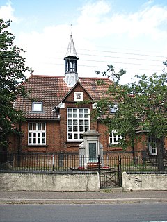
The village has no shops, with the post office now shut. The Methodist chapel has been converted into holiday homes, but the Church of The Ascension still stands. It was built in 1867 when a former church on the site was destroyed by fire. The new church was designed by the architect E. Christian.

Braunston is a village and civil parish in West Northamptonshire, England, next to the border with Warwickshire. At the 2011 Census, the parish had a population of 1,759. Braunston is situated just off the A45 main road and lies between the towns of Daventry and Rugby.

Rostrevor is a village and townland in County Down, Northern Ireland. It lies at the foot of Slieve Martin on the coast of Carlingford Lough, near Warrenpoint. The Kilbroney River flows through the village and Rostrevor Forest is nearby. It is within Newry, Mourne and Down District.
Melton Constable is a village and civil parish in the English county of Norfolk. It covers an area of 6.96 km2 (2.69 sq mi) and had a population of 518 in 225 households at the 2001 census. The population had increased to 618 at the 2011 Census. For the purposes of local government, it falls within the district of North Norfolk. The village sits on fairly high ground southwest of Holt.

Rosscarbery is a town in County Cork, Ireland. The town is on a shallow estuary, which opens onto Rosscarbery Bay. Rosscarbery is in the Cork South-West constituency, which has three seats.
Farnley is a district in Leeds, West Yorkshire, England, 2 miles (3.2 km) south-west of Leeds city centre, between Wortley, Bramley and the countryside around Pudsey and Gildersome, in the LS12 Leeds postcode area. It is part of the Leeds City Ward Farnley and Wortley with a population of 24,213 according to the 2011 Census. New Farnley is a nearby commuter village.

Melton is a village in Suffolk, England, located approximately one mile north east of Woodbridge. The 2001 census recorded a population of 3,718, the population increasing to 3,741 at the 2011 Census. The village is served by Melton railway station on the Ipswich-Lowestoft East Suffolk Line. The parish contains 'Woodbridge' Melton, an area of building contiguous with Woodbridge but separated from most of Melton by the wood, 'Village' Melton, centred around the A1152 and A1438, Melton Park or Melton St Audry's, a housing estate converted from an asylum, and various outlying hamlets.

Barnetby railway station serves the village of Barnetby-le-Wold in North Lincolnshire, England. It is operated by TransPennine Express, with East Midlands Railway and Northern Trains also serving the station.
Wymondham is a village in the Borough of Melton in Leicestershire, England. It is part of a civil parish which also covers the nearby hamlet of Edmondthorpe. The parish has a population of 623, increasing to 632 at the 2011 census. It is close to the county boundaries with Lincolnshire and Rutland, nearby places being Garthorpe, Teigh and South Witham.
Barnetby le Wold is a small rural village and civil parish in North Lincolnshire, England, located between Brigg and Immingham. The village is also not far from the market town of Barton-upon-Humber. The population of the parish in the 2001 census was 1,593. This increased by 148 to 1,741 in the 2011 census.

Bigby is a village and civil parish in the West Lindsey district of Lincolnshire, England.

Naburn is a small village and civil parish in the unitary authority of the City of York in North Yorkshire, England. It lies on the eastern side of the River Ouse about 4 miles (6.4 km) south of York. According to the 2001 census the parish had a population of 470, increasing to 516 at the 2011 census.

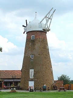
Friston is a village and civil parish in the East Suffolk district, in the county of Suffolk, England. It is 3 miles (5 km) southeast of Saxmundham, its post town, and 4 miles (6 km) northwest of Aldeburgh. The River Alde bounds the village on the south. The surrounding land is chiefly arable. The soil becomes partly marshy in the lower grounds. The village is noted for its early nineteenth century post mill. It is located next to the village of Knodishall.

Briston is a village, civil parish and electoral ward in the English county of Norfolk that contains the hamlet of Briston Common. The village is 11 miles (18 km) east north east of the town of Fakenham, 13.3 miles (21.4 km) west south west of Cromer, 20.3 miles (32.7 km) north north west of the city of Norwich, and 125 miles (201 km) north north east of London. The nearest railway station is at Sheringham for the Bittern Line which runs between Sheringham, Cromer and Norwich but a steam line is also available from Holt to Sheringham. The nearest airport is Norwich International Airport. The civil parish had in 2001 census, a population of 2,021, increasing to 2,439 at the 2011 Census. For the purposes of local government, the parish falls within the district of North Norfolk. The village is situated on the route of the B1354 that runs between the A148 at Thursford and the B1149 at Saxthorpe.
Riseley is a village and civil parish located in North Bedfordshire, England. The village name has had alternative spellings in the past such as Rislau, Riseleg, Riselai and Risely, however all these spellings are considered archaic. It has a population of 1,284 according to the 2001 census, increasing to 1,286 at the 2011 Census, and is near the villages of Bletsoe, Sharnbrook, Swineshead, Pertenhall, Keysoe, Thurleigh and Melchbourne. The nearest town to Riseley is Rushden in the neighbouring county of Northamptonshire, approximately 8 miles away to the north west. The county town of Bedford is approximately 9 miles to the South of Riseley. The village has one watercourse, which is a tributary of the River Ouse, flowing through it known locally as the 'Brook' around which in medieval times the village was built.

Wrawby is a village in North Lincolnshire, England. It lies 2 miles (3 km) east of Brigg and close to Humberside Airport, on the A18. The 2001 Census recorded a village population of 1,293, in around 600 homes, which increased to 1,469 at the 2011 census. Wrawby is noted for England's only remaining postmill.
Stathern is an English village and civil parish in the Melton district of Leicestershire. It lies in the Vale of Belvoir about 10 miles (16 km) north of Melton Mowbray. Its church has an unusual dedication and its school a long history. Its pub doubles as a post office.

Clavet is a village in the Canadian province of Saskatchewan within the Rural Municipality of Blucher No. 343 and Census Division No. 11. The village is located along an old section of the Yellowhead Highway, about 15 kilometres southeast of the City of Saskatoon.

Stoke Ferry is a village and civil parish in the English county of Norfolk, 6.5 miles south-east of Downham Market. The village lies on the River Wissey, previously known as the River Stoke. It covers an area of 9.15 km2 (3.53 sq mi) and had a population of 896 in 358 households as of the 2001 UK Census, the population increasing to 1,020 at the 2011 UK Census. For the purposes of local government, it falls within the district of King's Lynn and West Norfolk.
Currow is a rural village in County Kerry in south west Ireland, located approximately 12 km from Killarney and 18 km from Tralee. Currow is situated on the Brown Flesk River, a tributary of the River Maine.
Normanton-on-the-Wolds is a small village in Nottinghamshire, England. Population in 2011 was 245. Acreage 1053.
| Wikimedia Commons has media related to Melton Ross . |