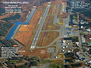
Kenai Municipal Airport is a city-owned, public-use airport located in Kenai, a city in the Kenai Peninsula Borough of the U.S. state of Alaska.
Tunica Municipal Airport is a public use airport located one nautical mile (2 km) east of the central business district of Tunica, in Tunica County, Mississippi, United States. It is owned by the Tunica County Airport Commission. Also known as Tunica Airport, it should not be confused with the 10 acre privately owned, public use Tunica Airport located 2 nautical miles (4 km) south of the center of town, which has been recently changed to Ralph M Sharpe Airport.

Hermiston Municipal Airport is a city-owned, public-use airport located two nautical miles (3.7 km) southeast of the central business district of Hermiston, in Umatilla County, Oregon, United States.
Elkhart Municipal Airport is a city-owned public-use airport located three nautical miles (6 km) northwest of the central business district of Elkhart, a city in Elkhart County, Indiana, United States.
Fernandina Beach Municipal Airport is a city-owned public-use airport located on Amelia Island three nautical miles (6 km) south of the central business district of Fernandina Beach, a city in Nassau County, Florida, United States. It is designated as a reliever airport for Jacksonville International Airport.
West Memphis Municipal Airport is a city-owned public-use airport located three miles (5 km) west of the central business district of West Memphis, in Crittenden County, Arkansas, United States. The airport is 10 nmi (19 km) southwest of General DeWitt Spain Airport in Memphis, Tennessee.

Abbeville Municipal Airport is a city-owned, public-use airport located three nautical miles north of the central business district of Abbeville, a city in Henry County, Alabama, United States. It is the only airport that serves the city of Abbeville.

Wetumpka Municipal Airport is a city-owned, public-use airport located six nautical miles west of the central business district of Wetumpka, a city in Elmore County, Alabama, United States. It is included in the FAA's National Plan of Integrated Airport Systems for 2011–2015, which categorized it as a general aviation facility. During World War II the airport, known then as Elmore Auxiliary Field, served as an auxiliary field for Gunter Army Airfield training operations. In 2013 the airport was listed in the Alabama Register of Landmarks and Heritage.

Grove Hill Municipal Airport was a city-owned public-use airport located two nautical miles southeast of the central business district of Grove Hill, a city in Clarke County, Alabama, United States. According to the FAA's National Plan of Integrated Airport Systems for 2009–2013, it was categorized as a general aviation facility. The airport has been permanently closed.

Headland Municipal Airport is a city-owned, public-use airport located two nautical miles northeast of the central business district of Headland, a city in Henry County, Alabama, United States.

Lanett Municipal Airport is a city-owned public-use airport located three nautical miles southwest of the central business district of Lanett, a city in Chambers County, Alabama, United States. According to the FAA's National Plan of Integrated Airport Systems for 2009–2013, it is categorized as a general aviation facility.

Scottsboro Municipal Airport, also known as Word Field, is a city-owned public-use airport located two nautical miles (3.7 km) northeast of the central business district of Scottsboro, a city in Jackson County, Alabama, United States. According to the FAA's National Plan of Integrated Airport Systems for 2009–2013, it is categorized as a general aviation facility.
Deer Park Airport, formerly known as Deer Park Municipal Airport, is a city-owned public-use airport located three nautical miles (6 km) northeast of the central business district of Deer Park, a city in Spokane County, Washington, United States.
Fairmont Municipal Airport is a city-owned public-use airport located two nautical miles (3.7 km) southeast of the central business district of Fairmont, a city in Martin County, Minnesota, United States.
New Castle Municipal Airport is a small municipal airport located in Union Township, Lawrence County, Pennsylvania serving Lawrence County, Pennsylvania, part of the Pittsburgh metropolitan area. Union Township is an outskirt of New Castle, Pennsylvania hence the name. The airport is located four nautical miles northwest of the central business district of New Castle. The airport is a public-owned airport and is controlled by the Lawrence County Airport Authority.
Red Oak Municipal Airport is a city-owned public-use airport located two nautical miles (3.7 km) west of the central business district of Red Oak, a city in Montgomery County, Iowa, United States. According to the FAA's National Plan of Integrated Airport Systems for 2009–2013, it is categorized as a general aviation facility.
Mount Pleasant Municipal Airport is a city-owned public-use airport located three nautical miles southeast of the central business district of Mount Pleasant, a city in Henry County, Iowa, United States. According to the FAA's National Plan of Integrated Airport Systems for 2009–2013, it is categorized as a general aviation facility.
Jackson Municipal Airport is a city-owned public-use airport located two nautical miles north of the central business district of Jackson, a city in Jackson County, Minnesota, United States. It is included in the FAA's National Plan of Integrated Airport Systems for 2011–2015, which categorized it as a general aviation facility.
Eutaw Municipal Airport is a city-owned, public-use airport located two nautical miles southeast of the central business district of Eutaw, a city in Greene County, Alabama, United States. As of 8 December 2017, the airport is indefinitely closed.
Denison Municipal Airport is a city-owned, public-use airport located two nautical miles (4 km) southwest of the central business district of Denison, a city in Crawford County, Iowa, United States. It is included in the National Plan of Integrated Airport Systems for 2011–2015, which categorized it as a general aviation facility.
