Campbelltown is a suburb located on the outskirts of the metropolitan area of Sydney, New South Wales, Australia. It is located in Greater Western Sydney 53 kilometres (33 mi) south-west of the Sydney central business district by road. Campbelltown is the administrative seat of the local government area of the City of Campbelltown. It is also acknowledged on the register of the Geographical Names Board of New South Wales as one of only four cities within the Sydney metropolitan area.

Camden is a historic town and suburb of Sydney, New South Wales, located 65 kilometres south-west of the Sydney central business district. Camden was the administrative centre for the local government area of Camden Council until July 2016 and is a part of the Macarthur region.

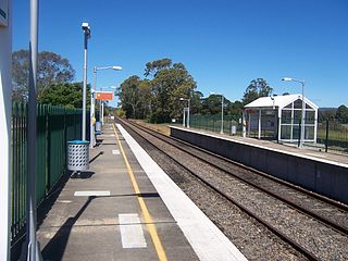
Campbelltown railway station is a heritage-listed railway station located on the Main Southern line, serving the Sydney suburb of Campbelltown. It is served by Sydney Trains' T8 Airport & South line services and NSW TrainLink services to Moss Vale, Goulburn, Canberra, Griffith and Melbourne.
Menangle Park is a suburb in Sydney the state of New South Wales, Australia. Menangle Park is located 56 kilometres south-west of the Sydney central business district, in the local government area of the City of Campbelltown. Menangle Park is a largely rural area and is part of the Macarthur region.
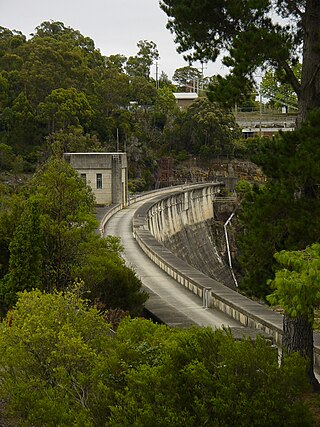
The Nepean Dam is a heritage-listed dam split across Avon in the Wingecarribee Shire and Bargo in the Wollondilly Shire, both in New South Wales, Australia. The reservoir created by the dam spreads across Avon, Bargo and also Yerrinbool in Wingecarribee Shire. The Nepean Dam is one of four dams and weirs in the catchment of the Upper Nepean Scheme, in New South Wales, Australia, and provides water to the Macarthur and Illawarra regions, the Wollondilly Shire, and metropolitan Sydney. Completed in 1935 under the supervision of Ernest Macartney de Burgh, the dam is currently managed by the Sydney Catchment Authority and is listed on the New South Wales State Heritage Register.

Macarthur is a region in the south-west part of the Greater Sydney area, in the state of New South Wales, Australia. The region includes the local government areas of the City of Campbelltown, Camden Council, and Wollondilly Shire. It covers an area of 3,067 square kilometres and has a population of close to 310,000 residents. The region geographically forms the foothills between the Blue Mountains and Southern Highlands regions.

Wollondilly Shire is a periurban local government area, located on the south west fringe of the Greater Sydney area in New South Wales, Australia, parts of which fall into the Macarthur, Blue Mountains and Central Tablelands regions in the state of New South Wales, Australia. Wollondilly is seen as the transition between Regional NSW and the Greater Sydney Region, and is variously categorised as part of both. Wollondilly Shire was created by proclamation in the NSW Government Gazette on 7 March 1906, following the passing of the Local Government (Shires) Act 1905, and amalgamated with the Municipality of Picton on 1 May 1940.

The Victoria Bridge, also known as the Victoria Bridge over the Nepean River, is a heritage-listed former railway bridge and now wrought iron box plate girder road bridge across the Nepean River on the Great Western Highway in the western Sydney suburb of Penrith in the City of Penrith local government area of New South Wales, Australia. The bridge was designed by John Whitton, the Engineer–in–Chief of New South Wales Government Railways, and built from 1862 to 1867 by William Piper, Peto Brassey and Betts (superstructure), William Watkins (piers). It is also known as Victoria Bridge, The Nepean Bridge and RTA Bridge No. 333. It was added to the New South Wales State Heritage Register on 27 May 2016.

The Main Southern Railway is a major railway in New South Wales, Australia. It runs from Sydney to Albury, near the Victorian border. The line passes through the Southern Highlands, Southern Tablelands, South West Slopes and Riverina regions.

The Camden Park Estate incorporating the Belgenny Farm is a heritage-listed large working historical farm located at Elizabeth Macarthur Avenue, in the outer south-western Sydney suburb of Camden South, New South Wales, Australia. It was designed by Henry Kitchen in c. 1800, John Verge in c. 1835 and A. J. Onslow in c. 1888 and built from 1819 to 1840 by John Macarthur in c. 1800, James English and Sons in c. 1888 and John Sulman c. 1895. The property is owned by Belgenny Farm Trust and Camden Park Preservation Committee. It was added to the New South Wales State Heritage Register on 22 December 2006. Today, part of the original estate contains the Elizabeth Macarthur Agricultural Institute; having originally served as a commercial sheep station and horticultural farm for the Macarthur family since the early 1800s.

Maldon is a locality in the Macarthur Region of New South Wales, Australia, in the Wollondilly Shire. In the 2016 census it had a population of 15.

The Nepean River railway bridge is a heritage-listed railway bridge that carries the Main Southern railway line across Menangle Road and the Nepean River located at the outer south-western Sydney settlement of Menangle in the Wollondilly Shire local government area of New South Wales, Australia. It was designed by John Whitton as the Engineer-in-Chief, of the New South Wales Government Railways and NSW Department of Public Works. The railway bridge was built in 1863 by Messers Peto, Brassey and Betts. It is also known as Menangle rail bridge over Nepean River and Menangle Railway Bridge. The property was added to the New South Wales State Heritage Register on 2 April 1999.

The Macquarie River railway bridge is a heritage-listed disused railway bridge across the Macquarie River that was previously located on the Main Western line in Bathurst in the Bathurst Region local government area of New South Wales, Australia. It was built in 1876. It is also known as Bathurst Rail Bridge over Macquarie River and Bathurst – Kelso Railway Bridge. The property is owned by Transport Asset Holding Entity, an agency of the Government of New South Wales. The bridge was added to the New South Wales State Heritage Register on 2 April 1999 and was added to the Register of the National Estate on 18 April 1989.

The Dubbo rail bridge over Macquarie River – Wambuul is a heritage-listed railway bridge on the Main Western line across the Macquarie River, located west of the Dubbo central business district in New South Wales, Australia. It was designed by John Whitton as the Engineer-in-Chief for the New South Wales Government Railways. The bridge was built during 1884 by Benjamin Barnes, with ironwork by Cochrane & Co, Middlesborough, England. The railway bridge is also known as the Dubbo Lattice Railway Bridge. The property is owned by Transport Asset Holding Entity, an agency of the Government of New South Wales. The bridge was added to the New South Wales State Heritage Register on 2 April 1999 and was listed on the Register of the National Estate on 18 April 1989.
The Goulburn Viaduct is a heritage-listed railway bridge that carries the Main Southern railway line across the Mulwaree River at Goulburn, in the Goulburn Mulwaree Council local government area of New South Wales, Australia. It was built in 1915. It is also known as Mulwaree River Railway Viaduct. The property is owned by Transport Asset Holding Entity, an agency of the Government of New South Wales. It was added to the New South Wales State Heritage Register on 2 April 1999.

The Long Cove Creek railway viaducts are heritage-listed railway viaducts which carry the Main Suburban railway line over Long Cove Creek between the suburbs of Lewisham and Summer Hill in Sydney, New South Wales, Australia. The viaducts were designed and built by the New South Wales Government Railways. The property is owned by Transport Asset Holding Entity, an agency of the Government of New South Wales. It was added to the New South Wales State Heritage Register on 2 April 1999.

Stonequarry Creek railway viaduct is a heritage-listed railway viaduct over the Stonequarry Creek located on the Main Southern railway in the south-western Sydney town of Picton in the Wollondilly Shire local government area of New South Wales, Australia. It was designed by John Whitton as the Engineer-in-Chief for Railways and was built from 1863 to 1867 by Murnin and Brown. It is also known as Stonequarry Creek Railway Viaduct and Picton railway viaduct over Stonequarry Creek. The property is owned by Transport Asset Holding Entity, an agency of the Government of New South Wales. It was added to the New South Wales State Heritage Register on 2 April 1999.

The Lithgow Underbridge is a heritage-listed railway underbridge that carries the Main West Line over James Street, in Lithgow, in the City of Lithgow local government area of New South Wales, Australia. The bridge is located approximately 156 kilometres (97 mi) from Central railway station. The bridge was designed by John Whitton as the Engineer-in-Chief for Railways and was built in 1869 by contractor, P. Higgins. It is also known as Lithgow Underbridge. The property is owned by Transport Asset Holding Entity, an agency of the Government of New South Wales. It was added to the New South Wales State Heritage Register on 30 August 2013.

Emu Plains Underbridge is a heritage-listed steel truss railway underbridge located off Bruce Neale Dr approximately 1.3 kilometres (0.81 mi) west of the Penrith railway station in the western Sydney suburb of Penrith in the City of Penrith local government area of New South Wales, Australia. It was designed by James Fraser, the existing lines branch and the New South Wales Government Railways. It was built in 1907, with fabrication by R. Tulloch & Co.; and erection by day labour. It is also known as Emu Plains Underbridge and Penrith Underbridge. The property is owned by Transport Asset Holding Entity, an agency of the Government of New South Wales. It was added to the New South Wales State Heritage Register on 28 June 2013.

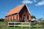
St John's Anglican Church Precinct, also known as St John's Camden, is a heritage-listed Anglican church and associated precinct at 6-22 Menangle Road, Camden, Camden Council, New South Wales, Australia. The precinct comprises the church, rectory, cemetery, two church halls and grounds that provide a rural landscaped environment to the group. The dominant feature of the precinct is the historic St John's the Evangelist Anglican Church. Its architects are unknown, and could be the cumulative work of Mortimer Lewis, John Cunningham and Edmund Blacket. It was built from 1840 to 1849 with Richard Basden responsible for the nave and John Le Fevre adding the spire. 1874 saw the addition of the chancel and vestry, their builder is unknown and the design is likely the work of Sir George Gilbert Scott and Blacket. A feature of the church is an organ manufactured by J. Bates & Son, London. The Anglican Church Property Trust of the Diocese of Sydney holds the property in trust, under the Anglican Church of Australia Trust Property Act 1917 (NSW). The precinct was added to the New South Wales State Heritage Register on 24 August 2018.