
U.S. Route 80 or U.S. Highway 80 (US 80) is a major east–west United States Numbered Highway in the Southern United States, much of which was once part of the early auto trail known as the Dixie Overland Highway. As the "0" in the route number indicates, it was originally a cross-country route, from the Pacific Ocean to the Atlantic Ocean. Its original western terminus was at Historic US 101 in San Diego, California. However, the entire segment west of Dallas, Texas, has been decommissioned in favor of various Interstate Highways and state highways. Currently, the highway's western terminus is at an interchange with Interstate 30 (I-30) on the Dallas–Mesquite city line. Its eastern terminus is in Tybee Island, Georgia, near the Atlantic Ocean. Between Jonesville, Texas, and Kewanee, Mississippi, US 80 runs parallel to or concurrently with Interstate 20. It also currently runs through Dallas, Texas; Shreveport, Louisiana; Jackson, Mississippi; Montgomery, Alabama; Columbus, Georgia; Macon, Georgia; and Savannah, Georgia.

U.S. Route 75 is a north–south U.S. Highway that runs 1,239 miles (1,994 km) in the central United States. The highway's northern terminus is located at the Canadian border near Noyes, Minnesota, at a now-closed border crossing. From this point, the highway once continued farther north as Manitoba Highway 75. Its southern terminus is located at Interstate 30 (I-30) and Interstate 45 (I-45) in Dallas, Texas, where US 75 is known as North Central Expressway.

U.S. Route 77 is a major north–south United States Numbered Highway which extends for 1,305 miles (2,100 km) in the central United States. As of 2005, Its southern terminus is in Brownsville, Texas, at Veteran's International Bridge on the Mexican border, where it connects with both Mexican Federal Highway 101 and Mexican Federal Highway 180, and the highway's northern terminus is in Sioux City, Iowa, at an interchange with Interstate 29 (I-29), less than 1⁄2 mile (800 m) north of the Nebraska state line.

U.S. Route 81 or U.S. Highway 81 (US 81) is a major north–south U.S. highway that extends for 1,220 miles (1,960 km) in the central United States and is one of the original United States Numbered Highways established in 1926 by the American Association of State Highway Officials.
U.S. Route 183 (US 183) is a north–south United States highway. The highway's northern terminus is in Presho, South Dakota, at an intersection with Interstate 90. Its southern terminus is in Refugio, Texas, at the southern intersection of U.S. Highway 77 and Alternate US 77.

The Santa Fe Trail was a 19th-century route through central North America that connected Franklin, Missouri, with Santa Fe, New Mexico. Pioneered in 1821 by William Becknell, who departed from the Boonslick region along the Missouri River, the trail served as a vital commercial highway until 1880, when the railroad arrived in Santa Fe. Santa Fe was near the end of El Camino Real de Tierra Adentro which carried trade from Mexico City. The trail was later incorporated into parts of the National Old Trails Road and U.S. Route 66.
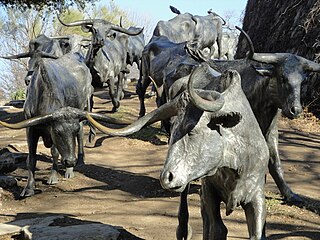
The Texas Road, also known as the Shawnee Trail, or Shawnee-Arbuckle Trail, was a major trade and emigrant route to Texas across Indian Territory. Established during the Mexican War by emigrants rushing to Texas, it remained an important route across Indian Territory until Oklahoma statehood. The Shawnee Trail was the earliest and easternmost route by which Texas Longhorn cattle were taken to the north. It played a significant role in the history of Texas, Oklahoma, Missouri, and Kansas in the early and mid-1800s.

The National Register of Historic Places in the United States is a register including buildings, sites, structures, districts, and objects. The Register automatically includes all National Historic Landmarks as well as all historic areas administered by the U.S. National Park Service. Since its introduction in 1966, more than 97,000 separate listings have been added to the register.

The Great Western Cattle Trail is the name used today for a cattle trail established during the late 19th century for moving beef stock and horses to markets in eastern and northern states. It ran west of and roughly parallel to the better known Chisholm Trail into Kansas, reaching an additional major railhead there for shipping beef to Chicago, or longhorns and horses continuing on further north by trail to stock open-range ranches in the Dakotas, Wyoming, Montana in the United States, and Alberta and Saskatchewan in Canada.

Saskatchewan, the middle of Canada's three prairie provinces, has an area of 588,276.09 square kilometres (227,134.67 sq mi) and population of 1,150,632, mostly living in the southern half of the province.

The Nebraska State Highway System consists of all the state highways in Nebraska maintained by the Nebraska Department of Transportation. This includes federally designated Interstates and US Highways as well as state highways, links and spurs. The system comprises 9,942 miles (16,000 km) of state highways in all 93 counties. Highways within the system range in scale and quality from 10-lane urban freeways, such as I-80 around Omaha, to standard two-lane rural undivided highways as well as 39 miles (63 km) of state highways that remain unpaved such as N-67 north of Dunbar. Surrounding landscapes along the highway system range from the urban areas in Omaha and Lincoln to scenic journeys through uninhabited grasslands in the Nebraska Sandhills.
K-53 is a 6.177-mile-long (9.941 km) state highway in the U.S. state of Kansas. Located entirely within Sumner County, K-53's western terminus is at U.S. Route 81 (US-81) south of Wichita and the eastern terminus is at an interchange with K-15 by Mulvane. Along the way, K-53 intersects Interstate 35 (I-35), also known as the Kansas Turnpike, at exit 33. The highway travels mostly through farmlands with the exception of inside Mulvane and is a two-lane road its entire length.
U.S. Route 75 was a part of the United States Numbered Highway System that runs for 1,239 miles (1,994 km) from Dallas, Texas to Kittson County, Minnesota where it ends just short of the Canada–United States border. Within the State of Nebraska it is a state highway that enters Nebraska on the Kansas state line about 9 miles (14 km) south of Dawson and travels north across the extreme eastern portion of the state, to the Nebraska–Iowa border in South Sioux City where it crosses the Missouri River along a concurrency with Interstate 129. The northern 210 miles (340 km) of the route generally travels parallel to the Missouri River. The 87.32-mile (140.53 km) section between the I-680 interchange in Omaha and the Interstate 129 interchange is designated the Lewis & Clark Scenic Byway, one of nine scenic byways in the state.
U.S. Route 81 (US-81) is a north–south U.S. highway running through the central United States' Great Plains region, from Fort Worth, Texas to the U.S.–Canadian border at Pembina, North Dakota. A 229.28-mile (368.99 km) segment of the highway lies within the state of Oklahoma. US-81 crosses the Red River from Texas south of Terral, passing through several Oklahoma cities, such as Chickasha, El Reno, Kingfisher, and Enid, before entering Kansas north of Renfrow.
Maverick Junction, South Dakota, United States, is an unincorporated community and census-designated place (CDP) located in Fall River County at the intersection of South Dakota Highway 79 and US Highways 18 and 385, approximately five miles southeast of Hot Springs. The population was 46 at the 2020 census.
U.S. Highway 75 (US 75) is a United States Highway in northwestern Iowa. It begins at the Missouri River on a bridge with Interstate 129 (I-129) and US 20. Immediately upon landing in Iowa from Nebraska, I-129 ends at an interchange with I-29. US 20 and US 75 continue around Sioux City on a four-lane expressway until US 20 exits to the east. US 75 heads to the north-northeast, parallel to the Floyd River, until Le Mars. There, Iowa Highway 60 (Iowa 60) continues northeastward on the expressway while US 75 heads due north. Near Hull, it is briefly overlapped by US 18. It leaves the state and enters Minnesota north of Rock Rapids.

K-49 is a 35.354-mile-long (56.897 km) north–south state highway in the U.S. state of Kansas. K-49 begins at U.S. Route 81 (US-81) in Caldwell, and runs north to K-42 in Viola. Along the way, K-49 has a brief overlap with US-160 south of Conway Springs. The majority of the route exists in Sumner County, with only a mile existing in Sedgwick County.

K-92 is an approximately 44-mile-long (71 km) state highway in the U.S. state of Kansas. K-92's western terminus is at K-4 south of the community of Rock Creek, and the eastern terminus is a continuation as Missouri State Route 92 at the Missouri border by the City of Leavenworth. K-92 is co-designated as U.S. Route 59 (US-59) in Oskaloosa, K-16 from Oskaloosa to McLouth, and K-7 and US-73 in Leavenworth. The majority of the route passes through rural farmland and is almost entirely a two-lane roadway, except for the overlap with K-7 and US-73 and a portion of the US-59 overlap, which are four-lane.
K-87 is a 8.625-mile-long (13.881 km) north–south state highway in the U.S. state of Kansas. The highway runs from the end of state maintenance, where it continues as 26th Road, in the community of Vliets north to U.S. Route 36 (US 36) west of the community of Baileyville. The highway travels through farmlamd and is a two-lane highway its entire length.

K-106 is an approximately 16+1⁄4-mile-long (26.2 km) state highway in the U.S. state of Kansas. It is signed as a west–east route even though the first approximately 6.5 miles (10.5 km) runs directly south to north. K-106's western terminus is at K-18 north-northwest of Salina, and the eastern terminus is a continuation as Lake Drive at Ottawa State Fishing Lake. About midway along the route, K-106 serves the city of Minneapolis and intersects U.S. Route 81 (US-81) just west of the city. South of Minneapolis, the highway passes within one mile (1.6 km) of Rock City, a group of 200 spherical boulders designated as a National Natural Landmark.


