Merlin, Ontario

Last updated
Merlin
Unincorporated community
Merlin ON.JPG
Chatham-Kent locator map 2021.svg
Red pog.svg
Merlin
Canada Southern Ontario location map 2.png
Red pog.svg
Merlin
Coordinates: 42°14′28″N82°13′50″W / 42.24111°N 82.23056°W / 42.24111; -82.23056
CountryFlag of Canada (Pantone).svg  Canada
Province Flag of Ontario.svg  Ontario
Municipality Chatham-Kent
Time zone UTC-5 (EST)
  Summer (DST) UTC-4 (EDT)
Forward sortation area
Area code(s) 519 and 226
NTS Map040J01
GNBC CodeFEBSL

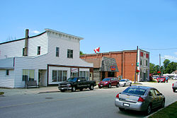
Merlin is a small farming community inhabited by 750 residents located in Southwestern Ontario, Canada. It lies five kilometres due north off the shores of Lake Erie in the municipality of Chatham-Kent. Merlin's name was bestowed upon it by Post Office Department in 1868 after a village near Edinburgh, Scotland. [1] The town has three main streets branching out from the main intersection. Erie Street (Merlin Town Line) runs north and south through the centre of town. William Street begins at the main intersection and travels west toward the town of Tilbury while Aberdeen Street travels east from the main intersection toward the hamlet of South Buxton. Merlin is the hometown of country music singer Michelle Wright.

Contents

Facilities

The town was once home to both a high school and elementary school. However, after enrolment fell below 100 students, Merlin District High School, located on William Street and home to the Merlin Mustangs, closed around 1980 and was subsequently torn down. Merlin Area Public School, home of the Merlin Colts, still operates at the northern edge of town, on Erie Street. [2] The school opened in 1968 and has a present enrolment of approximately 250 students. The Merlin Library is located on Aberdeen Street, and has books, internet access, and resource sharing agreements with other public libraries throughout Chatham-Kent. [3]

Merlin had an Ontario Provincial Police detachment located at Blake and Erie Street South (now Merlin Road) but the police station was closed in the 1990s. The building is now occupied by the Chatham-Kent Fire Department.

The Kinsmen, who have a charter in Merlin, [4] maintain the Merlin Kinsmen Park, which has a playground, splash pad, shelters and two baseball diamonds. A community centre and another baseball diamond are located on the east side of the town and are maintained by the municipality of Chatham-Kent. Adjacent to the park, there is a cenotaph commemorating Canadian participants in World War II. Merlin is also home to the Royal Canadian Legion, Branch 465.

For local amenities, Merlin has three eateries—Erie Café & Variety, The Garage, and Flame & Frostbite—two general stores, and a branch of Canada Post. Merlin is also Home to the Summer's Gold Honey Company, Chatham-Kent's only CFIA registered Honey packing facility. Summer's Gold Honey Company offers both wholesale and retail honey and hive products including but not limited to Honey, beeswax, candles, soap and lip balm. Tours of the facility are available upon advance request.

There is a reputedly haunted house in Merlin. The residence is featured in a yearly local "Ghost Walks of Chatham". [5]

Industries

The town of Merlin, and the adjacent townships of Tilbury East on its west side, and Raleigh to its east (no longer officially townships since the formation of the municipality of Chatham-Kent in 1998) maintain farming as the primary industry. A significant alteration to the local landscape started in 2007 with the construction of 44 wind turbines by Kruger Energy. The wind turbines were constructed in Denmark and are each capable of generating 2.3 megawatts (MW) (total 101.2 MW) of electricity. [6]

Natural gas wells were once part of the area to the west, in the former Tilbury East township, with the raw gas going to a Union Gas pumping station at Port Alma. With the capping of the wells and the closing of the pumping station in the 1980s, Union Gas sold the facilities and the main pumping building is no longer in Port Alma, but some maintenance sheds and an office building still remain.

Related Research Articles

Essex County, Ontario County in Ontario, Canada

Essex County is a primarily rural county in Southwestern Ontario, Canada comprising seven municipalities: Amherstburg, Kingsville, Lakeshore, LaSalle, Leamington, Tecumseh and the administrative seat, Essex. Canada's southernmost county, Essex had a population of 181,530 as of the 2016 census.

Chatham-Kent Municipality in Ontario, Canada

Chatham-Kent is a single-tier municipality in Southwestern Ontario, Canada. Mostly rural, its population centres are Chatham, Wallaceburg, Tilbury, Blenheim, Ridgetown, Wheatley and Dresden. The current Municipality of Chatham-Kent was created in 1998 by the amalgamation of Blenheim, Bothwell, Camden, city of Chatham, township of Chatham, Dover, Dresden, Erie Beach, Erieau, Harwich, Highgate, Howard, Orford, Raleigh, Ridgetown, Rodney, Thamesville, Tilbury East, Tilbury, Wallaceburg, Wheatley and Zone.

Lakeshore, Ontario Municipality in Ontario, Canada

Lakeshore is a Municipality on Lake St. Clair, in Essex County, Ontario, Canada. The Municipality was incorporated in 1999 by amalgamating the Town of Belle River with the townships of Maidstone, Rochester, Tilbury North, and Tilbury West. It is the largest and the most populous municipality within Essex County. However, it is part of the Windsor census metropolitan area.

Kent County, Ontario Former County in Ontario, Canada

Kent County, area 2,458 km2 is a historic county in the Canadian province of Ontario.

Kent—Essex was a federal electoral district (riding) in Ontario, Canada, that was represented in the House of Commons of Canada from 1968 to 1979.

Essex (electoral district) Federal electoral district in Ontario, Canada

Essex is a federal electoral district in Ontario, Canada, represented in the House of Commons of Canada from 1867 to 1882 and since 1968.

Kent was a federal electoral district (riding) represented in the House of Commons of Canada from 1867 to 1904, 1917 to 1968, and 1979 to 1997. It was located in the province of Ontario, and was created by the British North America Act of 1867.

Kent West was a federal electoral district represented in the House of Commons of Canada from 1904 to 1917. It was located in the province of Ontario. This riding was created in 1903 when Kent riding was divided into two ridings, Kent West and Kent East.

Tilbury, Ontario Unincorporated community in Ontario, Canada

Tilbury is a community within the municipality of Chatham-Kent, Ontario, Canada. It is located 26.5 kilometres (16.5 mi) southwest of Chatham-Kent and 57.3 kilometres (35.6 mi) east of Windsor on Highway 401.

Essex—Kent was a federal electoral district in Ontario that was represented in the House of Commons of Canada from 1979 to 1997.

Ridgetown is a community located in south-east Chatham-Kent, Ontario, Canada. It is home to the University of Guelph Ridgetown Campus. It has a 2021 population of 2,797 and is one of many small farming communities in Chatham-Kent. The town motto is, "Agriculture at its best”.

Wheatley, Ontario Unincorporated community in Ontario, Canada

Wheatley is a community in Southwestern Ontario, Canada, within the municipality of Chatham-Kent. It lies about 12 kilometres (7 mi) east of Leamington. Nearby parks include Two Creeks Conservation Area, which has 15 km of hiking and bicycling paths, Kopegaron Woods Conservation Area, Hillman Marsh Conservation Area and Point Pelee National Park. Rondeau Provincial Park is only a forty-five-minute drive to the east. It also boasts Wheatley Provincial Park, home to the endangered Blue Racer snake, which can only be found in the park as well as the Point Pelee National Park and on Pelee Island.

Lambton Kent District School Board

The Lambton Kent District School Board is the school board responsible for public education in Lambton County and Kent County. Lambton and Kent Counties are made up of numerous small towns and communities situated in Southwestern Ontario, a geographic area surrounded by the Great Lakes. The board serves over 21,000 elementary and high school students. Surrounding towns and communities include Wheatley, Tilbury, Merlin, Blenheim, Chatham, Ridgetown, Thamesville, Dresden, Wallaceburg, Bothwell, Mooretown, Corunna, Sarnia, Brigden, Petrolia, Alvinston, Point Edward, Wyoming, Watford, Forest, Grand Bend, and Wyoming.

Blenheim is a community located in south-central Chatham-Kent, Ontario, Canada.

Ontario Highway 77 Ontario provincial highway

King's Highway 77, commonly referred to as Highway 77, is a provincially maintained highway in the Canadian province of Ontario. One of three highways within Essex County, Highway 77 serves to interconnect Highway 3 near Leamington with Highway 401 near Tilbury. Prior to 1998, the highway extended south into Leamington, ending at the former routing of Highway 3 and Highway 18. This section was turned over to Essex County and renamed Erie Street. The speed limit on Highway 77 is 80 km/h (50 mph) in most places, dropping to 50 km/h in built-up areas. It is patrolled by the Ontario Provincial Police.

King's Highway 98, commonly referred to as Highway 98, was a provincially maintained highway in the Canadian province of Ontario, designated as part of the provincial highway system between 1939 to 1971. The route travelled through the northern part of Essex County and through south-central Chatham-Kent, extending 96.3 kilometres (59.8 mi) from Windsor to Blenheim.

CK Transit provides the conventional bus transportation in Chatham-Kent, Ontario, Canada.

King's Highway 78, commonly referred to as Highway 78, was a provincially maintained highway in the Canadian province of Ontario. The 17.60-kilometre (10.94 mi) route connected Highway 40 in downtown Wallaceburg with Highway 21 in Dresden.

Entegrus Powerlines is an electric distributor located in southwestern Ontario, Canada. The utility provides electrical supply to approximately 40,000 customers. Its service territory covers 96 square kilometres of urban areas, encompassed within a 5,000 square kilometre geographic area between Windsor, London and Sarnia. The Entegrus Powerlines service territory is more specifically described as encompassing the following:

References

  1. Hamilton, William (1978). The Macmillan Book of Canadian Place Names . Toronto: Macmillan. pp.  158. ISBN   0-7715-9754-1.
  2. Merlin Area Public School. Ministry of Education.
  3. "Chatham-Kent Public Library- Site: Merlin - Aberdeen St Service: Library Services - Merlin Branch". 211 South-West Ontario Community Services Database. Retrieved August 23, 2019.
  4. "Zone G Home". Kin Canada. Retrieved August 23, 2019.
  5. "Ghost Walks - Tourism - Chatham-Kent". www.chatham-kent.ca. Archived from the original on 2020-08-14.
  6. "Kruger Energy, Chatham Wind Project Merlin, Ontario" (PDF). www.blackandmcdonald.com (pdf). Black and McDonald. Retrieved August 23, 2019.

Coordinates: 42°14′28″N82°13′50″W / 42.24111°N 82.23056°W / 42.24111; -82.23056