Mers El Hadjadj

Last updated
Mers El Hadjadj
مرسى الحجاج
Commune and town
Marsat el Hadjadj.JPG
Marsat el Hadjadj.
CountryFlag of Algeria.svg  Algeria
Province Mascara Province
District Bethioua District
Population
 (1998)
  Total14,167
  Density730/sq mi (282/km2)
Time zone UTC+1 (CET)

Mers El Hadjadj is a town and commune in mascara Province, Algeria. According to the 1998 census it has a population of 14,167. [1]

Contents

Environment

Mars El Hadjadj is located at the extreme east of the Oran wilaya, between the towns of Bethioua in the east and Fornaka (wilaya of Mostaganem). It lies in the Gulf of Arzew, with a harbor protected by two rocky capes.

Dunes

Macta dunes 1975. Macta dunes 1975.jpg
Macta dunes 1975.

The area of coastal dunes is limited: to the north by the sea; To the east by the cliff and hill of the marabout of Sidi Mansour; To the south by the national road from Oran to Mostaganem to the bridge of the Macta, then by the river La Macta; To the west by the mouth of this river "(Simonneau and Santa, 1951). This mouth has since been clogged and a new junction with the sea was made through the dune cordon near the bridge of La Macta.

"The area of this area is about 180 ha. The vegetation is characterized mainly by the size of the stands of the Ocrea on the coastal dunes and by the extreme variety of the flora on the right bank of the river La Macta. The halophilic and heliophilic species grow there with the littoral species "(Simonneau and Santa, 1951). As the authors have already pointed out, the forest horizon is severely degraded east of these dunes (sparse, mutilated, ...). In October 1983, scientists from the National Agronomic Institute (Algeria), the universities of Liège, Gembloux (Belgium), Nijmegen (Holland), and the Royal Institute of Natural Sciences of Belgium contacted, The Algerian authorities (in particular the Wali of the Wilaya of Mostaganem).

Name

Called "Port of the Pilgrims" by the Algerians, it is possible that the French name of "Port aux Poules" comes from an erroneous translation due to the phonetic and graphic similarity in Arabic of the words "pilgrims" (ألحجاج), "al-hajāj" and "chickens" (الدجاج) "ad-dajāj". Another hypothesis is an allusion to chickens frequenting the Macta River, behind the dunes of Marsat El Hadjadj. As a third hypothesis, it could simply come from the Roman name of the ancient port which occupied the gulf, whose name was Paulus, named after a high dignitary of the Roman Empire.

History

Modern History

After the decree of the National Assembly of 19 September 1848 establishing agricultural colonies in Algeria, the convoy of volunteers No. 2 arriving at Arzew on 2 November 1848 was destined for the center of Saint Leu and its annexes, of which Port To the Chickens.

When in 1853, the agricultural colony of Saint Leu passes under civil administration, Port aux Poules is still attached to it.

In 1854, the prefect of Oran commissioned the study of the establishment of a population center in the place called Porto Paulo, near the Macta bridge. The site already had a few European families, was a staging and bivouac place used by the military, was frequented by many fishermen and was already an active and attractive shopping center.

The project was finally adopted in 1877, but it will take time to materialize on the ground.

In 1879, Saint Leu was erected as a full-function commune, but Port aux Poules remained attached to it. Later from the 1930s, most of the inhabitants of the neighboring village of Bethioua settled in Port aux Choules because of the development of oil refineries along the beach. It was a very ancient dwelling site, of which many Roman ruins are still in excellent state of conservation. The region of Bethioua is known for its population of Berber origin which bears the name of the place.

The official construction of the village according to the well-ordered rectangular plans of the time dates back to 1883, but will soon overflow its original framework.

Related Research Articles

<span class="mw-page-title-main">Mostaganem Province</span> Province of Algeria

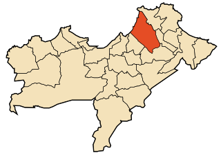
Mostaganem is a province (wilaya) of Algeria. Its capital is Mostaganem.

<span class="mw-page-title-main">Transport in Algeria</span> Algerias transportation systems

As the tenth-largest country in the world, and the largest in Africa and in the Mediterranean region, Algeria has a vast transportation system that includes a large and diverse transportation infrastructure.

<span class="mw-page-title-main">Oran</span> City in Oran Province, Algeria

Oran is a major coastal city located in the north-west of Algeria. It is considered the second most important city of Algeria after the capital Algiers, due to its population and commercial, industrial, and cultural importance. It is 432 km (268 mi) west-south-west from Algiers. The total population of the city was 803,329 in 2008, while the metropolitan area has a population of approximately 1,500,000 making it the second-largest city in Algeria.

Articles related to Algeria include:

<span class="mw-page-title-main">Mostaganem</span> City in Mostaganem Province, Algeria

Mostaganem is a port city in and capital of Mostaganem province, in the northwest of Algeria. The city, founded in the 11th century lies on the Gulf of Arzew, Mediterranean Sea and is 72 km ENE of Oran. It is considered as the second-largest city in the country's northwest, after Oran, and as Algeria's fourth-largest port city with its 457,986 inhabitants as of the 2018 census.

<span class="mw-page-title-main">Arzew</span> Municipality in Oran, Algeria

Arzew or Arzeu is a port city in Algeria, 25 miles (40 km) from Oran. It is the capital of Arzew District, Oran Province.

<span class="mw-page-title-main">Tiaret</span> City in Tiaret Province, Algeria

Tiaret is a major city in northwestern Algeria that gives its name to the wider farming region of Tiaret Province. Both the town and region lie south-west of the capital of Algiers in the western region of the Hautes Plaines, in the Tell Atlas, and about 150 km (93 mi) from the Mediterranean coast. It is served by Abdelhafid Boussouf Bou Chekif Airport.

<span class="mw-page-title-main">Oran Province</span> Province of Algeria

Oran Province is a province (wilayah) in Algeria whose seat is the city of the same name.

<span class="mw-page-title-main">Ténès</span> Place in Chlef Province, Algeria

Ténès is a town in Algeria located around 200 kilometers west of the capital Algiers. As of 2000, it has a population of 65,000 people.

<span class="mw-page-title-main">Sidi El Houari</span> Algerian Imam

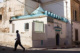
Sidi El Houari was an Algerian imam whose real name was Ben-Amar El Houari. He is the patron saint of the city of Oran in Algeria. The old quarter of Sidi El Houari in Oran is named after him.

<span class="mw-page-title-main">Bethioua</span>

Bethioua is a town and region in the wilaya of Oran in the west of Algeria. It has a gas port, petrochemical facilities and desalination plant.

<span class="mw-page-title-main">Zemmouri</span> Commune and town in Boumerdès Province, Algeria

Zemmouri is a town and commune in the Bordj Menaïel District of Boumerdès Province, Algeria. As of 2008, the population of the municipality is 26,408.

<span class="mw-page-title-main">Gdyel</span> Commune and town in Oran Province, Algeria

Gdyel, former Saint-Cloud, is a town and commune in District Gdyel, Oran Province, Algeria, about 15 miles to the east of Oran. Under French rule, it was the centre of a wine-growing district and was called St. Cloud.

Oued Essalem is a town and commune in Relizane Province, Algeria. According to the 2008 census, it has a population of 9319. It was previously named Henri Hoc under French colonization. The commune is located in the south-west of its province, it spans over 292.95 km2 and the Manesfa River passes through it, it is the largest commune by area of its district. It is linked by the RN23, and is a stop between the large cities of the west, Tiaret, Oran and Mostaganem, it also possesses a departemental road linking it with the town of Oued El Abtal. Located 100 km away from the Mediterranean Sea, Oued Essalem experiences a warm and dry climate, with a slight alpine tendency, its winters are often rainy, and snowfall can sometimes occur.

<span class="mw-page-title-main">Honaine</span> Commune and town in Tlemcen Province, Algeria

Honaine is a town and commune in Tlemcen Province in northwestern Algeria.

<span class="mw-page-title-main">Water supply and sanitation in Algeria</span>

Drinking water supply and sanitation in Algeria is characterized by achievements and challenges. Among the achievements is a substantial increase in the amount of drinking water supplied from reservoirs, long-distance water transfers and desalination at a low price to consumers, thanks to the country's substantial oil and gas revenues. These measures increased per capita water supply despite a rapidly increasing population. Another achievement is the transition from intermittent to continuous water supply in the capital Algiers in 2011, along with considerable improvements in wastewater treatment resulting in better water quality at beaches. These achievements were made possible through a public-private partnership with a private French water company. The number of wastewater treatment plants throughout the country increased rapidly from only 18 in 2000 to 113 in 2011, with 96 more under construction. However, there are also many challenges. One of them is poor service quality in many cities outside Algiers with 78% of urban residents suffering from intermittent water supply. Another challenge is the pollution of water resources. There has also been insufficient progress concerning reuse of treated water, a government priority in this dry country.

The following is a timeline of the history of the city of Oran, Algeria.

<span class="mw-page-title-main">Portus Magnus, Algeria</span>

Portus Magnus was a Roman port in western Mauretania Caesariensis. It was located near Roman Portus Divinus and actual Oran (Algeria).

<span class="mw-page-title-main">Western Beylik</span>

The Beylik of the West was one of three Beyliks (governorates) of the Regency of Algiers, with the other two being the Beylik of Titteri and the Beylik of Constantine. It was established in 1563, and it was ended during the French conquest.

References

Coordinates: 35°47′N0°10′W / 35.783°N 0.167°W / 35.783; -0.167