Mesilla Valley

Last updated
The Mesilla Valley as seen from Las Cruces' west mesa. Mesilla valley.JPG
The Mesilla Valley as seen from Las Cruces' west mesa.
The Organ Mountains tower over the Mesilla Valley (Las Cruces, NM in the foreground). MesillaValley Organs.jpg
The Organ Mountains tower over the Mesilla Valley (Las Cruces, NM in the foreground).

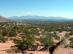
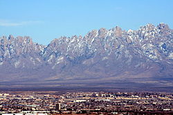
The Mesilla Valley is a geographic feature of Southern New Mexico and far West Texas. It was formed by repeated heavy spring floods of the Rio Grande.

Contents

Background

The fertile Mesilla Valley extends from Radium Springs, New Mexico, to the west side of El Paso, Texas. [1] The valley is characterized by its few remaining bosques, as well as its native cottonwood trees, and increasingly, by invasive tamarisk, which was introduced in the late 19th century, and is known locally as salt cedar.

Due to the fertile nature of the valley, agriculture is a very important activity in this area. Stahmann Farms owns the world's largest pecan orchard, located south of the city of Las Cruces, New Mexico. Alfalfa, cotton, chile, onions and corn are other important cash crops grown in the Mesilla Valley. The Mesilla Valley is also known for its wine-producing capabilities, which originated with the Spanish exploration into New Mexico. It was part of Mexico until Gadsden Purchase in 1853.

Further reading

Related Research Articles

<span class="mw-page-title-main">Rio Grande</span> Major river forming part of the US–Mexico border

The Rio Grande, known in Mexico as the Río Bravo del Norte or simply the Río Bravo, is one of the principal rivers in the southwestern United States and in northern Mexico. The length of the Rio Grande is 1,896 miles (3,051 km), making it the 4th longest river in North America by main stem. It originates in south-central Colorado, in the United States, and flows to the Gulf of Mexico. The Rio Grande drainage basin (watershed) has an area of 182,200 square miles (472,000 km2); however, the endorheic basins that are adjacent to and within the greater drainage basin of the Rio Grande increase the total drainage-basin area to 336,000 square miles (870,000 km2).

<span class="mw-page-title-main">Mesilla, New Mexico</span> Town in New Mexico, United States

Mesilla is a town in Doña Ana County, New Mexico, United States. The population was 2,196 at the 2010 census. It is part of the Las Cruces Metropolitan Statistical Area.

<span class="mw-page-title-main">Gadsden Purchase</span> Land purchased from Mexico by the United States in 1854

The Gadsden Purchase is a 29,670-square-mile (76,800 km2) region of present-day southern Arizona and southwestern New Mexico that the United States acquired from Mexico by the Treaty of Mesilla, which took effect on June 8, 1854. The purchase included lands south of the Gila River and west of the Rio Grande where the U.S. wanted to build a transcontinental railroad along a deep southern route, which the Southern Pacific Railroad later completed in 1881–1883. The purchase also aimed to resolve other border issues.

<span class="mw-page-title-main">New Mexico Territory</span> Territory of the United States of America (1850–1912)

The Territory of New Mexico was an organized incorporated territory of the United States from September 9, 1850, until January 6, 1912. It was created from the U.S. provisional government of New Mexico, as a result of Nuevo México becoming part of the American frontier after the Treaty of Guadalupe Hidalgo. It existed with varying boundaries until the territory was admitted to the Union as the U.S. state of New Mexico. This jurisdiction was an organized, incorporated territory of the US for nearly 62 years, the longest period of any territory in the contiguous United States.

<span class="mw-page-title-main">Confederate Arizona</span> Territory of the Confederate States of America

Arizona Territory, colloquially referred to as Confederate Arizona, was an organized incorporated territory of the Confederate States that existed from August 1, 1861 to May 26, 1865, when the Confederate States Army Trans-Mississippi Department, commanded by General Edmund Kirby Smith, was surrendered at Shreveport, Louisiana. However, after the Battle of Glorieta Pass, the Confederates had to retreat from the territory, and by July 1862, effective Confederate control of the territory had ended. Delegates to the secession convention had voted in March 1861 to secede from the New Mexico Territory and the Union, and seek to join the Confederacy. It consisted of the portion of the New Mexico Territory south of the 34th parallel, including parts of the modern states of New Mexico and Arizona. The capital was Mesilla, along the southern border. The breakaway region overlapped Arizona Territory, established by the Union government in February 1863.

<span class="mw-page-title-main">New Mexico campaign</span> Military operation of the trans-Mississippi theater of the American Civil War

The New Mexico campaign was a military operation of the trans-Mississippi theater of the American Civil War from February to April 1862 in which Confederate Brigadier General Henry Hopkins Sibley invaded the northern New Mexico Territory in an attempt to gain control of the Southwest, including the gold fields of Colorado and the ports of California. Historians regard this campaign as the most ambitious Confederate attempt to establish control of the American West and to open an additional theater in the war. It was an important campaign in the war's Trans-Mississippi Theater, and one of the major events in the history of the New Mexico Territory in the American Civil War.

<span class="mw-page-title-main">First Battle of Mesilla</span> 1861 Civil War battle

The First Battle of Mesilla, was fought on July 25, 1861 at Mesilla in New Mexico Territory, in present-day Doña Ana County, New Mexico.

<span class="mw-page-title-main">Tularosa Basin</span>

The Tularosa Basin is a graben basin in the Basin and Range Province and within the Chihuahuan Desert, east of the Rio Grande in southern New Mexico and West Texas, in the Southwestern United States.

<span class="mw-page-title-main">Roman Catholic Diocese of El Paso</span> Latin Catholic ecclesiastical jurisdiction in Texas, USA

The Diocese of El Paso is a Latin Church ecclesiastical territory or diocese of the Catholic Church in West Texas. Covering 26,686 square miles (69,120 km2), it encompasses the Texas counties of El Paso, Brewster, Culberson, Hudspeth, Jeff Davis, Loving, Presidio, Reeves, Ward and Winkler with approximately 668,000 professing members, being 80.8% of the total population, served by 107 priests, 54 parishes and 237 male and female religious. The see is a suffragan of the Archdiocese of San Antonio.

<span class="mw-page-title-main">Fort Selden</span> United States historic place in New Mexico

Fort Selden was a United States Army post, occupying the area in what is now Radium Springs, New Mexico. The site was long a campground along the El Camino Real de Tierra Adentro. It was the site of a Confederate Army camp in 1861. The U.S. Army established Fort Selden in 1865 for the purpose of protecting westward settlers from Native American raids, but the post fell into disrepair after the American Civil War. It was ultimately abandoned in 1891, due in large part to the decision to expand Fort Bliss and the lack of any expenditures for repair of the facility.

The Mesilla Valley AVA is an American Viticultural Area located primarily in the state of New Mexico with a small area in the state of Texas. Spanish explorer Don Juan de Oñate arrived in the area in 1598 and named a Native American village in the valley Trenquel de la Mesilla, from which the valley as a whole became known as Mesilla Valley. Although viticulture began in nearby El Paso as early as 1650, grapes were first planted in the Mesilla Valley only in the early twentieth century, near the town of Doña Ana. The climate in the Mesilla Valley is dry and hot.

<span class="mw-page-title-main">Traditional Arizona</span> Aspect of state history

Prior to the adoption of its name for a U.S. state, Arizona was traditionally defined as the region south of the Gila River to the present-day Mexican border, and between the Colorado River and the Rio Grande. It encompasses present-day Southern Arizona and the New Mexico Bootheel plus adjacent parts of Southwestern New Mexico. This area was transferred from Mexico to the United States in the Gadsden Purchase of 1853. Mining and ranching were the primary occupations of traditional Arizona's inhabitants, though growing citrus fruits had long been occurring in Tucson.

Founded as El Paso del Norte by Spanish Franciscan friars at an important mountain pass, the area became a small agricultural producer though most settlement was south of the river where modern Mexico lies. The city was considered part of New Mexico under Spanish Conquerors and was tied economically to Santa Fe, New Mexico and the Chihuahuan mining districts of San Felipe El Real and San José del Parral.

The Second Battle of Mesilla was an unusual engagement of the American Civil War. It was fought on July 1, 1862, and was the last engagement between Union and Confederate forces in the Arizona Territory. A skirmish outside of Confederate Arizona's capital of Mesilla between a confederate party and local pro-Union New Mexican guerrillas resisting the Confederate foraging expedition, resulted in a United States victory. Various accounts report from seven to twelve Confederates killed, including their commander Capt. Cleaver of the 7th Texas Infantry and as many as 40 of the local guerrillas.

Fort Thorn or Fort Thorne, originally Cantonment Garland, was a settlement and military outpost located on the west bank of the Rio Grande, northwest of present-day Hatch, and west of Salem in Doña Ana County, New Mexico, United States. It was named for 1st Lt. Herman Thorn of the 2nd U.S. Infantry drowned in the Colorado River in 1849. He had previously been an aide to General John Garland, the new commander of the Ninth Military District, that encompassed New Mexico Territory in 1853.

The Butterfield Overland Mail was a transport and mail delivery system that employed stagecoaches that travelled on a specific route between St. Louis, Missouri and San Francisco, California and which passed through the New Mexico Territory. It was created by the United States Congress on March 3, 1857, and operated until March 30, 1861. The route that was operated extended from where the ferry across the Colorado River to Fort Yuma Station, California was located, through New Mexico Territory via, Tucson to the Rio Grande and Mesilla, New Mexico then south to Franklin, Texas, midpoint on the route. The New Mexico Territory mail route was divided into two divisions each under a superintendent. Tucson was the headquarters of the 3rd Division of the Butterfield Overland Mail Company. Franklin Station in the town of Franklin,, was the headquarters of the 4th Division.

Picacho, is a populated place in Doña Ana County, New Mexico. It lies at an elevation of 3,907 feet / 1,191 meters.

Rincon Valley is a valley through which the Rio Grande flows in New Mexico. Rincon Valley heads at 33°02′54″N107°16′41″W at an elevation of 4,195 feet in a narrow gap between the Caballo Mountains on the east and bluffs on the west bank of the Rio Grande south of where Red Canyon meets the river, in Sierra County, New Mexico. Its mouth is at an elevation of 3,973 feet where it emerges from a narrow canyon between the Selden Hills on the northeast bank of the river and Robledo Mountains on the southwest bank, into the Mesilla Valley at Radium Springs in Doña Ana County, New Mexico.

La Mesilla is a census-designated place in Río Arriba County, New Mexico, United States. Its population was 1,772 as of the 2010 census.

<span class="mw-page-title-main">Rio Grande Valley (New Mexico)</span> River valley of the Rio Grande in New Mexico, United States

The Rio Grande Valley is the river valley carved out by the Rio Grande as it flows through the American Southwest and northeastern Mexico, forming a part of the border region. In the US state of New Mexico, the river flows mostly north to south, and forms a valley near Cochiti Pueblo to the state line near El Paso, Texas along the floors of the large sedimentary basins of the Rio Grande Rift, and includes the narrow sections between the basins. It has been historically settled first by the Pueblo peoples, the Spanish, the Mexicans, and finally Anglo-Americans. As the largest river in the state, some of its most populous cities are located wholly or partially in the valley, including Albuquerque, New Mexico's largest city.

References

  1. Chang, C. W. (1953). "Chemical Properties of Alkali Soils in Mesilla Valley, New Mexico". Soil Science. 75 (3): 233–242. doi:10.1097/00010694-195303000-00008.

Coordinates: 31°47′25″N106°25′24″W / 31.79028°N 106.42333°W / 31.79028; -106.42333