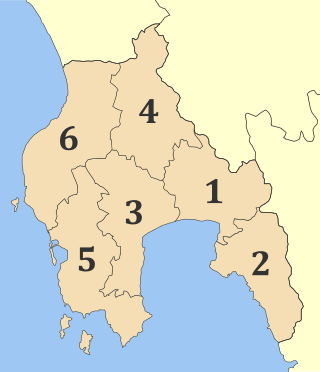
Messenia or Messinia is a regional unit in the southwestern part of the Peloponnese region, in Greece. Until the implementation of the Kallikratis plan on 1 January 2011, Messenia was a prefecture (nomos) covering the same territory. The capital and largest city of Messenia is Kalamata.

Monemvasia is a town and municipality in Laconia, Greece. The town is located on a small island off the east coast of the Peloponnese, surrounded by the Myrtoan Sea. The island is connected to the mainland by a short causeway 200 metres (660 ft) in length. Its area consists mostly of a large plateau some 100 m (330 ft) above sea level, up to 300 m (980 ft) wide and 1 kilometre (0.62 mi) long. Founded in the sixth century, and thus one of the oldest continually-inhabited fortified towns in Europe, the town is the site of a once-powerful medieval fortress, and was at one point one of the most important commercial centres in the Eastern Mediterranean. The town's walls and many Byzantine churches remain as testaments to the town's history. Today, the seat of the municipality of Monemvasia is the town of Molaoi.

Methoni is a village and a former municipality in Messenia, Peloponnese, Greece. Since the 2011 local government reform it is part of the municipality of Pylos-Nestoras, of which it is a municipal unit. The municipal unit has an area of 97.202 km2. Its name may be derived from Mothona, a mythical rock. It is located 11 km south of Pylos and 11 km west of Foinikounta. The municipal unit of Methoni includes the nearby villages of Grizokampos, Finikouda, Foiniki, Lachanada, Varakes, Kainourgio Chorio, Kamaria, Evangelismos, and the Oinnoussai Islands. The islands are Sapientza, Schiza, and Santa Marina; they form a natural protection for Methoni harbour. The town is also known by the Italian name Modone, which it was called by the Venetians.

Koroni or Corone is a town and a former municipality in Messenia, Peloponnese, Greece. Since the 2011 local government reform it is part of the municipality Pylos-Nestoras, of which it is a municipal unit. Known as Corone by the Venetians and Ottomans, the town of Koroni sits on the southwest peninsula of the Peloponnese on the Gulf of Messinia in southern Greece, 56 km (35 mi) by road southwest of Kalamata. The town is nestled on a hill below a Venetian castle and reaches to the edge of the gulf. The town was the seat of the former municipality of Koróni, which has a land area of 105 km2 (41 sq mi) and a population of 4,366. The municipal unit consists of the communities Akritochori, Charakopio, Chrysokellaria, Falanthi, Kaplani, Kompoi, Koroni, Vasilitsi, Vounaria and Iamia. It also includes the uninhabited island of Venétiko.

The siege of Thessalonica between 1422 and 1430 saw the Ottoman Empire under Sultan Murad II capture the city of Thessalonica, which remained in Ottoman hands for the next five centuries, until it became part of the Kingdom of Greece in 1912.

The Koules or Castello a Mare is a fortress located at the entrance of the old port of Heraklion, Crete, Greece. It was built by the Republic of Venice in the early 16th century, and is still in good condition today.

The fortifications of Kotor are an integrated historical fortification system that protected the medieval town of Kotor containing ramparts, towers, citadels, gates, bastions, forts, cisterns, a castle, and ancillary buildings and structures. They incorporate military architecture of Illyria, the Byzantine Empire, Venice, and Austria. Together with the old town and its natural surroundings the fortifications were inscribed in the list of World Heritage Sites in 1979 labelled Natural and Culturo-Historical Region of Kotor and represent the only such site of cultural significance in Montenegro.

Chlemoutsi, also known as Clermont, is a medieval castle in the northwest of the Elis regional unit in the Peloponnese peninsula of southern Greece, in the Kastro-Kyllini municipality.

The Old Navarino castle is a 13th-century Frankish fortress near Pylos, Greece. It is one of two castles guarding the strategic bay on which it sits; the other is the Ottoman-built New Navarino fortress. In juxtaposition with the latter, it is frequently known simply as Palaiokastro or Paliokastro. It occupies the site of the Athenian fort at the 425 BC Battle of Pylos.

The Walls of Nicosia, also known as the Venetian Walls, are a series of defensive walls which surround Nicosia the capital city of Cyprus. The first city walls were built in the Middle Ages, but they were completely rebuilt in the mid-16th century by the Republic of Venice. The walls are still largely intact, and are among the best preserved Renaissance fortifications in the Eastern Mediterranean. They are a major tourist attraction.

A bridge castle is a type of castle that was built to provide military observation and security for a river crossing. In the narrower sense it refers to castles that are built directly on or next to a bridge. Sometimes, however, castles close to a bridge are referred to as bridge castles.

Kassiopi Castle is a castle on the northeastern coast of Corfu overseeing the fishing village of Kassiopi. It was one of three Byzantine-period castles that defended the island before the Venetian era (1386–1797). The castles formed a defensive triangle, with Gardiki guarding the island's south, Kassiopi the northeast and Angelokastro the northwest.

The island of Cyprus was an overseas possession of the Republic of Venice from 1489, when the independent Kingdom of Cyprus ended, until 1570–71, when the island was conquered by the Ottoman Empire.
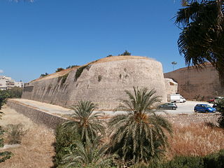
The fortifications of Heraklion are a series of defensive walls and other fortifications which surround the city of Heraklion in Crete, Greece. The first city walls were built in the Middle Ages, but they were completely rebuilt by the Republic of Venice. The fortifications managed to withstand the second longest siege in history for 21 years, before the city fell to the Ottomans in 1669.
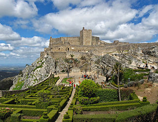
The Castle of Marvão is a well-preserved medieval castle located in the civil parish of Santa Maria de Marvão, in the municipality of Marvão, Portuguese district of Portalegre.
Skiathos Castle or simply Kastro is a medieval fortified site on the northern tip of the island of Skiathos in Greece, which was the main settlement of the island from the mid-14th century to 1829. It is now abandoned and a protected site.
Alvise Loredan was a Venetian nobleman of the Loredan family. At a young age he became a galley captain, and served with distinction as a military commander, with a long record of battles against the Ottomans, from the naval expeditions to aid Thessalonica, to the Crusade of Varna, and the opening stages of the Ottoman–Venetian War of 1463–1479, as well as the Wars in Lombardy against the Duchy of Milan. He also served in a number of high government positions, as provincial governor, savio del consiglio, and Procuratore de Supra of Saint Mark's Basilica.
The Ottoman reconquest of the Morea took place in June–September 1715, during the Seventh Ottoman–Venetian War. The Ottoman army, under Grand Vizier Silahdar Damat Ali Pasha, aided by the fleet under Kapudan Pasha Canım Hoca Mehmed Pasha, conquered the Morea peninsula in southern Greece, which had been captured by the Republic of Venice in the 1680s, during the Sixth Ottoman–Venetian War. The Ottoman reconquest inaugurated the second period of Ottoman rule in the Morea, which ended with the outbreak of the Greek War of Independence in 1821.

The Parga Castle is a medieval hilltop citadel complex in the town of Parga, Epirus, Greece. Located on the top of a hill overlooking the town, it has been an important landmark since the 15th century, due in part to the strong fortifications used to protect the town from invasions from land and sea.
This is an alphabetical index of people, places, things, and concepts related to or originating from the Republic of Venice. Feel free to add more, and create missing pages.


